


2.2.0 Commercial and Economic Use
2.2.1 Background
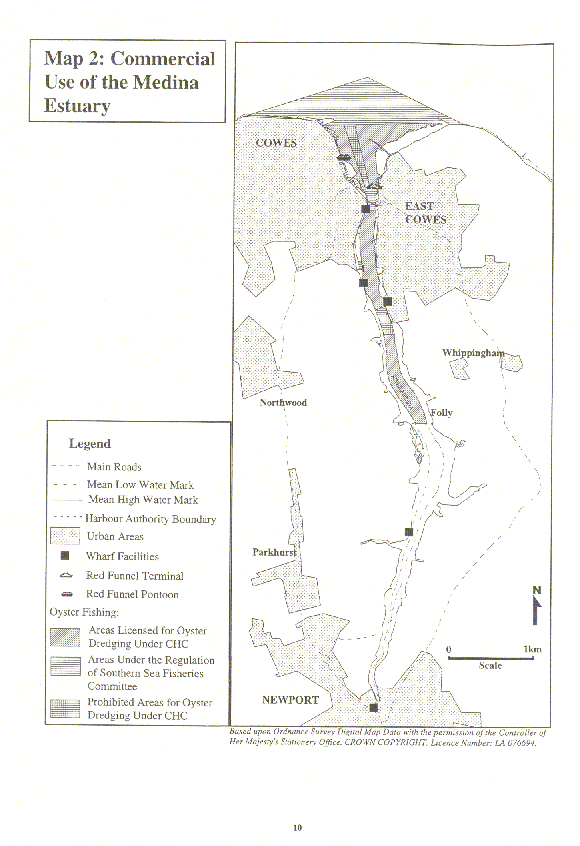
Commercial and economic use of the estuary includes principally: commercial shipping; the marine service industry; the ferry services; commercial fishing; and tourism. The areas of the estuary used for commercial activity are illustrated in Map 2.
Commercial shipping: The Medina Estuary is the only location on the Island which handles bulk cargo. While trade has declined it continues to handle approximately 400,000 tonnes of cargo per annum with the main commodities being shingle/ballast, timber, grain, fuel spirit/oil, stone, pumice/limestone. The majority of the cargo is landed at Kingston and Medina wharves. Newport Harbour continues to receive shingle. However, use of the Harbour for the transportation of cargo is declining as vessel sizes increase. A disused wharf exists at Stag Lane which could potentially be reused in the future to provide better access than Newport Quays.
Marine services: Marine services are provided by an array of businesses within the estuary offering a wide range of services including: boat building and repair; supply (including riggers, sailmakers, engineers and electricians); and support services (chandlers, brokers, towing and mooring facilities). The main foci of marine services is in the vicinity of Cowes but additional businesses are located at Island Harbour and Newport.
Ferry services: Red Funnel operate a high speed passenger service from Cowes and a passenger and vehicle service from East Cowes providing vital links to Southampton and the mainland.
Commercial fishing: Cowes Harbour serves as a port of registry and harbour for commercial craft who fish the wider Solent waters. There are currently no full time commercial fishing vessels registered and based at Cowes. However, Cowes Harbour Commission issue licences to 8 fishing vessels. There is also 1 rod and line vessel (licence not required). The main species commercially fished are oysters, eels, mullet, bass and flounder, together with small quantities of sole and plaice. The main commercial fishing activity which occurs within the estuary is the dredging of oysters. Objectives and recommendations relevant to commercial fishing are also listed in the Fisheries section (2.3).
Tourism: The study area contributes significantly to the Island’s tourism industry. In particular, Cowes is one of the focal points of tourism on the Island, attracting people for events including Cowes Week. In 1992, Cowes attracted 154,000 yachtsmen who spent an estimated £10 million on local goods and services. In addition, an estimated £3.25 million of local expenditure was generated from visitors attracted to yachting (Pieda, 1994).
Future developments: The integrated multi-million pound re-development of Town Quay is now progressing. Partnered by the IWC, CHC, Red Funnel and Cowes Waterfront Trust it will increase public access to the waterfront, re-develop the Red Jet Terminal and increase the size of the Yacht Basin.
Also in Cowes, East Cowes Marina is being developed and there are proposals to develop Shepherds Wharf.
An Aerolaminates Ltd. Marine Transfer Unit on the Western bank of the estuary just north of Newport is also under development review. Another major potential development at Newport is the regeneration of Newport Harbour for which the Isle of Wight Council is currently (1999) examining the options.
Regulation: Cowes Harbour Commissioners (CHC) and Newport Harbour Authority (NHA) have statutory responsibility for conservation and navigation within the estuary and have the powers to make byelaws for regulation purposes. CHC jurisdiction, as established by the Cowes Harbour Act 1897, extends on the northern boundary from Egypt Point to Prince Consort Buoy to Castle Point and thereafter on the foreshore at the high water mark throughout the estuary to an east-west boundary at the Folly Inn, as indicated on Map 2. South of the boundary the estuary is regulated by the Isle of Wight Council as Newport Harbour Authority, who own the river bed south of the boundary. The Harbour Authorities are also responsible for providing licences for dredging and navigational licences for oyster dredging within the estuary. Commercial fishing in the Solent is regulated by the Southern Sea Fisheries Committee (SSFC) . The SSFC regulate inshore fishing via the implementation of byelaws. The Isle of Wight Council is responsible for planning and development control on the land to the mean low water mark offshore and within the whole of the estuary.
2.2.2 Issues
2.2.2.1 Future commercial use of the estuary
Commercial and economic use of the estuary is in decline following the change in cargo transportation from sea to overland and the recent recession, which has had an impact on the marine services sector. It is necessary to examine the commercial and economic use of the estuary as a whole to identify a means for ensuring continued economic productivity and the availability of sites for commercial activity in the future.
2.2.1 Background
Commercial and economic use of the estuary includes principally: commercial shipping; the marine service industry; the ferry services; commercial fishing; and tourism. The areas of the estuary used for commercial activity are illustrated in Map 2.
Commercial shipping: The Medina Estuary is the only location on the Island which handles bulk cargo. While trade has declined it continues to handle approximately 400,000 tonnes of cargo per annum with the main commodities being shingle/ballast, timber, grain, fuel spirit/oil, stone, pumice/limestone. The majority of the cargo is landed at Kingston and Medina wharves. Newport Harbour continues to receive shingle. However, use of the Harbour for the transportation of cargo is declining as vessel sizes increase. A disused wharf exists at Stag Lane which could potentially be reused in the future to provide better access than Newport Quays.
Marine services: Marine services are provided by an array of businesses within the estuary offering a wide range of services including: boat building and repair; supply (including riggers, sailmakers, engineers and electricians); and support services (chandlers, brokers, towing and mooring facilities). The main foci of marine services is in the vicinity of Cowes but additional businesses are located at Island Harbour and Newport.
Ferry services: Red Funnel operate a high speed passenger service from Cowes and a passenger and vehicle service from East Cowes providing vital links to Southampton and the mainland.
Commercial fishing: Cowes Harbour serves as a port of registry and harbour for commercial craft who fish the wider Solent waters. There are currently no full time commercial fishing vessels registered and based at Cowes. However, Cowes Harbour Commission issue licences to 8 fishing vessels. There is also 1 rod and line vessel (licence not required). The main species commercially fished are oysters, eels, mullet, bass and flounder, together with small quantities of sole and plaice. The main commercial fishing activity which occurs within the estuary is the dredging of oysters. Objectives and recommendations relevant to commercial fishing are also listed in the Fisheries section (2.3).
Tourism: The study area contributes significantly to the Island’s tourism industry. In particular, Cowes is one of the focal points of tourism on the Island, attracting people for events including Cowes Week. In 1992, Cowes attracted 154,000 yachtsmen who spent an estimated £10 million on local goods and services. In addition, an estimated £3.25 million of local expenditure was generated from visitors attracted to yachting (Pieda, 1994).
Future developments: The integrated multi-million pound re-development of Town Quay is now progressing. Partnered by the IWC, CHC, Red Funnel and Cowes Waterfront Trust it will increase public access to the waterfront, re-develop the Red Jet Terminal and increase the size of the Yacht Basin.
Also in Cowes, East Cowes Marina is being developed and there are proposals to develop Shepherds Wharf.
An Aerolaminates Ltd. Marine Transfer Unit on the Western bank of the estuary just north of Newport is also under development review. Another major potential development at Newport is the regeneration of Newport Harbour for which the Isle of Wight Council is currently (1999) examining the options.
Regulation: Cowes Harbour Commissioners (CHC) and Newport Harbour Authority (NHA) have statutory responsibility for conservation and navigation within the estuary and have the powers to make byelaws for regulation purposes. CHC jurisdiction, as established by the Cowes Harbour Act 1897, extends on the northern boundary from Egypt Point to Prince Consort Buoy to Castle Point and thereafter on the foreshore at the high water mark throughout the estuary to an east-west boundary at the Folly Inn, as indicated on Map 2. South of the boundary the estuary is regulated by the Isle of Wight Council as Newport Harbour Authority, who own the river bed south of the boundary. The Harbour Authorities are also responsible for providing licences for dredging and navigational licences for oyster dredging within the estuary. Commercial fishing in the Solent is regulated by the Southern Sea Fisheries Committee (SSFC) . The SSFC regulate inshore fishing via the implementation of byelaws. The Isle of Wight Council is responsible for planning and development control on the land to the mean low water mark offshore and within the whole of the estuary.
2.2.2 Issues
2.2.2.1 Future commercial use of the estuary
Commercial and economic use of the estuary is in decline following the change in cargo transportation from sea to overland and the recent recession, which has had an impact on the marine services sector. It is necessary to examine the commercial and economic use of the estuary as a whole to identify a means for ensuring continued economic productivity and the availability of sites for commercial activity in the future.
| Objective C1 To identify the means to establish alternative commercial opportunities and attract new businesses to the area. |
|---|
| Objective C2 To reserve, where appropriate, riverside land or areas of the harbour with adjacent deep water for river dependent activities. |
|---|
2.2.2.2 Dredging
Maintenance dredging of existing shipping channels and berths, which have been affected by siltation, occurs regularly within the estuary. This must continue in order to provide access to the estuary for commercial shipping, the ferry service and recreational craft.
| Objective C3 To maintain access channels and wharves, subject to technical and environmental considerations. |
|---|
2.2.2.3 Fishing facilities provision in Cowes
There are no dedicated fishing facilities for the landing of commercial catches and the storage of gear within the estuary.
| Objective C4 To investigate the feasibility of providing landing and storage facilities for the commercial fishermen registered at Cowes. |
|---|
2.2.2.4 Tourism
Tourism within the study area is severely limited by the inadequate provision of appropriate accommodation, public transport, ancillary facilities, the unrealised potential of the historical and cultural resource and the promotion of the area.
| Objective C5 To improve the tourism resource and actively promote tourism. |
|---|
2.2.2.5 Conflict between commercial activities and recreational use
Conflict between commercial craft and recreation users of the water occurs along the length of the estuary but is primarily an issue of concern in Cowes Harbour during the main sailing season. CHC are in regular communication with clubs and organisations to examine ways to address this issue and have established radio communication between commercial craft and recreational users/organisations. The development of the eastern channel for use by commercial craft would also potentially reduce the conflict within the harbour.
| Objective C6 To continue to develop strategies and the means of communication to ensure that conflict between commercial and recreational users is minimised. |
|---|
Map 2: Commercial and Economic Use
of the Medina
Click here to see the whole map
Click here to see the Commercial and Economic Use Action Plan
Page last updated on: 04/09/2001