


2.6.0 Nature Conservation
2.6.1 Background
The Medina Estuary is a significant wildlife resource which supports a diverse and complex mosaic of habitats, which are of value in themselves, while supporting a wide range of species.
Subtidal: The estuary has one main channel which supports a variety of fish species and invertebrates. Knowledge about these species is limited.
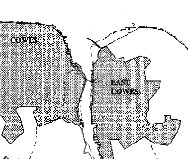
Intertidal muds: This habitat is dependent on the continual deposition of sediment at a rate equal to that lost through erosion, dredging and rising sea levels. The intertidal muds extend along much of the length of the estuary and include large areas of mudflats and the shrape muds at East Cowes. The muds support a large number of species, including shellfish, algae and locally and regionally important species of worm, which are important sources of food for fish and bird populations. In addition, the intertidal muds of the shrape support an important area of eel-grass beds.
Saltmarsh: The saltmarsh habitat develops from continued deposition on to, and colonisation of the mudflats. It consists of a sea couch-grass zone which persists along much of the estuary and numerous saltmarsh fragments. The saltmarsh is an important habitat for breeding waders and is a high tide roost. In addition, seven nationally important species of plant have been recorded within this habitat.
Freshwater marsh: Two relatively small but important freshwater and brackish marshes exist inland from the western shore of the estuary at Dodnor and Lower St Cross. These habitats support stands of common reed, sedges and reedmace and are used by some waterfowl species as a high water roost. They support breeding bird populations. Dodnor Creek is important ecologically for its transition from fen vegetation through marginal scrub to ancient woodland and supports reedmace and sea club rush stands.
Scrub, hedgerows and woodland: Much of the shoreline is fringed by mixed deciduous woodland and scrub. Dicksons Copse supports at least 28 ancient woodland indicator species (those normally associated with woodlands more than 400 years old). The nationally scarce narrow-leaved lungwort and a notable community of woodland ferns including hart's tongue and the soft shield fern can be found in the copse. Red squirrels and dormice, both protected species, are found in the woods and scrub bordering the estuary.
Grassland: Grassland within the valley is mainly grazed by cattle or managed for playing fields and amenity. It also includes a number of unimproved grassland sites including the Medina Valley Centre Nature Reserve and the Medina Riverside Park, at the southern end of the cycleway. Grassland habitats provide important breeding and feeding sites for birds and improved grassland can also be important as high tide wader roosts.
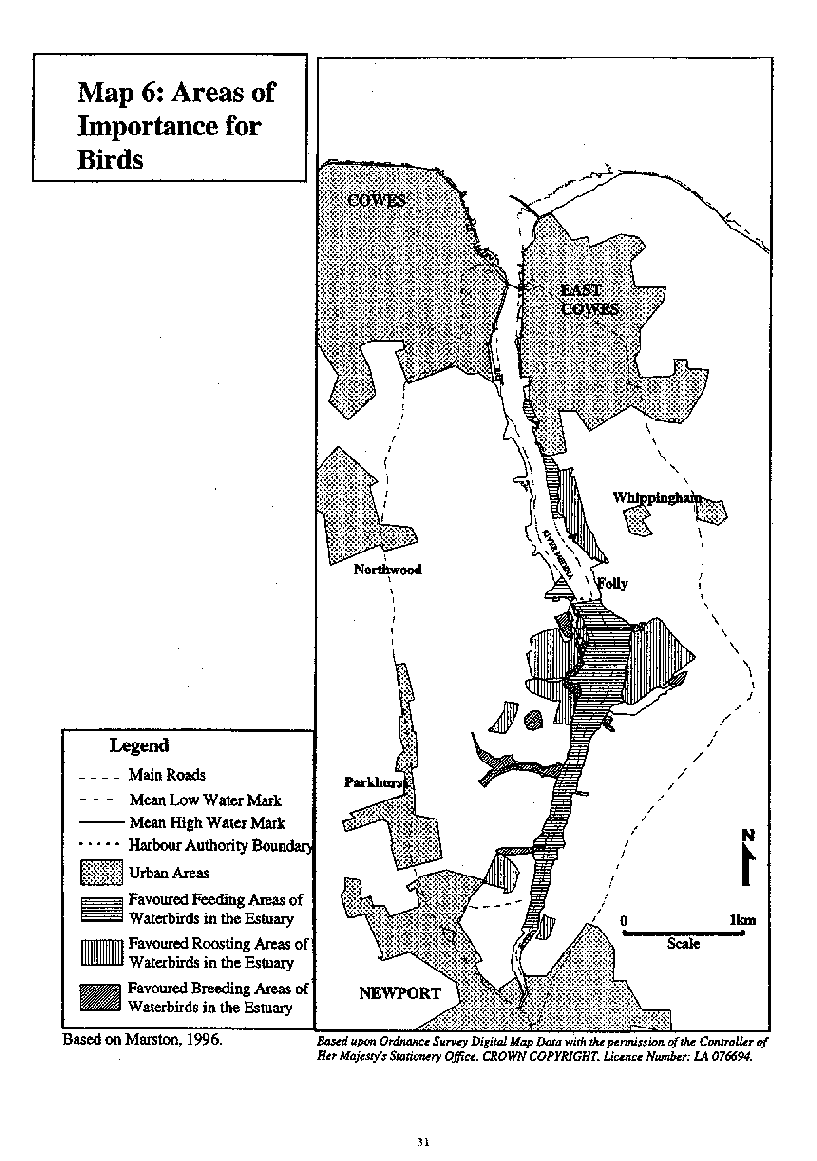
In total the estuary habitats provide important feeding, breeding and roosting grounds for birds. They support locally important numbers of oystercatchers, occasionally support nationally important numbers of black-tailed godwits and are an important component of the internationally important Solent estuarine system. Seasonally, the Medina regularly supports 19 species of wildfowl, 15 species of wader, 4 species of gull and 2 of tern (Marston, 1996). A steady increase in the populations of waders and waterfowl have been recorded since the 1970s. Map 6 illustrates the areas of the estuary used by the waterbirds for feeding, breeding and roosting.
The importance of the nature conservation resource is reflected by the various tiers of designation at an international, national and local level.
2.6.1 Background
The Medina Estuary is a significant wildlife resource which supports a diverse and complex mosaic of habitats, which are of value in themselves, while supporting a wide range of species.
Subtidal: The estuary has one main channel which supports a variety of fish species and invertebrates. Knowledge about these species is limited.
Intertidal muds: This habitat is dependent on the continual deposition of sediment at a rate equal to that lost through erosion, dredging and rising sea levels. The intertidal muds extend along much of the length of the estuary and include large areas of mudflats and the shrape muds at East Cowes. The muds support a large number of species, including shellfish, algae and locally and regionally important species of worm, which are important sources of food for fish and bird populations. In addition, the intertidal muds of the shrape support an important area of eel-grass beds.
Saltmarsh: The saltmarsh habitat develops from continued deposition on to, and colonisation of the mudflats. It consists of a sea couch-grass zone which persists along much of the estuary and numerous saltmarsh fragments. The saltmarsh is an important habitat for breeding waders and is a high tide roost. In addition, seven nationally important species of plant have been recorded within this habitat.
Freshwater marsh: Two relatively small but important freshwater and brackish marshes exist inland from the western shore of the estuary at Dodnor and Lower St Cross. These habitats support stands of common reed, sedges and reedmace and are used by some waterfowl species as a high water roost. They support breeding bird populations. Dodnor Creek is important ecologically for its transition from fen vegetation through marginal scrub to ancient woodland and supports reedmace and sea club rush stands.
Scrub, hedgerows and woodland: Much of the shoreline is fringed by mixed deciduous woodland and scrub. Dicksons Copse supports at least 28 ancient woodland indicator species (those normally associated with woodlands more than 400 years old). The nationally scarce narrow-leaved lungwort and a notable community of woodland ferns including hart's tongue and the soft shield fern can be found in the copse. Red squirrels and dormice, both protected species, are found in the woods and scrub bordering the estuary.
Grassland: Grassland within the valley is mainly grazed by cattle or managed for playing fields and amenity. It also includes a number of unimproved grassland sites including the Medina Valley Centre Nature Reserve and the Medina Riverside Park, at the southern end of the cycleway. Grassland habitats provide important breeding and feeding sites for birds and improved grassland can also be important as high tide wader roosts.
In total the estuary habitats provide important feeding, breeding and roosting grounds for birds. They support locally important numbers of oystercatchers, occasionally support nationally important numbers of black-tailed godwits and are an important component of the internationally important Solent estuarine system. Seasonally, the Medina regularly supports 19 species of wildfowl, 15 species of wader, 4 species of gull and 2 of tern (Marston, 1996). A steady increase in the populations of waders and waterfowl have been recorded since the 1970s. Map 6 illustrates the areas of the estuary used by the waterbirds for feeding, breeding and roosting.
The importance of the nature conservation resource is reflected by the various tiers of designation at an international, national and local level.
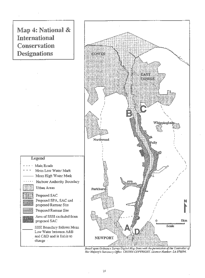
- The importance of the Medina Estuary, within the wider Solent estuarine system, both for bird life and habitats is reflected in the three international designations for the area: the Solent and Southampton Water Special Protection Area (SPA); the candidate Solent Maritime Special Area of Conservation (cSAC); and the Solent and Southampton Water Ramsar Site.
- At a national level, a large proportion of the Estuary is designated as a Site of Special Scientific Interest (SSSI).
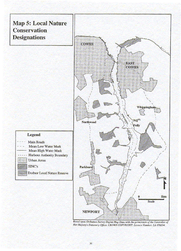
- At a local level, the designation of Sites of Importance for Nature Conservation (SINC) and Dodnor Local Nature Reserve (LNR) indicate conservation significance at the County level.
The extent of each of these designations within the Medina Estuary is illustrated on Maps 4 and 5.
Regulation: The bodies with a responsibility for protecting the nature conservation resource include, English Nature (EN), Isle of Wight Council and the Environment Agency (EA). Cowes Harbour Commission (CHC) are empowered to issue works licenses and therefore have a duty of care to the environment taking into consideration the Habitats Directive. EN is the government body responsible for nature conservation in England. It has a duty to identify nationally and internationally important sites for nature conservation, to advise on appropriate management to ensure the protection of habitats and species and to ensure that national and international obligations are met. Consultation with EN is required for any proposal which may affect, directly or indirectly, areas designated as SSSI, SPA, Ramsar and cSAC. Sites of Importance for Nature Conservation and Local Nature Reserves are identified by the Isle of Wight Council. The Isle of Wight Council as Planning Authority protect the natural resource through their policy and development control functions. The EA has a duty to further or have regard to the conservation of flora, fauna, geological and physical features of special interest whilst carrying out its own function.
2.6.2 Issues
2.6.2.1 Development
Development may involve direct or indirect impacts on the nature conservation resource. Direct impacts may occur due to habitat loss caused by development or the creation of new habitats. This may result in a reduction of habitat area, species populations and species diversity. Indirect impacts of development may occur due to disturbance, pollution, habitat fragmentation and modification of the sediment patterns of accretion and erosion.
| Objective NC1 To minimise the adverse impact of development on the nature conservation resource. |
|---|
| Objective NC2 To maximise opportunities to conserve and enhance the nature conservation resource. |
|---|
2.6.2.2 Protection of Designated Areas
National and international nature conservation designations are supported by national and international legislation to ensure that the sites are safeguarded. The full implications associated with national and international designations need to be more widely communicated to estuary users.
| Objective NC3 To ensure that appropriate protection is given to designated areas of the estuary |
|---|
2.6.2.3 Disturbance to habitats and wildlife
All activities which occur within the Medina Estuary cause a degree of disturbance to wildlife and the nature conservation resource. Activities of primary concern are: angling, bait digging, dog walking, capital and maintenance dredging, land-use change; walking; and water based recreation.
- Angling, bait digging, dog walking and walkers disturb breeding, feeding and roosting birds. Individuals straying from public rights of way may cause disturbance in areas which are important habitats.
- Capital and maintenance dredging results in the removal of sediment and potential alteration to patterns of sediment transport and accretion which may influence the intertidal and saltmarsh habitats.
- Land use change may result in the loss of important feeding, roosting and breeding grounds for birds or the loss of important habitats or species.
The possible introduction of international conservation designations may require appropriate steps to avoid significant disturbance to certain birds species and habitats to be taken.
| Objective NC4 To minimise disturbance to estuarine habitats and wildlife in recognition of international obligations. |
|---|
2.6.2.4 Saltmarsh erosion
Saltmarsh erosion is occurring predominantly in the middle and upper reaches of the estuary. The habitat is an important roosting and breeding ground and is known to support seven nationally important species. Knowledge of the cause and rates of erosion is unknown and survey work and monitoring work is imperative to provide information.
A bid for funding under the EU LIFE Environment Programme for the ‘Beneficial use of dredgings in intertidal recharge’ is currently being prepared (1999-2000). This project will actively examine the beneficial use of dredgings for intertidal recharge and re-creation. This is a Solent-wide project which is a partnership between Chichester Harbour Conservancy, EA, EN, Hampshire County Council, IWC, New Forest District Council and SCOPAC (Standing Conference On Problems Associated with the Coastline).
| Objective NC5 To monitor and conserve the saltmarsh habitat and where appropriate encourage opportunities for re-creation. |
|---|
2.6.2.5 Pollution
Poor water quality or pollution incidents are likely to have a detrimental impact upon the nature conservation resource.
Objectives and recommendations relevant to water quality are listed in the Water Management section (2.9).
2.6.2.6 Information and data
Information and data concerning the nature conservation resource is not comprehensive and is held by a number of organisations and individuals. Regular, co-ordinated information collection and analysis is required to ensure that comprehensive information about the resource exists. In addition, research and information is lacking about the interaction and impact of other activities on the resource. Areas which require research include:
- the impacts of bait digging;
- the impacts of shell fishing;
- saltmarsh erosion;
- methods for saltmarsh reclamation/ protection;
- effects and accumulative effects of dredging on habitats and wildlife in the estuary;
- the sub-tidal nature conservation resource; and
- current Tri Butyl Tin (TBT) levels and its ecological effects.
Another bid for funding under the EU LIFE Nature Programme was approved in 1999. Driven by EN and titled ‘Living with the sea: Managing Natura 2000 Sites on Dynamic Coastlines’ this will produce CHAMPS (Coastal Habitat Management Plans) which will provide 50 year strategies for the Management of coasts.
| Objective NC6 To achieve co-ordinated, comprehensive information about the nature conservation resource. |
|---|
Map 4: National and International
Conservation Designations
Click here to see the whole map
Map 5: Local Nature Conservation Designations
Click here to see the whole map
Map 6: Areas of Importance for Birds
Click here to see the whole map
Click here to see the Nature Conservation Action Plan
Page last updated on: 04/09/2001