


2.8.0 Recreation and Leisure
2.8.1 Background
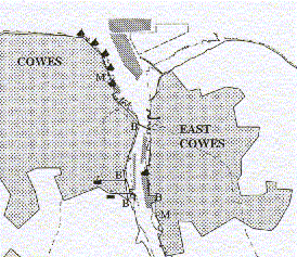
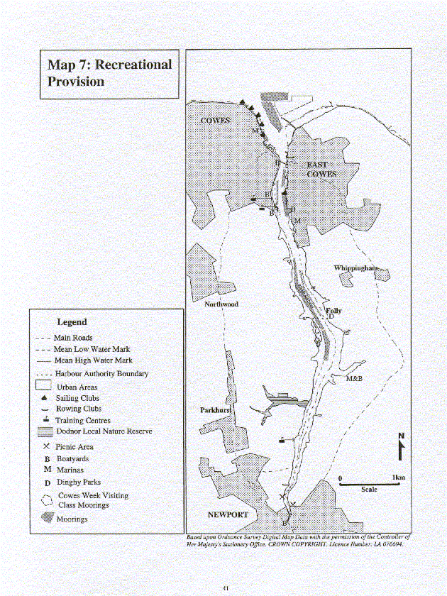
The estuary supports a range of recreational activities, both on the water and on the adjacent land, including: yachting, cruising, dinghy sailing, canoeing, rowing, windsurfing, angling, walking, cycling and bird watching. It is the only one of the four estuaries on the Isle of Wight which is accessible to the public along most of the shoreline and intertidal areas. It is used by individuals, clubs, training centres and for organised events and regattas. In 1996, approximately 250 water based and 15 land based recreation events were organised. Recreation facilities on the estuary include sailing and rowing clubs, training centres, slipways and landing facilities, marinas, moorings, public footpaths and a cyclepath. Maps 7 and 8 illustrate the location of recreational provision and public access within the estuary.
Angling: The Medina is a popular recreational fishing location for club competitions and the individual angler. Fishing is carried out from the shore and boats throughout the estuary at all times of the day and year with the main season occurring between October and March. Anglers principally fish for flounder, mullet and bass. The estuary is used regularly by 9 of the 18 Island based angling clubs, with approximately 90 competitions being held annually on the estuary. The estuary is also the most important source of worm bait for the Island’s anglers. Of the approximate 75 miles of coastline on the Island, bait can be dug from only a 10 mile section, 6 miles of which are in the Medina Estuary.
Watching birds and other wildlife: Watching birds and other wildlife is very popular along the shores of the estuary. It occurs most extensively in areas adjacent to Dodnor Creek, Kingston mudflats, Folly Lake, Pinkmead Creek and the mudflats adjacent to the Medina Valley Centre. The estuary is also used as a field study site for courses provided by the Medina Valley Centre.
Canoeing / Kayaking: Training centres and clubs use the length of the estuary for canoeing. Canoe training tends to remain within the estuary, while individual canoeists canoe within the estuary or travel along the adjacent open coast.
Cycling: The cyclepath, which follows the route of the former railway line between Cowes and Newport is a popular route for recreational cyclists and commuters, and serves as a link between Newport and Cowes. Cyclists also use public footpaths on the eastern side of the estuary.
Jet skis: Jet skis are launched from East Cowes beach and use areas of the open coast. Harbour byelaws stipulate a six knot speed limit within its jurisdiction which limits jet ski activity within the estuary.
Rowing: The estuary is used by both Newport and Ryde Rowing Clubs who use the length of the estuary for training. Craft are launched from either Newport Rowing Club or from the White Hart Slip in East Cowes. Approximately 7 rowing events are held per annum, primarily in the middle and lower reaches of the estuary.
Yachting/Cruising/Dinghy Sailing: For racing, the Medina Estuary is a haven from which sailing craft operate, with the climax occurring in August with Cowes Week. This primarily occurs within the areas north of Whitegates and East Cowes Marina. In the interest of safety, the majority of the yachting events are not undertaken within Cowes Harbour or the estuary. The only exceptions are events organised by East Cowes Sailing Club and Cowes Corinthian Yacht Club which have consent during the autumn months to undertake sailing events on start lines within the main harbour, clear of the fairway. For the majority of the other yachting events, the estuary is used to berth craft, resulting in Cowes Harbour being busy during the main sailing season from April to October.
Marinas, boatyards and the Harbour Authorities provide moorings for recreational craft throughout the estuary attracting yachts and cruising craft south of Cowes into the lower reaches of the estuary. South of Folly Inn craft are restricted to the main channel of the estuary and are limited by the tidal window.
Due to its status as a popular sailing location, there are 6 sailing clubs based in the estuary with approximately 65% of its membership comprising members from the mainland. Dinghy sailing is particularly commonplace in the mid and upper reaches of the estuary, especially in the Folly Lake and Hurstake area, where intensive dinghy training is carried out by local training establishments. The waters adjacent to East Cowes Beach are also popular for dinghy sailing, especially for novice sailors undertaking a programme of training with one of the local training establishments. When the prevalent conditions are not ideal for dinghy sailing near East Cowes beach, then it is often pursued in the lee of the harbour breakwater. The Medina Mariners’ Association and East Cowes Sailing Club organise dinghy events within the estuary, primarily in the middle reaches.
Rambling/walking: Rambling/walking is very popular along the majority of the footpaths which run adjacent to the shore of the estuary.
Training centres: Three training centres are based on the estuary and use the area for yacht, powerboat, dinghy, canoe and windsurf training.
Windsurfing: Windsurfing is generally pursued on the open coast, both east and west of Cowes Harbour. Windsurfing is not permitted in the harbour, although the occasional windsurfer sails upstream.
2.8.2 Issues
2.8.2.1 Facilities Provision
Recreation facilities within the estuary include:
• club facilities;
• training centres;
• slipways and landing facilities to provide access to the water;
• facilities for yachtsmen including: marinas, moorings, public wash and shower facilities; and
• footpaths and a cycleway to provide access to the countryside along the estuary.
A significant number of slipways only provide limited access to the estuary due to tidal constraints, inappropriate access to the slipway, inadequate parking (including parking for boat trailers) and/or inappropriate slipway surfaces. The slipways regularly used are White Hart in East Cowes, Thetis Wharf, Town Quay and Watch House Slip in Cowes and Folly Slip adjacent to the Folly Inn.
There is also a need for further access to the water on both the east and west side of the estuary south of Cowes. Further access on the eastern side, at Kingston, was highlighted in the UDP Enquiry which does not outline specific provisions for further access but does not rule out the possibility.
An Inventory of Public Launch Points along the Medina can be found on:
http://www.cowes.co.uk/faciliti.html
http://www.solentforum.hants.org.uk/
2.8.1 Background
The estuary supports a range of recreational activities, both on the water and on the adjacent land, including: yachting, cruising, dinghy sailing, canoeing, rowing, windsurfing, angling, walking, cycling and bird watching. It is the only one of the four estuaries on the Isle of Wight which is accessible to the public along most of the shoreline and intertidal areas. It is used by individuals, clubs, training centres and for organised events and regattas. In 1996, approximately 250 water based and 15 land based recreation events were organised. Recreation facilities on the estuary include sailing and rowing clubs, training centres, slipways and landing facilities, marinas, moorings, public footpaths and a cyclepath. Maps 7 and 8 illustrate the location of recreational provision and public access within the estuary.
Angling: The Medina is a popular recreational fishing location for club competitions and the individual angler. Fishing is carried out from the shore and boats throughout the estuary at all times of the day and year with the main season occurring between October and March. Anglers principally fish for flounder, mullet and bass. The estuary is used regularly by 9 of the 18 Island based angling clubs, with approximately 90 competitions being held annually on the estuary. The estuary is also the most important source of worm bait for the Island’s anglers. Of the approximate 75 miles of coastline on the Island, bait can be dug from only a 10 mile section, 6 miles of which are in the Medina Estuary.
Watching birds and other wildlife: Watching birds and other wildlife is very popular along the shores of the estuary. It occurs most extensively in areas adjacent to Dodnor Creek, Kingston mudflats, Folly Lake, Pinkmead Creek and the mudflats adjacent to the Medina Valley Centre. The estuary is also used as a field study site for courses provided by the Medina Valley Centre.
Canoeing / Kayaking: Training centres and clubs use the length of the estuary for canoeing. Canoe training tends to remain within the estuary, while individual canoeists canoe within the estuary or travel along the adjacent open coast.
Cycling: The cyclepath, which follows the route of the former railway line between Cowes and Newport is a popular route for recreational cyclists and commuters, and serves as a link between Newport and Cowes. Cyclists also use public footpaths on the eastern side of the estuary.
Jet skis: Jet skis are launched from East Cowes beach and use areas of the open coast. Harbour byelaws stipulate a six knot speed limit within its jurisdiction which limits jet ski activity within the estuary.
Rowing: The estuary is used by both Newport and Ryde Rowing Clubs who use the length of the estuary for training. Craft are launched from either Newport Rowing Club or from the White Hart Slip in East Cowes. Approximately 7 rowing events are held per annum, primarily in the middle and lower reaches of the estuary.
Yachting/Cruising/Dinghy Sailing: For racing, the Medina Estuary is a haven from which sailing craft operate, with the climax occurring in August with Cowes Week. This primarily occurs within the areas north of Whitegates and East Cowes Marina. In the interest of safety, the majority of the yachting events are not undertaken within Cowes Harbour or the estuary. The only exceptions are events organised by East Cowes Sailing Club and Cowes Corinthian Yacht Club which have consent during the autumn months to undertake sailing events on start lines within the main harbour, clear of the fairway. For the majority of the other yachting events, the estuary is used to berth craft, resulting in Cowes Harbour being busy during the main sailing season from April to October.
Marinas, boatyards and the Harbour Authorities provide moorings for recreational craft throughout the estuary attracting yachts and cruising craft south of Cowes into the lower reaches of the estuary. South of Folly Inn craft are restricted to the main channel of the estuary and are limited by the tidal window.
Due to its status as a popular sailing location, there are 6 sailing clubs based in the estuary with approximately 65% of its membership comprising members from the mainland. Dinghy sailing is particularly commonplace in the mid and upper reaches of the estuary, especially in the Folly Lake and Hurstake area, where intensive dinghy training is carried out by local training establishments. The waters adjacent to East Cowes Beach are also popular for dinghy sailing, especially for novice sailors undertaking a programme of training with one of the local training establishments. When the prevalent conditions are not ideal for dinghy sailing near East Cowes beach, then it is often pursued in the lee of the harbour breakwater. The Medina Mariners’ Association and East Cowes Sailing Club organise dinghy events within the estuary, primarily in the middle reaches.
Rambling/walking: Rambling/walking is very popular along the majority of the footpaths which run adjacent to the shore of the estuary.
Training centres: Three training centres are based on the estuary and use the area for yacht, powerboat, dinghy, canoe and windsurf training.
Windsurfing: Windsurfing is generally pursued on the open coast, both east and west of Cowes Harbour. Windsurfing is not permitted in the harbour, although the occasional windsurfer sails upstream.
2.8.2 Issues
2.8.2.1 Facilities Provision
Recreation facilities within the estuary include:
• club facilities;
• training centres;
• slipways and landing facilities to provide access to the water;
• facilities for yachtsmen including: marinas, moorings, public wash and shower facilities; and
• footpaths and a cycleway to provide access to the countryside along the estuary.
A significant number of slipways only provide limited access to the estuary due to tidal constraints, inappropriate access to the slipway, inadequate parking (including parking for boat trailers) and/or inappropriate slipway surfaces. The slipways regularly used are White Hart in East Cowes, Thetis Wharf, Town Quay and Watch House Slip in Cowes and Folly Slip adjacent to the Folly Inn.
There is also a need for further access to the water on both the east and west side of the estuary south of Cowes. Further access on the eastern side, at Kingston, was highlighted in the UDP Enquiry which does not outline specific provisions for further access but does not rule out the possibility.
An Inventory of Public Launch Points along the Medina can be found on:
http://www.cowes.co.uk/faciliti.html
http://www.solentforum.hants.org.uk/
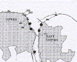
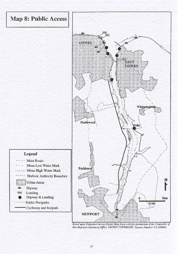
Public footpaths and the cycleway provide access along the estuary into the rural areas, see Map 8. On the eastern bank it is limited to footpath provision between Newport and the Folly Inn. This is regularly used by cyclists indicating the demand for the development of a cycle route on the eastern bank. The extension of the footpath to link the Folly Inn to East Cowes is desired to provide access all the way along the estuary between Newport and East Cowes.
| Objective R2 To improve the quality and provision of footpaths and cyclepaths. |
|---|
Facilities for yachtsmen visiting the Cowes and Newport Harbour authority moorings located within the harbours and at Folly Inn are inadequate. This was highlighted in the Cowes Visitor and Yachtsmen Survey (1994) which reported that the public shower and wash facilities in Cowes were the lowest rated aspect of the town.
Newport Harbour in January 2000 installed new pontoons along the Newport quay wall and is also aiming to improve the areas for winter yacht storage. The proposal to build a sill at Newport to retain water in the Harbour at low tide, is also being considered.
In Cowes, Town Quay re-development (2000) will improve the Red Jet Ferry Terminal, increase the size of the Yacht Haven and improve water front access in this area. East Cowes Marina is also seeing an improvement in its facilities for yachtsmen and there are proposed developments for Shepherds Wharf.
| Objective R3 To improve facilities for yachtsmen visiting Cowes and Newport Harbours and the Harbour Authorities moorings. |
|---|
2.8.2.2 Interaction between estuary users
Recreational users in general co-exist with other users and with each other. However, there are instances of local conflict. They include conflict with:
• commercial interests when recreational users are unaware of the manoeuvring characteristics and operational limitations of large commercial craft;
• landowners and farmers due to trespass into areas which are not part of the public rights of way network;
• nature conservation interests, for example, disturbance to birds, primarily caused by anglers, bait diggers, dog walkers and walkers; and
• other recreational users caused by the sharing of water space in narrow areas and cyclists using public footpaths.
The majority of the problems result from the actions of a small minority of users who are not fully aware of the implications of their actions on others or the natural environment. Voluntary regulation is flexible and allows for self policing and education at the local level. However, with the introduction of international nature conservation obligations, the development of byelaws or legislation may be necessary if voluntary management is not successful in reducing conflict.
| Objective R4 To promote the responsible use of the estuary as a recreational resource while minimising the conflict with and between other users and interests. |
|---|
2.8.2.3 Water Quality
Water quality is primarily of concern to recreational users involved in water borne activities. Concerns relate to possible health problems resulting from contact with sewage effluent disposed into the estuary and the odour and visual impact of the disposal of effluent and sludge.
| Objective R5 To improve the water quality of the estuary. |
|---|
Objectives and recommendations relevant to water quality are listed in more detail in the Water Management section (2.9)
Map 7: Recreational Provision
Click here to see the whole map
Map 8: Public Access
Click here to see the whole map
Click here to see the Recreation and Leisure Action Plan
Page last updated on: 19/09/2001