


The Western Yar estuary is situated in the north-western corner of the Isle of Wight. To the east is the town of Yarmouth, to the west is Norton and the southern boundary is marked by Freshwater, Freshwater Bay and Afton marshes. The estuary valley is predominantly rural and shows evidence of a long history of agriculture. It of great significance for nature conservation and the majority is designated as a Site of Special Scientific Interest (SSSI). The estuary is also included within the Island’s Area of Outstanding Natural Beauty (AONB), which has similar status to a National Park and is part of the Solent European Marine Site.
| Minimal estuary-side development and careful management by private landowners has helped to maintain the integrity and diversity of the habitats. There are a number of important semi-natural woodlands in the surrounding area including Saltern Wood, Backetts Copse, Mill Copse and Thorley Copse. The estuary is also of significant interest for migratory waders and wildfowl. Of particular interest are the dark-bellied Brent geese and the large flocks of overwintering teal and wigeon, though many other species such as curlew and redshank are regular visitors. | 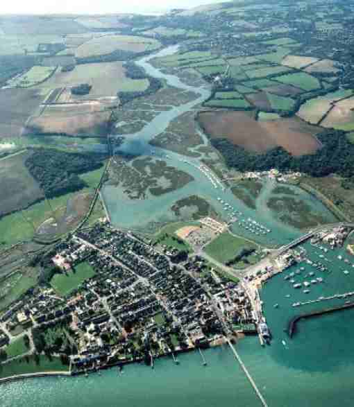 |
Resident fish species include mullet and flounder and although there is little fishing activity within the estuary, its relatively shallow sheltered waters are thought to be an important nursery ground for a variety of commercially important species.
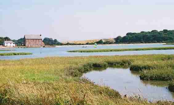 | The saltmarshes are relatively young, having developed since the 19th Century. Despite this they are botanically rich and contain at least two nationally scarce species of plant. The distribution and species diversity of the saltmarshes changes and evolves however there is concern throughout the region over the loss and erosion of saltmarsh habitat. |
It is likely that a number of processes have combined to cause this retreat of the saltmarsh including slumping of banks and steep slopes adjacent to the main navigation channel, natural "die back" of Spartina (an important salt-marsh plant), organic pollution and increased sedimentation.
The health of many of the landforms and habitats within the estuary is largely dependant upon the maintenance of physical processes. Norton Spit, Sandhard Creek, sand dunes, freshwater marsh, and the distribution of saltmarsh are all sensitive to changes in physical processes. The estuary’s main defence from the sea is Norton Spit which extends eastwards across the mouth of the estuary. The spit effectively encloses the Harbour and supports associated coastal defences including timber breastwork, timber groynes and a rock armour breakwater. At the end of the spit is a small sand dune system, one of only two on the Island. The sand dune system is mobile but sensitive to erosion from the sea and from human activity.
The health of many of the landforms and habitats within the estuary is largely dependant upon the maintenance of physical processes. Norton Spit, Sandhard Creek, sand dunes, freshwater marsh, and the distribution of saltmarsh are all sensitive to changes in physical processes. The estuary’s main defence from the sea is Norton Spit which extends eastwards across the mouth of the estuary. The spit effectively encloses the Harbour and supports associated coastal defences including timber breastwork, timber groynes and a rock armour breakwater. At the end of the spit is a small sand dune system, one of only two on the Island. The sand dune system is mobile but sensitive to erosion from the sea and from human activity.
| The Western Yar estuary is a valuable resource for the local community and visitors. It is widely used for a variety of recreational activities from walking and birdwatching to sailing and fishing. The proximity of the estuary to the Solent means it is a popular location for visiting yachtsmen and a number of local clubs and organisations use its sheltered waters. | 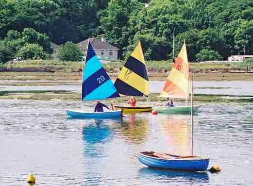 |
The estuary benefits from having a circular footpath around it which follows a former railway line along its eastern shore, crosses the estuary at the Causeway and then follows field boundaries on the higher ground to the west. The estuary walk is well way-marked and there are several connections with the Island Rights of Way network.
The Harbour Master manages water-based recreation activity and enforces the 4 knot speed limit within the estuary. Sport angling takes place on Yarmouth pier and along the seafront. Angling and bait digging in the Harbour are controlled under byelaw and within the estuary, angling requires access across private land.
The natural assets of the area are complemented by a range of high quality facilities which include a wide range of marine services available in the harbour, the town and Saltern Quay.
For more information about the Western Yar see the Western Yar Estuary Management Plan.
The Historic Environment
Yarmouth is one of the oldest settlements on the Isle of Wight and is surrounded by features of historic interest. Yarmouth Castle was built by King Henry VIII in 1545 following raids by the French and in recognition of the possibility that the Island could become an invasion base for a foreign army. The Sandhouse in the harbour dates from 17th Century. It was used to store coloured sands from Alum Bay before their export to France for the glass making industry until the business ceased in 1850.
A bridge first replaced the ferry service across the estuary in 1860. The original bridge was a long timber structure that stretched from the Sandhard at Norton to the end of Bridge Street. It was a toll bridge until the1930s and the original toll house became the home of the Yarmouth Sailing Club. The current bridge was constructed in the 1980s and is opened regularly to allow the passage of vessels upstream.
The narrow shoreline at Yarmouth has a proven propensity to preserve medieval and Tudor midden material beneath its shingle. At Yarmouth Roads, seabed scatters of Roman and medieval pottery are evidence of the town's early maritime importance. The wreck of the Santa Lucia (AD 1567) demonstrates the preservative qualities of the seabed beneath the town's traditional anchorage.
Archaeological Interest
Information provided by the County Archaeological Service
In 1997 a report was published that called for the national record of coastal archaeology to be actively developed and enhanced. Such information would permit effective and appropriate management of the resource and lead to a better understanding of England’s development as a maritime nation. It was proposed that rapid coastal surveys should be undertaken in order to gain a national overview of the nature and scale of archaeological and historic sites and features in the coastal zone.
In 1998 English Heritage provided funding for a rapid coastal audit of the Island’s coastal archaeological sites to be undertaken by the Isle of Wight Archaeological Unit. The coastal audit was also to provide an important contribution to a European funded study called ‘Coastal Change, Climate and Instability’ which demonstrated ‘the value of using archaeological (palaeo-environmental) evidence to predict the nature, scale and pace of coastal change ’.
The following information is extracted from the coastal audit.
The Western Yar differs from the Medina estuary in that saltmarsh coverage is more extensive and the river margins are masked by tall reeds and grasses. Consequently features were not readily visible in the river banks and intertidal zone. This probably reflects why a smaller number of sites are recorded in the Western Yar than the other estuaries.
Several earthworks are visible in the marshland adjoining the Yar. In Thorley Marshes, a bank was recorded during the audit which possibly relates to a saltern complex shown on charts of 1759 and 1769. Also noted in this marsh was a low raised linear feature with ditch to the side, which resembles a causeway. The mill dam which cuts off Thorley Marshes survives and is used as a footpath. To the south of Mill Copse, another bank is shown on 1866 Ordnance Survey maps, crossing the mouth of Barnfield Marshes. The northern part of this bank survives, but the south western part has been incorporated into the later railway embankment. In the intertidal zone the bank is partly revetted by a double alignment of posts, with further alignments running diagonally across the mud in front of this. It is unclear whether these posts protected the earlier bank or the railway embankment.
Listed buildings within the area include All Saints Church, Freshwater (Grade II*) and St Swithin’s, Thorley (Grade II*). The mill at Yarmouth is Grade II listed. Yarmouth station house and platform survives to the east of the mill and World War II pillboxes are present at Freshwater Causeway, Afton and Blackbridge.
For further information about archaeology on the Isle of Wight contact the Isle of Wight Archaeological Service at 61 Clatterford Road, Carisbrooke, Newport, Isle of Wight, PO30 1NZ
For information about maritime archaeology in the Solent region visit the website of The Hampshire and Wight Trust for Maritime Archaeology.
Page last updated on: 08/10/2001