


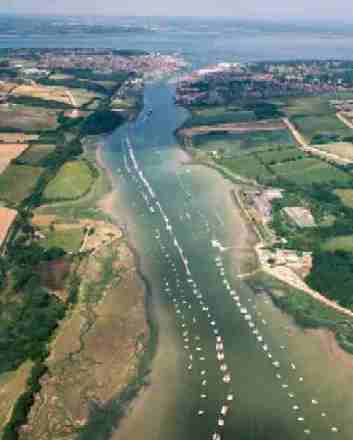
The Medina Estuary extends 6.8km from its tidal limit at Newport Harbour to the Solent at Cowes and East Cowes. It lies in a wide shallow valley with a gentle incline on either side and the build up of sediment has formed characteristic mudflats covering 66 hectares. The mudflats support a large number of species, including shellfish, algae and locally and regionally important species of worm. These are important sources of food for fish and bird populations. The estuary’s shoreline is approximately 14.4km and at low water a single, relatively wide but shallow channel remains.
| The middle and upper reaches of the Medina are largely bordered by agricultural land, hedgerows and woods. In contrast the mouth of the estuary and its lower reaches are lined by docks, boatyards and marinas. The diversity of the Medina and surrounding area provides numerous habitats that support a wide range of species and form an excellent environment for large numbers of wintering waterfowl and wading birds. |
| The importance of the Medina for nature conservation is reflected in the various tiers of designation at international, national and local level. Such protection ensures full consultation occurs prior to plans and proposals in order to prevent an adverse impact on the resource. |  |
Commercial and economic use of the estuary includes commercial shipping, ferry services, marine services, commercial fishing; and tourism. It is the only location on the Island which handles bulk cargo and although this trade has declined it continues to handle approximately 600,000 tonnes of cargo per year. The estuary supports a wide range of services including boat building and repair, sailmakers, engineers, chandlers and mooring facilities. The main location for these activities is Cowes but there are also support services based in Newport and at Island Harbour.
Cowes enjoys an international reputation as the home of yachting and its historical significance and profile help to attract new industry and international events to the Island. This contributes significant income to the Island, particularly through tourism.
Cowes Harbour Commission (CHC) and Newport Harbour Authority (NHA) have statutory responsibility for conservation and navigation within the estuary and have the powers to make byelaws for regulation purposes. The Harbour Authorities are also responsible for providing licences for dredging and navigational licences for oyster dredging within the estuary. Commercial fishing in the Solent is regulated by the Southern Sea Fisheries Committee (SSFC). The SSFC regulate inshore fishing via the implementation of byelaws. The Isle of Wight Council is responsible for planning and development control on the land to the mean low water mark offshore and within the whole of the estuary.
For more information about the Medina see the Medina Estuary Management Plan.
The Medina Valley Centre website also contains a large amount of information about the Medina, including fieldwork data and information about recent industrial developments.
Historical interest
Historically, the Medina has played a significant role in the development of the Island’s economy and its past is partially revealed by archaeological evidence.
Information provided by the County Archaeological Service
In 1997 a report was published that called for the national record of coastal archaeology to be actively developed and enhanced. Such information would permit effective and appropriate management of the resource and lead to a better understanding of England’s development as a maritime nation. It was proposed that rapid coastal surveys should be undertaken in order to gain a national overview of the nature and scale of archaeological and historic sites and features in the coastal zone.
In 1998 English Heritage provided funding for a rapid coastal audit of the Island’s coastal archaeological sites to be undertaken by the Isle of Wight Archaeological Unit. The coastal audit was also to provide an important contribution to a European funded study called ‘Coastal Change, Climate and Instability’ which demonstrated ‘the value of using archaeological (palaeo-environmental) evidence to predict the nature, scale and pace of coastal change ’.
The following information is extracted from the coastal audit.
The Medina
Erosion of the banks and saltmarshes adjacent to the estuary is variable but is occurring predominantly within the upper and middle reaches of the estuary. Some sites are known to have been receding progressively since the 1940s. Preliminary examination of aerial photography indicates approximate losses of between 5 and 17 metres since the mid to late 1960s.
Prehistoric activity was first noted in the Medina Estuary in the early twentieth century when hearths associated with late Mesolithic/early Neolithic flintwork were found during brickmaking operations at Werrar. Numerous hearths were noted in the face of the eroding river bank during the coastal audit but they were generally not associated with easily dateable material. Although it is assumed that they are of prehistoric date, both in the Medina and the Newtown estuaries they are often found in locations where later industrial activities such as brick or saltmaking also took place, so confirmation of the date of a selection of such features is required.
A scatter of prehistoric implements has been found along the length of the river, including a Palaeolithic handaxe at Wight Marina and numerous picks and tranchet axes. The Roman period is represented by numerous finds of coins in the intertidal muds and various finds of Roman pottery.
Fieldwork during the coastal audit identified post alignments and groups in the intertidal mud of the Medina, including a concentration of such features to the south of Kingston Power Station. It is not known how old they are or whether they are all contemporary.
Twenty hulks are recorded from the Medina. Most of these were originally identified on aerial photographs and later visited during fieldwork. Some vessels which were seen on aerial photographs are no longer visible – in some cases reclamation work along the river’s edge appears to have buried them.
The sites of seven brickworks are found along the river Medina below Newport. Tide mills were present on both the east and west sides of the river, and there s documentary evidence for two further mills near Newport Quay. The site of the West Medina mill is now occupied by a cement works which is itself an important industrial site.
At Newport there are nine listed buildings near the quay. The Quay itself is a stone structure with an adjacent slipway. A comparison with the Ordnance Survey map of 1862 shows the Quay to have been truncated when the railway was built. The original extent of the Quay was apparent some years ago when the increased force of water caused by heavy rain scoured out the river bed in this area. The harbour area of Newport has gradually extended with the construction of new quays and a hand crane remains on Seaclose Quay. Second World War air raid shelters are located at Newport Harbour and Medham.
For further information about Archaeology on the Isle of Wight contact the Isle of Wight Archaeological Service at 61 Clatterford Road, Carisbrooke, Newport, Isle of Wight, PO30 1NZ
For information about maritime archaeology in the Solent region visit the website of The Hampshire and Wight Trust for Maritime Archaeology.
Page last updated on: 08/10/2001