


| WALKING FROM NITON AND WHITWELL |
| |
| |
| |
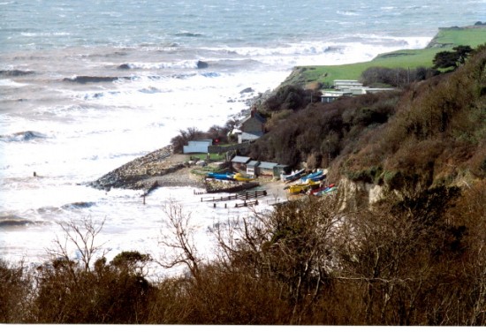 |
| Castle Haven photograph by Mr M Cooper To view a larger image click here |
| |
| |
| |
| |
| The parish of Niton is situated on the most southerly point of the island and together with Whitwell offers a range of coastal and downland walks within some of the islands finest scenery. |
| |
| Niton is the source of the River Yar, and the area has AONB status (Area of Outstanding Natural Beauty). The coastline is a designated Heritage Coast and the Undercliff SSI (Site of Special Scientific Interest). |
| |
| |
| |
| |
| Definitive Map |
| |
| The Definitive Map is a good starting point for any island walk. This map includes all public rights of way for which the Isle of Wight Council has a duty to maintain under the Wildlife and Countryside Act 1981. |
| |
| To access the Definitive Map click here |
| |
| Before embarking on any walk, especially those along a coastline it is advisable to check to make sure that the path in question is not subject to a closure order. Due to coastal erosion several paths in Niton and Whitwell parish are temporarily closed. |
| |
| For a list of footpath closures for the island including those for Niton and Whitwell click here |
| |
| |
| |
| |
| The Countryside Code |
| |
| Remember to follow the Countryside Code |
| |
| "Respect – Protect – Enjoy” |
| |
| Be safe Plan ahead and follow any signs |
| |
| Leave gates and property as you find them |
| |
| Protect plants and animals – take your litter home |
| |
| Keep dogs under close control |
| |
| Consider other people |
| |
| |
| |
| |
| Some walks you might enjoy |
| |
| Listed below are several island walks, which you might enjoy either as complete walks or in sections. Directions for all of these walks appear on various web sites to access a map and leaflet please click on the relevant link. |
| |
| |
| |
| |
| Over Undercliff and Up Downs |
| |
| The Isle of Wight Council AONB Partnership |
| |
| A 5 mile circular walk commencing and finishing at Blackgang View Point car park taking in Niton - Head Down - St. Catherine’s Down - Hoy Monument and St. Catherine’s Oratory. Approximate time to complete walk 3 to 3½ hours |
| |
| For a leaflet for this walk click here |
| For a map of this walk click here |
| |
| |
| |
| |
| Worsleys, Wyverns and Appuldurcombe |
| |
| The Isle of Wight Council AONB Partnership |
| |
| Although most of this walk covers the parish of Godshill, it can be easily accessed from Whitwell from the High Street via Nettlecombe Lane to Stenbury Down To access the relevant page from the Definitive map showing route options to Stenbury Down click here |
| |
| 6 mile walk commencing the Old Smithy car park Godshill – Godshill Church – Sainham Wood – Gatcliff – Stenbury Down – Appuldurcombe House – Godshill Approximate time to complete walk 4 hours + additional time if walking from Whitwell |
| |
| For a leaflet for this walk click here |
| For a map of this walk click here |
| |
| |
| |
| |
| The Monk and The Merchant |
| |
| The National Trust |
| A 4.8 mile walk commencing and finishing at Blackgang View Point Car Park, taking in St Catherine’s Down - Hoy Monument - The Hermitage - Wydcombe and St Catherine’s Oratory. Approximate time to complete walk 2 to 2½ hours |
| |
| For a leaflet and map for this walk click here |
| |
| |
| |
| The River Yar Trail - Source to Sea |
| |
| A walk of approximately 19 miles commencing at Niton and taking in Whitwell – Godshill – Horringford – Sandown – Brading – The Duver St Helens. Approximate time to complete walk 7¼ hrs |
| |
| For a leaflet, map and to view photographs for this walk click here |
| |
| |
| |
| |
| Isle of Wight Coastal Walk |
| |
| 14 Walks around the islands coastline ranging from 5 miles to 15 miles in length covering 67 miles in total. |
| |
| Walk 3 Brighstone to Niton 8 miles To access this walk click here |
| |
| Walk 4 Niton to Sandown 9 miles To access this walk click here |
| |
| To access all 14 walks click here |
| |
| |
| |
| |
| Isle of Wight Walking Festival 8th – 23rd May 2010 |
| and |
| Autumn Walking Weekend 22nd – 25th October 2010 |
| |
| To access the official site for information on all walks click here |
| |
| |
| |
| |
| To illustrate that Tourism and Walking are not new the following walk was found in “A Guide to the Isle of Wight” by the Rev. Edmund Venables, published in 1860. |
| |
| |
| Walk to Whitwell &c There is a pleasant walk across the fields by the source of the Yar to Whitwell; where, if we take the lane which leads to Nettlecombe at the bottom of the village, and turn speedily to the left, the old manor-house of Stenbury may be reached, whence we may ramble across the fields by Ford Mill to Whitcombe, and thence return to Niton. |
| |
| |
| |
Page last updated on: 23/04/2010