PURPOSE/REASON
1.
The
Council, as registration authority, has received an application to register the
Esplanade and land to the south at Gurnard as town or village green under
Section 13 of the Commons Registration Act 1965 and Regulation 3 of the
Commons Registration (New Land) Regulations 1969. The 1969 Regulations came into force on 3 January 1970 and
Regulation 3 enables the making of an application where, in accordance with
Section 22 of the 1965 Act, after 2 January 1970 any land becomes a town or
village green. The application is
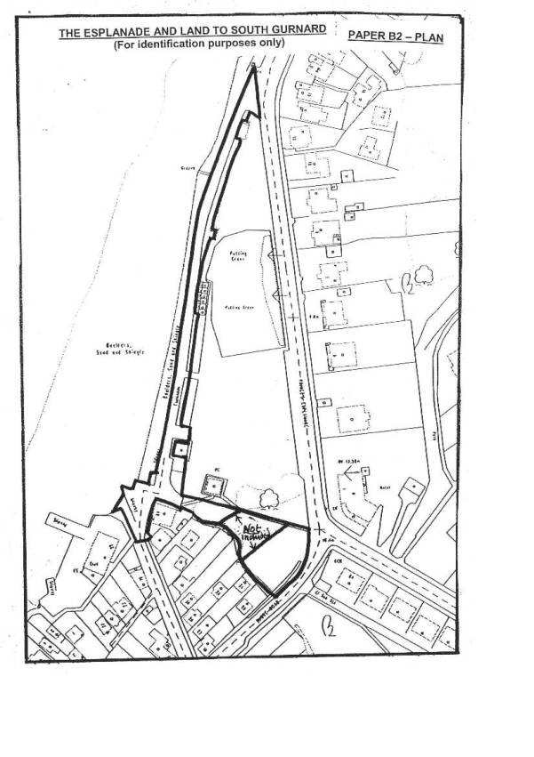
brought before the Committee for decision.
BACKGROUND INFORMATION
2.
The application,
which relates to the Esplanade and land to the south is the second of three
village green applications made by Mrs Elizabeth Campbell of Wardwicke
Cottage, Baring Road, Gurnard, Cowes, for the registration of land at Gurnard.
3.
The Applicant has
expressed disquiet about possible inaccuracies on the Council’s Register
Map. She has done a great deal of
research and is very knowledgeable about the history of Gurnard Green (also
known as Woodvale Green). It is the
Applicant's view that part of the land she is seeking to register should have
been registered under the original 1965 exercise. The suggestion is that an error was made when transferring
details of the Register Unit VG14 from the application plan to the Register Map
in 1977. The Council does not have any
of the original 1968 application documents and is unable to prove or disprove
this theory. In any event the Council,
as the registration authority, has no powers under the 1965 Act to correct
clerical errors or omissions even if these were proved to exist.
4.
The Applicant is seeking to register what she believes
should have been registered under the original exercise. The land is held by the Council for public
recreation (see paragraphs 13 and 14 below) and the applicant’s objective
is to seek the additional protection of the 1965 Act to prevent any
encroachment on or Interference with the land.
5.
The members of Gurnard Sailing Club, which is a local
dinghy club supported by lottery funding, have expressed considerable concern
about this application which includes an area of land used by the Club for the
storage of dinghies. They point out
that registration of this land would prohibit use for dinghy parking leading to
a severe curtailment of the Club’s ability to provide for its sailing
activities which could lead to loss of members and potentially the demise of
the Club.
6.
Members are reminded that although they may sympathise
with the Applicant's intentions and the Sailing Club’s concerns, each application
has to be determined on the evidence and legal issues alone. If the application satisfies the relevant
statutory requirements then the Council may accept the application but, if the
statutory requirements are not satisfied, the Council has no option but to
reject the application.
DETAILS OF APPLICATION
7.
The
application is made under Section 22 of the 1965 Act that the land has become a
village green because it has been used by local inhabitants for lawful sports
and pastimes as of right for not less than twenty years. The claim has been lodged on the basis that
the land has been used for recreation by the inhabitants of Gurnard without
force, without secrecy and without permission for the period 1970 to 1990 and
that use is continuing.
8.
The Applicant has submitted twenty statements and two supplementary
letters in support of her three separate Gurnard applications. The supporting statements are in the form of
completed questionnaires and are summarised at Appendix
B1 (column 2 of the summary indicates to which application(s) the
respective statements refer). Ten of
these statements relate to the land the subject of this application. In addition, various photographs and press
cuttings are submitted as evidence.
9.
A folder (marked ‘Folder 1’) containing a copy of the application
together with full copies of the statements and documents submitted by the
Applicant is provided for the Committee Members and a copy has also been placed
in the Members’ Room at County Hall for ease of reference. A further copy is available for public
inspection at the Customer Services Centre, County Hall.
LOCATION
AND SITE CHARACTERISTICS
10.
The application land is shown for identification only edged with a thick
black line on the plan annexed to this report.
For the purpose of this report, the land is identified as two separate
areas marked area “A”, and “B” respectively.
A colour copy of the original application plan is included in the
documents in ‘Folder 1’ (page 32).
11.
Area “A”
Area “A” comprises the promenade
on the west side of Gurnard Green known as The Esplanade and a slipway area to
the south.
The Esplanade is a hard surfaced walkway which adjoins the sea wall and
runs the whole length of Gurnard Green.
It also includes a paved patio area to the front of the beach huts which
back onto the green.
The “slipway area” comprises a small stretch of tarmac with some
painted double yellow lines and a hard surfaced slipway extending seawards
which provides access to the beach.
12.
Area “B”
Area
“B” comprises two sections with an overall area of
approximately 787 square metres. They
form either end of a triangular shaped piece of land, the wider section adjoining
Shore Road, sloping east and narrowing at the end where it adjoins the slipway
area to the Esplanade. The central area of the triangle is the subject of a
1986 lease to Gurnard Sailing Club and is not included in the application.
The greater part of Area “B” is made up of rough grass with a number
of mature oak trees. Some areas of the
land have been concreted. The southern boundary is marked by a narrow winding
stream that is spanned by several small wooden bridges to access residential
properties backing onto the land. The eastern and northern boundaries are
marked by a post and chain link fence with an un-gated opening at the Shore
Road end. The narrow west end is a hard
surfaced area with an ungated opening onto the Esplanade and slipway.
RELEVANT
HISTORY
13.
Area A
The Esplanade (excluding the “slipway area”) forms the most western
strip of the area of land purchased in January 1925 by Cowes Urban District
Council under Section 164 of the Public Health Act 1875. Following its acquisition in 1925 it was
laid out by the Urban District Council for public recreation and has been
maintained as such by Isle of Wight Council and its predecessor local authority
owners.
The paved patio to the front of the beach huts was constructed in
about 1990 by Medina Borough Council as part of an improvement programme for
the area.
The “slipway area” to the south was purchased by the Urban District
Council in June 1925 under Section 175 of the 1875 Act.
In 1998 the responsibility for maintenance of the tarmac area on the
landward side of the slipway was passed from Leisure and Cultural Services to
the Highways Department although it is not part of the adopted highway.
14.
Area B
Area “B” is the southern most part
of the land acquired by Cowes Urban District Council in January 1925 for the
purposes of public recreation.
In 1986, Medina Borough Council
leased the central section of this land to Gurnard Sailing Club and hence this
section has not been included in the application. In 1989, the Borough Council agreed to extend the 1986 lease (of
the middle area) to take in additional land to the west and east (Area “B”).
The Sailing Club was then permitted to occupy this additional land as a dinghy
park pending negotiations and completion of a formal lease.
Following Local Government
Reorganisation in 1995, the Isle of Wight Council, as the successor authority,
continued the negotiations for the lease. During the course of these
negotiations, the Sailing Club obtained significant grant funding to commission
a new clubhouse. As a result, its
membership increased and it sought a longer term lease to allow it to enhance
and upgrade the dinghy park. The
negotiations for the proposed new lease have not yet been concluded and, in the
meantime, the Sailing Club has continued in occupation of Area “B” which it
uses for the storage of dinghies.
FORMAL
CONSULTATION
Advertisement
15.
In accordance with the requirements of the 1965 Act and the 1969
Regulations the application was advertised by notices placed on site and in the
County Press. Copies of the application
and supporting documents were made available for public inspection at the
Customer Services Centre in County Hall and at Cowes Library.
Relevant Council Departments
16.
Notice
of the application was sent to Property Services, Planning Services Community
and Development (Parks and Beaches) and Countryside Services.
Parish and Town Councils
17.
Notice
of the application was sent to Gurnard Parish Council. The Parish Council object to the proposed
registration on the grounds that the land has not been used as of right.
Local Member
18.
Notice
of the application was sent to Councillor A J Mundy.
THIRD PARY REPRESENTATIONS
Objections
19.
Following advertisement of the three Gurnard applications, the Council
received nineteen letters of objection, fourteen of which relate to this
application. The letters of objection
are summarised at Appendix B2 (column 2 of the
summary indicates to which application(s) the respective letters refer).
20.
Copies of the letters of objection were sent to the Applicant for
comment. The Applicant sought the
advice of the Open Space Society and Alec Samuels (former legal advisor to the
Open Spaces Society) in her response. A
draft Committee report was then prepared and the Applicant and, where
appropriate, those objectors with a proprietary interest in the land were
invited to comment on the draft report.
21.
A folder (marked ‘Folder 2’) containing full copies of the letters of
objection and the Applicant’s response together with supplementary comments is
provided for Committee Members. A copy
has also been placed in the Members Room at County Hall and a further copy is
available for public inspection at the Customer Services Centre, County Hall.
22.
The pertinent objections and the Applicant’s response thereto together
with any relevant supplementary comments have been evaluated under the relevant
headings in paragraphs 34 to 75
(inclusive) below.
Supporters
23.
The application has been supported by the ten completed questionnaire
statements referred to in paragraph 8 above and summarised at Appendix B1. This evidence has been evaluated in
paragraphs 34 to 75 (inclusive) below.
FINANCIAL IMPLICATIONS
24.
The
land the subject of this application is owned and maintained by the Council for
recreational use and there will be no further financial implications in this
respect.
25.
If the
Committee decides to seek independent expert advice, the cost of referring the application to Counsel could be between
£1,000 and £5,000 (depending on complexity) and the cost of a non-statutory
public inquiry could be between £15,000-£20,000 (depending on length and number
of witnesses). There is no allocation
in the budget for this.
LEGAL IMPLICATIONS
26.
The
Legal implications of registration is set out in paragraphs 29 and 30 of
Paper A.
IMPLICATIONS UNDER THE CRIME AND
DISORDER ACT 1998
27.
It
is not anticipated that the options placed before the Committee will have any
implications under the Crime and Disorder Act 1998.
IMPLICATIONS UNDER THE HUMAN
RIGHTS ACT 1998
28.
The
potential implications under the Human Rights Act 1998 are summarised in
paragraph 39 and 44 (inclusive) of Paper A.
29.
The
Applicant refers to Article 6 of the 1998 Act (right to a fair hearing)
commenting that the Council should not determine an application relating to its
own land without independent expert advice.
She has therefore requested that the application be referred to a
non-statutory inquiry.
30.
It is
accepted that where there is a serious factual dispute it would be appropriate
to hold an independent inquiry before making a decision. However, the evidence in this application is
not generally in dispute. The issues
can be determined by reference to case law and statute. It does not matter that the Council is also
the landowner. If the decision is wrong
in law the applicant has sufficient safeguard in having the option to seek a
Judicial Review. There would be no
benefit or justification in referring the matter for independent report.
OPTIONS
31.
(a) To accept the application and register
the subject land as a town or village green.
(b) To reject the application
on the grounds that the land does not satisfy the statutory requirements for
registration.
(c) To appoint an
independent inspector to consider the evidence or hold a non-statutory public
inquiry to hear the evidence and make a recommendation to the Committee.
EVALUATION/RISK
MANAGEMENT
32.
All
the evidence and representations submitted in support of the application and
the objections to the registration have been assessed and evaluated with
reference to current statute and case law in the preparation of this report.
APPLICATION
33.
The stated ground for the application
is that the land has become a village green by virtue of its use (1) by local
inhabitants (2) for lawful sports and pastimes (3) as of right (4) for not less
than twenty years. For the application
to succeed the Applicant must prove her case in all four parts of the stated
ground. Each part is considered in turn:
(1) LOCAL INHABITANTS
Applicant’s evidence
34.
The local inhabitants are the residents
of Gurnard. The Applicant refers to the
statements submitted in support of her application (see paragraph 8 above and
Appendix B1). Of the ten statements
relating to this application, six have been completed by local residents. The remaining four are from residents of
Cowes (2) and Newport (2) although two of these originally lived in Gurnard and
have continued to visit and use the land after moving away.
35.
All the statements confirm that the
land was used by the residents of Gurnard, their families and friends.
Objections
36.
The pertinent objections are
summarised as follows:
(a)
The Esplanade and slipway (Area ‘A’)
is owned and maintained by the Council for use by the public at large. The provision of deck chair concessions and beach
huts would attract visitors and holidaymakers to the area. The use of this land has been by the general
public and not primarily local inhabitants.
The supporting statements confirm use by other Island residents together
with tourists and visitors on holiday from the mainland.
(b)
The land to the south (Area ‘B’) has
been occupied and used by Gurnard Sailing Club for a dinghy storage area during
part of the relevant period. The use of
this land has therefore been by club members (some of whom are resident in
Gurnard) and visiting dinghy sailors not by local inhabitants.
37.
The Applicant’s response to the
objections are summarised as follows:
(a)
Use of the land by people outside the
locality would not automatically defeat the claim. It only has to be shown that there has been general use of the
land by the inhabitants of a locality.
(b)
The evidence in the statements show
that a significant number of residents of Gurnard use the land for
recreation. The Sailing Club are mainly
residents of Gurnard.
(c)
Previous decisions to refuse
registration on the grounds that the land was also used by the public has been
overturned by the “Sunningwell” case.
Use by people other than local inhabitants does not prevent registration
as a village green.
(d)
It is now only necessary to show that
the land has been used by a significant number of local inhabitants. The evidence of the questionnaire statements
is sufficient to indicate that the land is in general, used by the inhabitants
of Gurnard.
Comments
38.
The land was acquired under Section
164 of the Public Health Act 1875 for public recreation. The Council has provided facilities which
would attract people from outside the immediate locality. However, a large number of those using the
area will be those from the surrounding neighbourhood. During the winter months
in particular the use would predominantly be by local inhabitants.
39.
The land to the south (Area “B”) has
not been maintained to the same extent as the remaining green and, prior to its
use by the Sailing Club, was generally a rough grassy area with trees and some
undergrowth. This area would be
unlikely to be used by the general public but would be attractive for
children’s play, as claimed in the questionnaire statements.
40.
Common sense would recognise that a person
who resides in the locality of the land in question will be a local
inhabitant. Under Section 22 of the
1965 Act (as amended), it is not necessary to define the locality more closely
than Gurnard.
41.
It is clear, from the information
contained in statement questionnaires, that the land the subject of this
application has been used by the residents of Gurnard. It has also been used by Island residents
outside the locality together with tourists and visiting dinghy sailors,
particularly during the summer months.
However, it is to be expected that a substantial number of those using
the land would be from the surrounding neighbourhood.
Relevant Case Law
42.
R v Oxfordshire County Council Ex
Parte Sunningwell Parish Council (1999)
It was held that provided there is sufficient evidence to show the use is
predominantly by local inhabitants, the fact that the land is also used by the
public will not defeat the claim.
43.
R v Staffordshire County Council Ex
Part McAlpine Homes (2002)
It was held that it only has to be shown that the land is in general use by the
local community for informal recreation.
“Significant” does not have to be a considerable number.
Issues Arising
44.
That the local inhabitants used the
application land is not an issue. The
evidence of the questionnaire statements on this point is not disputed. It is accepted a significant number of those
using the land were inhabitants of Gurnard and that Gurnard is a locality for
the purposes of S22 of the 1965 Act as amended.
45.
The question is one of law. Does the use by visitors to the area defeat
the claim of use by local inhabitants?
Conclusion
46.
Referring to the case law above, it is
concluded that the requirements of Section 22 (as amended) are satisfied as
regards use by local inhabitants.
(2) LAWFUL SPORTS AND PASTIMES
Applicant’s evidence
47.
The Applicant relies on the
information contained in the completed questionnaire statements, supplementary
letters and the photographs submitted in support as evidence of the use of the land
for lawful sports and pastimes. The ten
statements relating to this application identify a variety of activities as
listed in columns 5 and 6 of the summary in Appendix B1.
48.
The statements refer to sunbathing and
picnics outside the beach huts and watching the yachts and regatta activities
from the Esplanade and slipway (Area “A”).
This is supported by photographs taken in the 1980’s of people
relaxing/sunbathing along the Esplanade and sitting on the sea wall. Most of
the other photographs of the Esplanade pre-date the relevant application
period. Other activities such as dog walking, strolling and socialising are
also mentioned.
49.
The statements and supplementary
letters describe the land to the south (Area “B”) as an area for children to
play and picnic. They detail specific activities such as tree climbing,
“plodging” in the stream and “pooh sticks”. An undated photograph (annexed to
questionnaire 16) also shows children tobogganing on this land.
Objections
50.
There were no specific objections to
the activities claimed to have been enjoyed over the land.
Relevant Case Law
51.
Staffordshire County Council Ex
Parte Sunningwell Parish Council (1999)
Held : Informal modern activities such as dog walking and children’s
play as well as traditional ones are relevant for the purposes of registration.
Issues Arising
52.
There is no dispute about the fact
that certain activities took place over the land. The issue is one of law.
The question being whether the types or activities claimed constitute lawful
sports and pastimes for the purposes of the 1965 Act.
Conclusion
53.
With reference to the above case
law it is concluded that the recreational
activities claimed to have been enjoyed on Area ‘A’ and ‘B’ of the application
land would constitute lawful sports and pastimes for the purposes of the 1965
Act.
(3) AS OF RIGHT
Applicant’s evidence
54.
The Applicant refers to the statements
in support of her application. Five of
the statements relating to this application state that no permission was sought
and the use was not prevented. One
refers to it being public land. Three of the statements mention that use was
interrupted by the recent Seaclean Wight works (Area “A”) and one of these plus
two others comment that the use was prevented by the Sailing Club dinghy park.
(Area “B”).
55.
The Applicant submits that the land
was acquired as open space and the local inhabitants used the land for
recreation as of right. There were no
signs or barriers erected on the Esplanade or Slipway area to prohibit or
prevent the use of the land for recreation.
The land has been used without force, without secrecy and without
permission. The residents of Gurnard who used the land genuinely believed that
they could do so as of right.
Objections
The pertinent objections are summarised
as follows:
56.
(a) The
land the subject of the application was acquired by the Council for the
purposes of public recreation under the Public Health Act 1875. The Council holds the land for public use which
prevents the accrual of prescriptive rights therefore any use of the land
cannot be “as of right”.
(b) With regard to Area ‘B’, this area of land has been used by
Gurnard Sailing Club as a dinghy park.
Fences were erected and notices placed on site to the effect that the
land was for use by the members of the Sailing Club. Any person using the land would be aware the Sailing Club was in
occupation of the land.
57.
The Applicant’s response to the
objections is summarised as follows:
(a)
Land owned by a Local Authority can be
registered as Village Green and the designation of land as public open space
does not inhibit a claim for registration.
The adjoining land was registered as Village Green in 1970. This was
also part of the land comprised in the 1925 conveyance and its acquisition
under the 1875 Act did not prevent its registration.
(b)
The general public has the right to
use the land for recreation under the Public Health Act 1875 and the local
inhabitants have used the land as a Village Green as of right under the 1965
Act.
(c)
The Applicant refers to village green
status granted in 2002 to Clayton Playing Fields in Royton Oldham
Manchester. A deed of gift granted
permission for formal sports but the deed gave no permission for informal activities. Arguments were raised about implied
permission but the application was successful.
(d)
With regard to the land to the south
(Area “B”) the Applicant does not dispute that a fence was erected by Gurnard
Sailing Club or that dinghies were stored on the land. However this land was accessible to the
public through ungated openings in the fence at the eastern and western
ends. The only notice was to indicate
that the land was used by the Sailing Club for the storage of dinghies. There was no notice specifically prohibiting
the public from using the land for recreation. Children could freely go on to
the land to play and had not been prevented from so doing.
Comments
58.
The application land was acquired by
the Council under the Public Health Act 1875.
The slipway area was acquired under Section 175 of the 1875 Act which
gives local authorities a general power to acquire land for public health
purposes. The remaining land was
acquired under Section 164 of the 1985 Act for the purposes of public
recreation. Accordingly use of the
land, for whatever purposes, is pursuant to the 1875 Act and is not “as of
right”.
59.
The 1875 Act authorises the enactment
of byelaws to control the use of the land.
The Council has power to regulate the conduct of the public on the land
and use of the land under this type of regulation cannot be “as of right”.
60.
The adjoining land comprising Unit
VG14 was registered under the original 1965 exercise which provided for
automatic registration where there were no objections (see Paper A paragraph
8). Therefore the legislation under
which the land was held was not an issue at the time. The current application is made to amend the Register to include
land that it is claimed has become a “new” village green since 1970 and
accordingly the requirements of Section 22 of the 1965 Act must be satisfied.
61.
The Council is not bound by the
successful Clayton Playing Fields registration referred to by the
Applicant. The land has been the
subject of two previous applications.
Both these applications, which were opposed and had the benefit of
Counsel’s opinion, were rejected. There
were no objections to the third application and Counsel’s opinion was not
sought. The decision to accept the
application was made by the Commons Registration Sub-Committee of Oldham MBC
against the recommendation of the Committee’s legal advisor. The land is held on trust by the Council and
the decision to grant village green status to the land is/was the subject of an
inquiry under Section 8 of the Charities Act.
Relevant Case Law
62.
Hall v Beckenham Corporation (1949)
The case related to a public nuisance in a Local Authority park acquired
under Section 164 of the Public Health Act 1875. One of the matters to be decided was the entitlement of the
public to use the park. It was held
that the Council was the trustee of the park and had no power to prevent use of
the park. This indicated that members
of the public were entitled to enter the park and thus do so by right under the
1875 Act and not “as of right”.
63.
R v Secretary of State for
Environment (Ex Parte Billson) (1998)
The case related to Ranmore Common.
The landowner made a deed under Section 193 of the Law of Property Act
1925 which allowed public access for air and exercise. The public used the land unaware of the
existence of the deed. It was held
that the public used the land by way of a licence (and therefore permission)
even although they were ignorant of the licence.
Relevant Commons Commissioners Decisions
64.
Harwich Green, Essex (1974)
Related to land acquired by the Local Authority in 1912 as public
walks and pleasure grounds under Section 164 of the Public Health Act
1875. It followed that use of the land
since its acquisition in 1912 was explained by the fact that it had been open
to the public under the 1875 Act.
65.
The Downs, Herne Bay, Kent (1980)
Related to two areas of land acquired by the Local Authority in 1881 and
1901 respectively as open space for the enjoyment of the residents and visitors
to Herne Bay. The whole of the land was
subject to by-laws made under Section 164 of the Public Health Act 1875. The use of the land by the inhabitants of
Herne Bay was by virtue of it being open to the public under the 1875 Act.
Issues
Arising
66.
It is accepted that Area ‘A’ has been
used openly and although Area ‘B’ was fenced, access could be gained through
ungated openings. The evidence is not
disputed. The issue is one of law. The question being whether use of the land
was “as of right”.
67.
It is concluded that the inhabitants of Gurnard together with the public generally
have used the land by virtue of the Public Health Act 1875. Therefore the use has not been as of right.
(4) NOT LESS THAN TWENTY YEARS
Applicant’s Evidence
68.
The Applicant refers to the statement
questionnaires relating to this application which cover the period 1940 to 2001
and continuing. The relevant twenty
year period for the purpose of this application is 1970 to 1990 and the
statements cover the whole of this period.
The frequency of that use varies between daily, weekly, monthly and
occasionally.
69.
The Esplanade and slipway (Area “A”)
has been available for use during the whole of the relevant period (1970 –
1990) and has continued to be available save for some interruption by safety
fencing to protect works connected with the Seaclean Wight Scheme.
Objections
70.
During the relevant twenty year period
Area ‘B’ was fenced by Gurnard Sailing Club for use as a dinghy park. Work was carried out to level the land and a
concrete driveway was constructed over a substantial length of both
sections. The use as a dinghy has
increased since the late 1980s. It was
consistently full between March and September and has a significant number of
dinghies parked on it during the winter months. The leveling works, fencing and storage of the dinghies would
have interrupted the twenty year qualifying period.
71.
The Applicant does not dispute that
dinghies were stored on this land from time to time but asserts that this was
mainly during the summer months and during regatta events. She submits that this dinghy storage would
not prevent children playing on the land or substantially interrupt that
play. It has been possible to use that
part of the land where dinghies are not parked particularly the area by the
stream. The intermittent storage of
dinghies through the year does not necessarily break the continuity of
use. No one expects that local
inhabitants should use the land every day for twenty four hours a day.
Comments
72.
The relevant twenty year period
claimed in the application is 1970 to 1990. It is necessary to show that the
inhabitants have indulged in lawful sports and pastimes over the land for the
whole period.
73.
The Esplanade and slipway area (Area
“A”) was available for use during the relevant twenty year period. However, it is questionable whether the full
twenty year period could be enjoyed in relation to the land to the south (Area
“B”) which was used for the storage of dinghies. It would not be possible for the lawful sports and pastimes
claimed to be enjoyed over that land occupied by the dinghies. It is clear that a significant part of the
land could not be used for the recreational use claimed for a large part of the
relevant period.
74.
It is accepted that the land would not
be used for recreational activities every day.
The use of a village green would be seasonal; more in summer and school
holidays and less in winter. There will
be days when no recreation takes place.
That does not matter. What is
important is that there is nothing that would prevent the lawful sports and
pastimes taking place on the land. If
cars, and likewise dinghies, are parked on the land this is an interruption of
any use of the land for sports and pastimes.
Issues Arising
75.
There is no dispute as to fact. It is accepted that Area ‘A’ was open and
accessible and that dinghies were parked on Area ‘B’. The issue is one of law.
The question being whether the parking of dinghies on the land
interrupted the use of that land for lawful sports and pastimes.
Conclusion
76.
It is concluded that the use of Area “A” has been enjoyed for the full twenty year
period but the use of “Area B” was interrupted during the relevant period by
the storage of dinghies.
RECOMMENDATIONS
77.
That the application be rejected on the
grounds that the legal requirements for registration have not been met,
specifically that the use of the land by the inhabitants of Gurnard has been
by virtue of the Public Health Act 1875 and not as of right.
78.
In addition, the land to the
south identified as Area “B” was not available for use during the whole of
the relevant twenty year period.
|
APPENDICES
ATTACHED
79.
Application Map
80.
Summary of Questionnaire Statements (Appendix B1)
81.
Summary of Objections (Appendix B2)
BACKGROUND
PAPERS
82.
Application and Supporting Documents.
83.
Objections and replies to objections.
84.
Supplementary comments from Applicant and Objectors
85.
Legislation
Public Health Act 1875
Commons Registration Act 1965
Commons Registration (New Land) Regulations 1969
The Human Rights Act 1998
The Countryside and Rights of Way Act 2000
86.
Case Law
Hall v Beckenham Corporation (1949) 1A11ER423
R
v Secretary of State for Environment Ex Parte Billson (1998) 2A11ER587
R v Oxfordshire County Council Ex Parte Sunningwell
Parish Council (1999) 3A11ER385(HL)
R v Staffordshire County
Council Ex Parte McAlpine Homes (2002) EW CH 76 (Admin)
87.
Commons Commissioners decisions
Harwich Green Essex (1974) (12/D/43)
The Downs, Herne Bay, Essex
(1980) (219/D/2)
Contact Point: Margaret Kirkman/Vivien Mann : F 3214/3209
M J A FISHER
Chief Executive Officer and
Strategic Director of Corporate Services