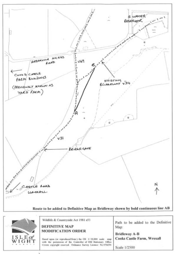
marked CB on the map climbs directly from V31 up a
steep bank covered with bracken and gorse scrub to an open grassy plateau at point
B. In September 1999 there was no
physical sign of CB through the vegetation, but a path was cleared and
waymarked in November 1999 in response to a request from the landowner.
1.4 Legal
advice on the determination of modification applications is set out at section
2 and at Appendix 2. User evidence is set out in section 3 and at Appendix 3,
landowner evidence at section 4 and at Appendix 4. Documentary evidence
consisting of aerial photographs is at section 5 and Appendix 5. Evaluation and
conclusions are set out in section 6.
Local member and parish council comments on the proposed modification,
if submitted, are at section 1.5 below and at Appendix 7. Final comments of the
landowner on this report are copied at Appendix 8 together with the Council’s
response.
1.5 OUTCOME
OF CONSULTATIONS
The Local
Member and the Parish Council have been consulted and their comments if
submitted are attached in Appendix 7.
The owner of
the land over which the route AB runs has been consulted. Evidence relating to or submitted by
previous or current landowners is in section 4 below.
2.
LEGAL BACKGROUND TO MODIFICATION ORDERS
Provisions
of Wildlife and Countryside Act 1981 section 53
2.1 Under
section 53 of the Wildlife and Countryside Act 1981 the Council as Surveying
Authority for the Isle of Wight has a duty to keep the Definitive Map and
Statement under continuous review by making modification orders when necessary
because of certain events specified in section 53 (3).
2.2 The
events specified in section 53(3)(a) are legal events such as diversion orders
under the Highways Act, for which an automatic map modification order not
requiring advertisement is made. The events specified in section 53(3)(b) and
(c) are those which require the Council to consider evidence relating to a
possible public right of way, or to anything currently recorded in the
Definitive Map and Statement. In this case the order is made according to the
procedure set out in Schedule 15 and must be advertised to allow a period of
public challenge and the possibility of a public inquiry or hearing to test the
evidence.
2.3 The
event specified in section 53(3)(b) is the expiration of any period of time
such that public enjoyment of the way gives rise to a presumption of dedication
of a public right of way.
2.4 The
event specified in section 53(3)(c) is the Council’s discovery of evidence
concerning a public right of way. An order should be made if on balance of
probability the evidence, when considered with all other relevant available
evidence, shows:
(i) that
a right of way which is not shown in the map and statement subsists, or is
reasonably alleged to subsist over land in the area to which the map relates,
being a right of way to which this part applies.
(ii) that
a highway shown in the map and statement as a highway of a particular
description ought to be there shown as a highway of a different description.
(iii) that
there is no public right of way over land shown in the map and statement as a
highway of any description, or any other particulars contained in the map and
statement require modification.
2.5 In the
case of the deletion of a right of way, because of the conclusive evidential effect of the Definitive Map and Statement (Wildlife and Countryside Act
1981 section 56), the evidence supporting a deletion must show that no right of
way existed at the relevant date
of the Definitive Map on which the
right of way was first shown. The onus is on the applicant to demonstrate that
an error has been made, rather than for the authority to prove that the
Definitive Map is correct. If the authority itself has evidence of an error, it
must similarly demonstrate the fact before making an order.
2.6 Under
section 53 paragraph (5) and according to the procedure set out in Schedule 14,
anyone may apply to the authority for a modification order required under (b)
or (c), that is, may bring evidence to
the attention of the authority. The authority is then under a duty to
investigate that evidence, to consult with other local authorities for the area
and then to determine whether to make the order. If this determination is not made within 12 months, the applicant
may apply to the Secretary of State, who, after consulting with the authority,
may direct the authority to do so.
2.7 If the
authority determines not to make the order, the applicant may appeal to the
Secretary of State, who may direct the authority to make the order.
2.8 If the
Council decides to make a modification order, it must be advertised for not
less than 42 days and if there are any objections which are not withdrawn, it must be referred to the Secretary of
State for determination and a public inquiry will usually be held.
Effect of
the Definitive Map
2.9 Under
section 56 of the Wildlife and Countryside Act 1981, the Definitive Map is
conclusive proof of the existence and status, at the relevant date of the map,
of the rights of way that are shown, but without prejudice to the possibility
that further rights may exist. The Definitive Statement is conclusive proof of
the details which it contains as to
width, position and any conditions or limitations on the rights of way shown on
the Definitive Map.
2.10 The
original Definitive Map and Statement for the Isle of Wight was made under the
National Parks and Access to the Countryside Act 1949 and has a relevant date
of 11 November 1952. It was reviewed under the same act with a relevant date of
8 February 1968. On both occasions it went through all the necessary stages
when challenges could be made. The advice of the Department of the Environment
is that such documents are presumed correct unless there is cogent evidence
that an error was made. The current
Definitive Map and Statement has a relevant date of 29 February 2000.
2.11 Dedication
of Highways
The question
which usually has to be determined by the Council when considering a
modification order is whether the evidence shows that a highway exists because
dedication has occurred at common law or is deemed by operation of section 31
of the Highways Act 1980. Where this question is a relevant issue, the
Department of the Environment’s guidance notes for inspectors on the dedication
of highways are copied in full at Appendix 2. Evidence concerning dedication
should be interpreted in the light of the principles set out, but note that the
advice there given is amended in the light of the Sunningwell decision in 1999
(see Planning Inspectorate Advice Note No 6 attached at Appendix 2) to the
effect that in deciding whether use is as of right, it is no longer necessary
to consider the belief of the users. It is only necessary to be satisfied that
use by the public was without force, without stealth, and without
permission.
2.13 Once
public rights are dedicated over a way, that way becomes a highway and exists
in perpetuity unless stopped up or diverted by statutory order. The highway does not cease to exist because
it is not used, hence the maxim ‘once a highway, always a highway’.
2.14 Quasi-Judicial
role of the Council
In
considering the evidence, the Council is acting as a tribunal of fact and is
required to:
1. Objectively
consider all the available relevant evidence, taking advice as to application
of legal principles where necessary, and come to a conclusion, on balance of
probability, on matters relating to the existence of public rights of way in
order to determine whether a modification of the Definitive Map and Statement
is required. Such matters may include whether a presumption of dedication is
raised, whether such a presumption is negated, whether a right of way subsists,
details relating to position and width, or to limits or conditions on a
dedication.
2. Disregard
all views which are not relevant to the fact which has to be found. Such views may concern for example the
effect or desirability of the right of way should it be found to exist.
3. Apply
the principles of natural justice. The decision itself will depend upon the
facts and law, but in making that decision it is important that persons who
will be affected by the order if made, notably the landowner and occupier, have
sufficient opportunity to put evidence forward themselves and to comment on the
evidence being considered by the Council. The Council should therefore consider
only the evidence and comments presented in writing in the report, which the
landowner will have seen and had the opportunity to comment on.
3. WITNESS
EVIDENCE - USER
3. 1 24
witness statements have been completed, 4 on behalf of husband and wife. In
nearly all cases, user has been confirmed by interview. 2 witnesses are related
to the previous owner and their user is not included in the table. User
evidence is summarised in the bar chart at Appendix 3.
3.2.1
Whether walking or on horseback, all the witnesses
stated that they used the route AB as a matter of course as a public right of
way and that ‘everyone did so’. None had sought or been given permission, none
had been challenged or been told to use any other route. Witnesses described AB
as the natural direct route across open ground when going towards the reservoir,
St Martin’s Down and on to Shanklin, whereas using ACB would involve making an
illogical detour to go up a steep bank covered in scrub. Long-term users said
the parcel of land had originally been grazed and therefore more open, but that
scrub cover had gradually increased in the last fifteen to twenty years.
3.3 Witnesses
stated that there were no notices or signs or obstructions on or near the route
until recently, that is in September 1999 when work was carried out on the
hedge and trees. At that time tree trunks and branches were left across the
path and then ditches were dug. Fence posts were erected but no wire so the
route could still be used. This work
was the first indication of any problem with using the route. Witnesses have continued to use it by going
round any obstructions.
3.4 Witnesses
living in Wroxall and coming from the direction Castle Road said that when the new water main was being put in
approximately along the route of AB down to Castle Road, they could continue to
walk the path by going round the construction works. Some riders recalled
problems when coming from the direction of the reservoir site towards Wroxall,
as construction site fencing left only the route along the hedge which was
narrow and muddy, and they had to suspend their use during this time. Some
users avoided the area during the construction period because of the muddy
conditions.
4. WITNESS
EVIDENCE - LANDOWNERS/OCCUPIERS
4.1 The
owner during the period 1968 to 1994 has been interviewed. The land which now
forms part of Cook’s Castle Farm was then part of Yard Farm. He confirmed he did not put up any notices
on AB or anywhere on the definitive route of Bridleway V34, although he did put
one on the gate across the reservoir access road leading down to Yard Farm. He
said that riders would use the direct route between the bridle gate at the
bottom of the field and the gate by the reservoir, ie use the route AB. He said
they were not supposed to and that he would point them to the correct route by
the hedge. He never objected to walkers using AB. However he also said he did
not object to people riding anywhere as long as it was not through crops. He
considered fencing the bridleway in but never did so. He referred to CB being a
farm track which continued approximately on the route of Public Footpath V32,
made and used by himself leading up to up to arable fields.
4.2 The
current owner has owned the land since 1994. In a letter to the Council dated
23 August 1999, the owner says that the public use the route AB instead of the
definitive route ACB because the latter is obstructed by vegetation due to the
Council’s neglect of its statutory duty to remove surface vegetation and that
use of AB is therefore a deviation of Bridleway V34 forced on users by the Council’s
lack of maintenance, rather than the dedication of a separate path.
4.3 The
same letter draws attention to the fact that no additional routes are capable
of being claimed because of the plan and statement deposited by her under
section 31(6) of the Highways Act 1980 in February 1997, and therefore the use
of AB by the public can only be permissive.
4.4 The
current owner has made a submission of evidence including an aerial photograph
dated 1979 and an amended version of the statement given to the Council by the
previous landowner. The landowner summarised her evidential argument verbally
at a subsequent meeting with officers and also submitted notes of five
interviews with user witnesses. These
documents and the officer’s file note of these points are at Appendix 4.
5. DOCUMENTARY
EVIDENCE
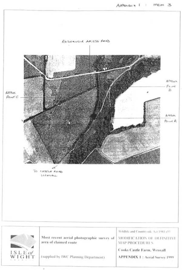
5.1 Aerial
Surveys held by the Council’s Corporate and Environment Services dated 1971,
1979, 1986, 1993 and 1999 have been examined. The scale of the photographs
varies between 1/5000 and 1/10,000.
5.2 The aerial
photographs are at a relatively small scale and features are indistinct unless
strongly marked. What can be seen is that in 1971 there was a path or track
available over CB between two areas of scrub, AB was open grassland as at
present with no strongly marked route.
V31 and V49 were well-worn tracks connecting with Yard Farm buildings
and Castle Road. A number of paths and
tracks are evident in 1979. CB is still strongly marked and a path diverting
from V31 corresponding to AB is also apparent. By 1986 there is more scrub in
the region of CB and it may or may not be available as a path, while AB appears
to be open through patches of scrub on either side. By 1993, AB is strongly
marked over open grassland and no path is marked over CB which appears to be scrubbed over.
6. ANALYSIS
OF EVIDENCE AND CONCLUSION
6.1 The
events of September 1999 first drew to the attention of the public using the
way that their rights were being called into question in terms of the
provisions of section 31 of the Highways Act 1980 and it was these events that
precipitated the claim process. The statutory period of use would be 20 years
counting back from this date, ie 1979 to 1999.
6.2 However,
the landowner’s evidence shows that the rights were first brought into question in February 1997 when she deposited
a plan and statement under the Highways Act 1980 s 31(6) which did not include
the route AB as an admitted highway. There is no evidence of public rights
being brought into question in any way prior to the date of the deposit.
Accepting the owner’s deposit under s31(6) was a calling into question, even
though this was not a public challenge, the earliest possible statutory period
would be1976 to 1996.
6.3 The
table shows that there has been continuous use of the route AB by the public on
foot and on horseback since 1968 and on foot as far back as 1940. As far as can be ascertained from witness
statements and interviews, this use meets the criteria for use as of right. All
witnesses asserted they were using the route as a public right of way.
6.4 It is
not possible to determine from aerial photographs whether routes are used by
the public, only what is physically apparent.
A route being used may not be physically apparent. Bearing this in mind,
the following inferences can be made. Before the relevant period a route CB,
the Definitive route of V34, was available because it was being used by Mr
Hayles and could have been used by the public. According to Mr Hayles’
statement, he used this route to reach the track he had made on or close to the
route of Footpath V32 to reach his fields.
By 1986, after the reservoir road was built, the tracks in the area are
less marked and there is more scrub, leading to the conclusion that there was
less farm traffic and less grazing. CB appears to have disappeared beneath
scrub, but there has always been a way open for AB and by 1993 the route AB is
clearly visible.
6.5 The
landowner has suggested that AB is only a deviation used by the public because
the route of CB was not kept clear of scrub.
However, at the beginning of the period of use, CB was available. No
witness mentioned inability to use CB as the reason for using AB, but confirmed
the reason for using AB was that it is a more convenient route than ACB in
terms of length and directness, and in terms of gradient and surface
vegetation. A landowner or user could
have drawn the need for maintenance to the attention of the Council at any time
and the Council would have responded. It is only in the last three years that
path clearance has been carried out as a proactive programme and it is normal
for a large amount of the Council’s maintenance duties to be carried out in
response to reports and requests. It is reasonable to conclude that the route
was used in preference to CB as a better route. Although there is a common law
right to deviate round an obstruction (which may result in the dedication of a
greater width), AB is physically separated from CB and must be considered as a
separate route which the landowner could have challenged.
6.6 Dedication
is deemed by operation of section 31 unless there is sufficient evidence during
the statutory period of the landowner’s intention not to dedicate. The only
evidence of no intention to dedicate is a statement by the previous landowner
Mr Hayles that riders were trespassing in using AB and that he directed them to
the bridleway by the hedge by pointing to it. However he also says in his
statement that he had no objection to riders on the land except through crops
and none of the witnesses reported experiencing a challenge. Although in the
earlier years of his ownership he was actively farming, he did not take any
steps during 26 years of ownership to express on a more effective and permanent
basis his intention not to dedicate, for example by notice, although he did do
so on another route nearby. In order to negate deemed dedication under section
31, the owner’s intention must be made explicit in such a way as to have a
reasonable chance of being received and understood by the public using the way
as a challenge to their rights. If
notices are torn down, the remedy is to notify the Council under that
section.
6.7 The
current landowner’s submission makes the following main points of evidence.
These are evaluated in corresponding sub-paragraphs of paragraph 6.8 below:
(1) The
Ramblers’ Association survey of 1974 did not identify any path in use that
diverged from the definitive line so the definitive line must have been in use;
(2) There
was no challenge from the public or the Highway Authority when AB was fenced
off for 18-24 months by Southern Water during the laying of the water main to
the new reservoir in 1980/1;
(3) There
was no possible route for horse riders during this period, although a temporary
pedestrian route was possible;
(4) Aerial
photographs 1979 and 1983 show the route used by the public changed between
these two dates;
(5) The
1979 photograph shows only one worn route so this must be the path, and not AB,
that witnesses are referring to when they say there was only one route;
(6) Points
A and B are in gorse so the route being claimed as used cannot be AB;
(7)
That in his amended statement the previous landowner
makes it clear that he did not condone haphazard public use of his land.
6.8 (1) In this letter the assumption is being
made that AB is the Definitive route of V34, and therefore it is this route
which is being compared to the proposed new route. No doubt the same assumption
was made by the surveyor in 1974 when
the definitive route was found to have no problems.
(2, 3) The
authority was aware of the effect of the construction work on the rights of way
and had been consulted by Southern Water. The water main does in fact run over
the route of V34 for much of its distance and a temporary closure order would
have been required while it was laid. Whether or not such an order was
obtained, such a closure would be a temporary suspension of the right of way to
permit construction work by statutory undertakers. It would not represent a
challenge or interruption by the landowner to the rights of the public as
required under the Highways Act s31 in order to negate a presumption of
dedication. At least one witness stated that it was possible to continue
walking the route by going round the water main fencing. Witnesses agree that
the reservoir construction caused disruption both at the site of the reservoir
itself and along the pipe line. Although some people gave up using the route as
too muddy, others went around the obstructions as best they could, whether to
the north west or the south east. It is clear they understood the rights to be
temporarily diverted for practical reasons and not as a challenge to the rights
of way which they were still exercising in some fashion. Given that the
reservoir was benefiting the village and some users directly, they would not
necessarily complain to the authority.
(4, 5) Many
routes and tracks are apparent on the 1979 photograph including the claimed
route. No 1983 photograph has been submitted; it is assumed the 1986 photograph
is being referred to. The claimed route AB is available. The photographic
evidence does not support either of these points.
(6) Although
passing close to scrub, the claimed route AB has been checked by using an
accurate Geo-Positioning System (GPS). Both points A and B are available.
(7)
Both versions of the previous landowner’s statement
make it clear that no overt actions of the kind required to negate deemed
dedication were taken on the claimed route AB except some personal challenges
from a distance to horse riders which were admitted to be ineffectual.
Witnesses who were horse riders stated they believed themselves to be using a
public right of way.
6.9 It is
concluded that a right of way is reasonably alleged to exist on grounds of deemed
dedication under section 31 of the Highways Act 1980 in consequence of an
uninterrupted period of public use as of right between 1976 and 1996 during
which there is insufficient evidence of an intention not to dedicate. A modification order should be made under
s53(3)(c) to add the route AB to the Definitive Map and Statement as a
bridleway with a width of 2 metres.
FINANCIAL
IMPLICATIONS
None
outside current budgets.
IMPLICATIONS
UNDER THE CRIME AND DISORDER ACT 1998
The
Council has a duty to make an order to modify the Definitive Map and Statement
or not according to its conclusions on the evidence. Should a right of way be
confirmed, any powers that may be available to the Council with respect to
Public Paths for the purposes of reducing Crime and Disorder could be
considered. However it is not considered that there will be any specific
implications in this case as there are already other established rights of way
in the same field parcel.
IMPLICATIONS
UNDER THE HUMAN RIGHTS ACT
In making
the recommendation to make the modification order consideration has been given
to the implications of the Human Rights Act.
In respect
of Article 6 (right to a fair trial) of the European Convention on Human Rights
it is considered that by advertisement of the proposed order and submission of
the report to the landowner for comments the Council has met the requirements
of this Article.
In respect
of Article 8 (respect for private and family life) and Article 1 of the First
Protocol (protection of property), the impacts that the modification might have
on the owners of this property and on owners of other property in the area and
users of the paths before and after modification have been carefully
considered. Whilst there may be some interference with the rights of the owner
it is considered that the recommendation to modify is proportional to the
legitimate aim of the Council and in the public interest.
OPTIONS
The
Council has a duty to make an order to modify the Definitive Map and Statement
or not according to its conclusions on the evidence.
RECOMMENDATIONS
That a
modification order be made to add the route shown AB on Map 2 at Appendix 1 as
a bridleway with a width of 2 metres.
BACKGROUND
PAPERS
Aerial
Photographic Surveys held by IWC Archaeological Unit 1971, 1979, 1986, 1993
Aerial
Photographic Survey held by IWC, Highways and Transportation, 1999
IWC
Archaeological Unit GPS Route Survey
HM Land
Registry Plan Title No. IW32509 Edition 22.12.99
DoE
Guidance Notes on Evidence 1989
Planning
Inspectorate Advice Note No 6 Oct 2000 re Sunningwell Judgement
24 Witness
Statements
17 File
notes of Interviews
IWC
Interview with Mr J Hayles
Highways
Act 1980 s31(6) Deposited Plan and Statement submitted by Ms Perrott 27.2.79
IWC to Ms
Perrott Acknowledgement of Receipt of Deposit 3.3.97
Letter IWC
to Councillor Yates 16.10.99
Letter IWC
to Wroxall Parish Council 16.10.99
Letter
Wroxall Parish Council to IWC 15.11.00
Letter Ms
M Perrott to IWC 23.8.99
Submission
and comments Ms M Perrott to IWC
RWA/V901
File note 20.11.01
Wiitness
Interview notes Ms M Perrott to IWC 20.11.01
APPENDICES
PLEASE
NOTE - Appendix 1 is attached to the report. Copies of Appendices 2 – 9 are available on
application to Committee Services. Tel 01983 823282.
Appendix 1
: Route Description
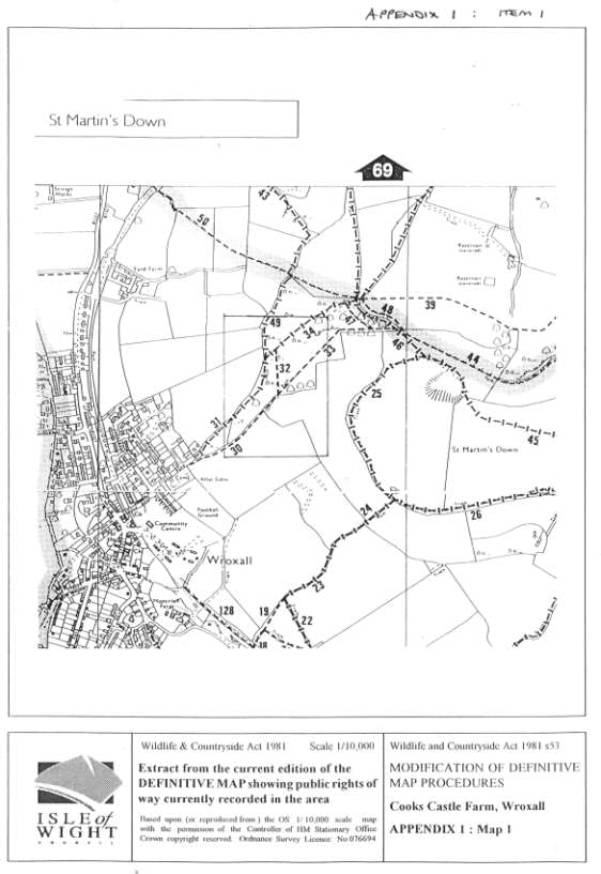
1.
Map 1: Definitive Map 2000 showing public rights of
way currently recorded in area
2.
Map 2: Plan of claimed route AB
3.
Most recent (1999) aerial survey of the area
Appendix 2 :
Legal Background to Modification Orders
1.
Guidance Notes on Evidence of Dedication issued by
Department of the Environment 1989
2.
Planning Inspectorate Advice Note No 6 Oct 2000 re
Sunningwell Judgement
Appendix 3
: User Evidence
1.
Table of User
Evidence
Appendix 4
: Landowner Evidence
1.
Highways Act 1980 s31 Deposited Plan : Ms M Perrott
27.2.97 (3 pages incl map)
2.
Letter Ms M Perrott to IWC 23.8.99 (1 page)
3.
Letter Ms M Perrott to IWC 20.9.01 : Submission of
Evidence (13 pages incl 2 maps)
4.
Letter Ms M Perrott to IWC 9.11.01 : Submission of
Documents relating to Submission of Evidence above (8 pages incl 2 photos):
(i) Amended Statement of previous landowner Mr J Hayles obtained
by Ms Perrott (3 pages incl map)
(ii)
Copy of letter Mr R Smith to Mrs J Deacon 27.10.96
and notes (3 pages)
(iii)
Copy of letter IWC to S Water 8.3.00
(iv)
Copy of heading of letter S Water to Ms M
Perrott 14.12.00 with attached copy of
letter signed Fred Caws (1 page)
(v)
Aerial Survey 1979 and enlarged extracts (4 pages)
5. Interview
Ms M Perrott and IWC Officers 20.11.01
(i) IWC File RWA/901 Officer’s Note of Interview 20.11.01
including two extracts from 1979 Aerial Survey Photograph illustrating Point 2
(ii) Notes of 5 interviews with witnesses submitted by Ms M
Perrott during interview
Appendix 5
: Documentary Evidence
1.
Aerial Survey 1971
2.
Aerial Survey 1979
3.
Aerial Survey 1986
4.
Aerial Survey 1993
Appendix 6
: Analysis of Evidence and Conclusion
No items
Appendix 7
: Comments of IWC
Local Member and Parish / Town Council
1.
Letter Wroxall Parish Council to IWC 15.11.00
Appendix 8 : Comments of current landowner on final
report and Council’s response
1.
Letter Ms M Perrott to IWC 28.10.02 (7 pages incl
copy letter and list of comments)
2.
Amended Summary of Evidence with reference list of
documents and copies of items CC32, 35, 37, 39, 41,43, 47,48 on this list (20 pages).
3.
Officer’s response to landowner’s comments.
Contact : Alex Russell (ext 3740), Rights of Way,
Engineering Services
M
J A FISHER
Strategic
Director, Corporate and Environment Services