PAPER C2
Purpose : For Decision
Committee : EXECUTIVE
Date : 9 APRIL 2002
Title : NORTH-EAST COAST OF THE ISLE OF WIGHT - COASTAL DEFENCE STRATEGY STUDY
THE LEADER OF THE COUNCIL
SUMMARY/PURPOSE
To seek the approval of the Executive for the preferred coastal defence policy options for the North-East coast of the Isle of Wight - Coastal Defence Strategy. Subject to approval by the Executive, the report will also be considered by the Hampshire and Isle of Wight Flood Defence Committee before submission to DEFRA for approval.
BACKGROUND
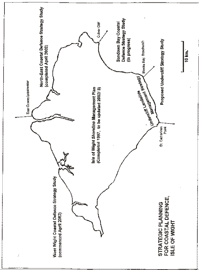
In 1997 the Isle of Wight Coast Shoreline Management Plan was completed. The Shoreline Management Plan (SMP) provided, for the first time, an overview of coastal defence issues relating to the 110 km of our coastline.
In line with DEFRA guidance more detailed coastal defence strategy studies (grant aided by DEFRA) are being undertaken in order to achieve the following aims :
1. To reduce the risk to people and the developed and natural environments from flooding and coastal erosion through the development of strategic coastal defence management options that;
C are based upon the principle of sustainable development.
C are compatible with natural coastal processes.
C take account of future changes to the environment as a consequence of climate change and sea level rise
C
take account of adjacent coastal strategies and other management plans
C are ‘owned’ and adopted by stakeholders and used to implement best practice.
2. In line with the above, to ensure that all proposals arising from the strategy avoid, as far as possible, tying future generations into inflexible and expensive options for coastal defence.
3. To develop both long term and short term plans :
C to develop strategic coastal defence management policy for the next fifty years (subject to five yearly review)
C to develop a fully integrated five year plan of works
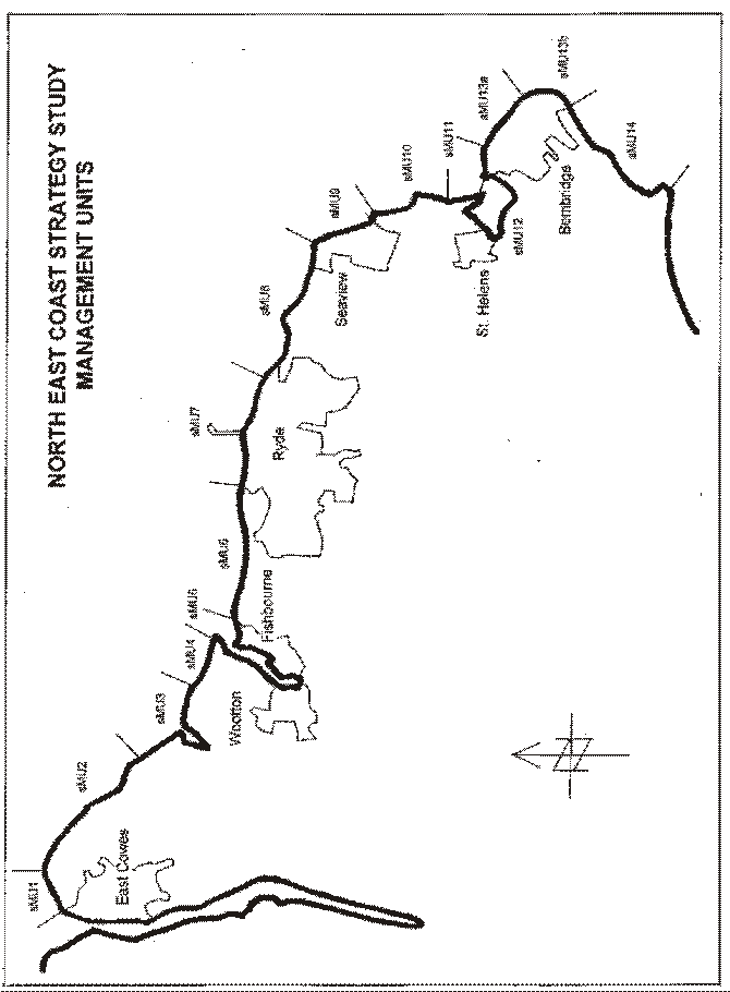
In line with these requirements the Council’s Centre for the Coastal Environment has developed a strategy plan for the north-east coast of the Isle of Wight. This is the first such plan to be developed for the Island and will be followed shortly by a strategy for Sandown Bay (currently in progress) and further strategies for the West Wight coast (recently approved by DEFRA) and in the future a coastal defence strategy for the Undercliff. The study area for the north-east coast strategy extends from the Shrape Breakwater at East Cowes on the eastern bank of River Medina to Culver Cliff, a distance of 29km, of which 20km are currently protected by coastal defence structures.
A number of lengths of defences are nearing the end of their effective life and may require attention within the next five years. To ascertain whether there is economic justification for renewing the existing defences, the quantitative values of the assets at risk within defended areas were evaluated and compared with the likely costs of replacing / renewing the defences. The implications of defending lengths of the coastline for both the natural environment and the built environment were evaluated also, together with the impacts upon natural coastal processes and other environmental issues. The strategy aims to provide sustainable shoreline management solutions, which have limited or no impacts upon the existing environment, in line with the current guidance from DEFRA and in compliance with national and European legislation.
As part of the study the relevance and influence of the geology, geomorphology and coastal processes over the study area were established together with details of the existing defences, taking into account the influences and needs of both the natural environment and the human and built environments.
Project Methodology
The strategy study comprised four main stages : data gathering, definition of the scope of the study, definition of the management unit boundaries and the appraisal process. Consultation with steering group members, other interested parties and the general public was undertaken throughout the strategy. The results of these study stages and the consultation were combined to produce the final study report.
In terms of consultation the strategy study began with a data gathering exercise, which included the first stage of the consultation process. A second stage of consultation was concluded following the completion of the consultation draft report and public exhibitions held at Wootton, Ryde and Bembridge. The aims of the consultation programme were to obtain the views, concerns and any relevant data regarding the existing and future management of the study coastline. Consultation responses highlighted views, issues and concerns which were included in the appraisal process to help identify preferred strategic defence options. Concurrent with the general consultation, more specific enquiries were raised with various special interest groups such as landowners, service industries, environmental bodies and other organisations. Consultation responses were collated and incorporated within the strategy documents.
In terms of data gathering, erosion rates along the frontage and the location of flood risk areas were both determined during the data gathering programme. This helped establish where the land potentially is at risk over the next fifty years, and assisted with the development of economic and environmental baselines. Data relating to the existing defences, the physical and the environmental surroundings were collated and assimilated into this strategy.
Strategic Management Units
Once the issues along the coastal frontage had been established, the management unit (MU) boundaries were considered. Management units are lengths of coastline that require a specific coastal defence option in order to meet the coastal defence requirements. Management units were identified and refined following the Shoreline Management Plan process in 1997 based upon geomorphological processes, geological and geographical evolution, land use and the natural environment.
DEFRA require four generic options to be considered for each management unit frontage, namely ‘do nothing except monitor’ (no ‘intervention’, ‘managed retreat’, ‘hold the line’ and ‘advance the line’. An initial appraisal process identified and discarded from further consideration those options that were neither realistic nor acceptable or that were incompatible with natural processes and / or management in adjacent management units, or that did not meet the strategic objectives of the study.
In the second stage of the appraisal process the remaining options for each management unit were examined in more detail. The resulting impacts upon technical, economic and environmental issues were considered. The consequences of each remaining option were assessed with respect to the adjacent units both updrift and downdrift within the coastal sub-cell.
The outcome of this detailed process resulted in the recommendation of a ‘preferred policy option’ for each frontage. As well as taking account of an economic assessment in relation to coastal defence costs the preferred option had also duly considered a strategic environmental assessment which had been prepared as part of the strategy study. The preferred option is the best possible solution, based upon consideration of all the issues identified for the frontage concerned.
In total fourteen management units (some sub-divided) were defined for the study coastline. These are as follows:
Strategic management units |
Study Units |
Preferred policy option |
sMU1 |
East Cowes Breakwater to Old Castle Point |
Hold the line by maintenance |
sMU2 |
Old Castle Point to Barton Hard |
Do nothing but monitor |
sMU3 |
Barton Hard to Rock Point |
Do nothing but monitor |
sMU4 |
Rock Point to Wootton Rocks |
Do nothing but monitor |
sMU5 |
Wootton Rocks to Fishbourne Copse |
Hold the line |
sMU6 |
Fishbourne Copse to Pelhamfield |
Do nothing but monitor |
sMU7 |
Pelhamfield to St Cecilia s Abbey |
Hold the line |
sMU8 |
St Cecilia s Abbey to Nettlestone Point |
Hold the line |
sMU9 |
Nettlestone Point to Horestone Point |
Hold the line |
sMU10 |
Horestone Point to St Helens Point |
Do nothing but monitor |
sMU11 |
St Helens Point to Ducie Avenue |
Hold the line |
sMU12 |
Bembridge Harbour |
Hold the line |
sMU13a |
Ducie Avenue to Lifeboat Station |
Managed retreat by slowing the rate of erosion |
sMU13b |
Lifeboat Station to Foreland Fields |
Hold the line |
sMU14 |
Forelands Field to Culver Cliff |
Do nothing but monitor |
With respect to the above options the following points should be noted.
sMU5 - Wootton Rocks to Fishbourne Copse : The project steering committee recommended that An Estuary Management Plan should be developed for sustainable management of Wootton Creek. This will include a more detailed assessment of coastal defence issues within and at the mouth of the creek and will inform the next five year review of this Strategy Study.
sMU6 - Fishbourne Copse to Pelhamfield : With respect to this frontage English Nature have been advised about the concerns of Quarr Abbey and other frontagers with respect to the loss of coastline and its impact on historic landscape features. The Coastal Manager believes that hydrogeological problems and resulting slope instability are significant factors compared with coastal erosion. English Nature have been put in direct contact with frontagers in relation to some of the environmental issues raised.
sMU8 - Pelhamfield to Nettlestone Point : This frontage includes the Seaview Duver where a coastal defence scheme has been developed in parallel with the Strategy Study. The scheme has received planning consent and an application for coast protection grant aid for the project has been submitted to DEFRA. Subject to scheme approval it is hoped that work can start later in the summer; a scheme at Seagrove Bay, Seaview, was completed in summer 2000.
sMU12 - Bembridge Harbour : For both economic and environmental reasons the original preferred policy option for the St Helens Duver frontage within the harbour was managed retreat. However, following a meeting with the Parish Council and local residents, it has been agreed that a temporary ‘hold the line’ policy be implemented. This has involved the Council undertaking some repairs to the St Helens wall to prevent the risk of a possible breach. A meeting has been held with the DEFRA Regional Engineer together with Bembridge Harbour Company and the Parish Council. An application is being submitted to DEFRA for a more detailed grant-aided study of the implications of a range of coastal policy options on St Helens Duver frontage and on Embankment Road, Bembridge. This proposed study entitled ‘Bembridge Harbour and East Yar Valley Strategy Study’ is likely to be eligible for coast protection grant aid and will be undertaken by the Council in partnership with the Environment Agency. The results of this study would inform future decision-making on Bembridge Harbour and St Helens Duver frontages in particular.
sMU13a - Ducie Avenue to Bembridge Lifeboat Station : Arising from this Strategy Study it is recommended that a Beach Management Plan is developed for the frontage and that an application for funding be sought from DEFRA for a beach recycling scheme. The scheme will involve some upgrading of the existing groynes and beach replenishment. If approved by DEFRA a grant-aided beach management scheme would allow for recycling of beach material from the down-drift end at Bembridge Point every five years.
sMU14 - Forelands Fields to Culver Cliff : Private coastal defences constructed in the past within Whitecliff Bay are both unsightly and at least some of the structures are not proving effective and may be causing increased erosion downdrift. It is recommended that discussions be opened with the owners of the clifftop developments in order to discuss opportunities for environmental enhancement and removal of some defences.
The cost of the Strategy Study and any approved protection schemes arising from it will be grant aided by DEFRA. The question of grant aid for the further study of Wootton Creek will be explored with our DEFRA Regional Engineer. If grant aid is unavailable the study will still be undertaken but using the resources of the Centre for the Coastal Environment. The likely impact on the budget will be £20,000 in staff time if grant aid is not forthcoming.
OPTIONS
The North-East Coastal Defence Strategy Study is the result of two years of detailed technical investigations that have involved extensive public participation and exhibitions. The study has been undertaken within DEFRA guidelines and provides a framework for future coastal defence schemes and studies. Although the study is intended to provide a long term sustainable strategy for the frontage, there will be the opportunity to examine and refine the coastal defence policy options at five yearly intervals; the five yearly reviews will also be grant aided by DEFRA. The Executive is asked to consider the strategic management unit preferred policy options for which approval is sought (taking account of the notes provided above).
RECOMMENDATION
1. The preferred coastal defence policy options for strategic management units 1-14 on the Isle of Wight north-east coast be approved.
2. The action points highlighted on pages 4 / 5 - be supported.
3. The submission of applications for coast protection grant aid for a study of Bembridge Harbour and the East Yar Valley and for a Beach Management Plan for the Bembridge frontage be approved. |
BACKGROUND PAPERS
Isle of Wight Centre for the Coastal Environment / Posford Duvivier / University of Portsmouth - North-east coast of the Isle of Wight - Coastal Defence Strategy Study 1999-2001
Isle of Wight Centre for the Coastal Environment / Posford Duvivier - North-east coast Strategy Study Strategic Environmental Assessment 2001.
Contact Point : R G McInnes, F 3770
M J A FISHER Strategic Director Corporate and Environment Services |
S SMART The Leader of the Council |