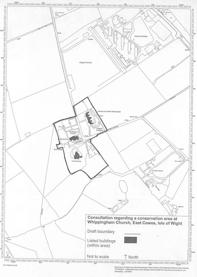
PAPER D


                                                                                                              Purpose : For Decision

                        REPORT TO THE EXECUTIVE


Date :              3 NOVEMBER 2004


Title :               PROPOSED CONSERVATION AREA AT WHIPPINGHAM CHURCH


REPORT OF THE PORTFOLIO HOLDER FOR SUSTAINABLE DEVELOPMENT, ENVIRONMENT AND PLANNING POLICY


IMPLEMENTATION DATE : 15 November 2004


SUMMARY/PURPOSE


1.                  To designate the area as a conservation area and approve the character statement, in accordance with policy B5 of the Isle of Wight Unitary Development Plan.


BACKGROUND


2.                  The Planning (Listed Buildings and Conservation Areas) Act 1990 at section 69 states that –


“(1) Every local planning authority –

(a)              shall from time to time determine which parts of its area are areas of special architectural or historic interest the character or appearance of which it is desirable to preserve or enhance, and

(b)              shall designate those areas as conservation areas.


(2) It shall be the duty of a local planning authority from time to time to review the past exercise of functions under this section and to determine whether any parts or any further parts of their area should be designated as conservation areas; and, if they so determine, they shall designate those parts accordingly.”


The section also indicates the power of the Secretary of State to designate, and notes that designations become a local land charge.


Members may recollect that a report was received by the then Planning Committee on 3rd April 2001 “To consider the designation of the Conservation Area located in and around the Whippingham Church area and to proceed to designation immediately.”


The committee resolution was “THAT further consultation be undertaken on the designation of the Conservation Area located in and around the Whippingham Church and any suggested amendments be brought back to Committee.”


The matter was further reported to the Development Control Committee on 23rd April 2002 with the recommendation “To discontinue the procedure and agree not to designate a Conservation Area around Whippingham Church, but to review the situation in twelve months time.”


The committee resolved “THAT the procedure to designate a Conservation Area around Whippingham Church be discontinued.”


Subsequent to this decision, a complaint alleging mishandling of the matter was made to both the Local Government Ombudsman and to the Audit Commission. The basis for this complaint was that the recommendation to Members was allegedly changed as a result of public pressure, and that Members failed to act in accordance with their duty under section 69 (1) of the Act.


Although no maladministration was found against the Council, the Head of Planning Services agreed to further review the matter and the case for a conservation area at Whippingham as part of an agreed work programme to review all existing conservation areas and to consider the designation of new ones across the Island.


Having made an analysis of the character and appearance of the area, the suggested boundary (Plan 1) and draft character statement (Appendix 1) were put out to public consultation. The results of that consultation are at appendix  3 of this report.


STRATEGIC CONTEXT


3.                  The legislative background providing for the designation of conservation areas is noted above. National advice is set out in section 4 of Planning Policy Guidance 15: Planning and the Historic Environment, and English Heritage publish criteria relating to the assessment of subject areas.


The Island’s UDP sets criteria for the designation of conservation areas under policy B5 and these criteria relate to those noted nationally. The assessment of the Whippingham area has been carried out bearing in mind both local and national criteria.


The Planning Services Service Plan for 2004/2005 has as one of its aims and objectives “providing an up-to-date planning framework for the protection of the natural, built and historic environments”, and as part of its strategic improvements notes Task PP3 as the review of boundaries of existing conservation areas, Task PP4 as “assess the potential for new conservation areas” and Task PP5 as the “preparation of character statements for conservation areas”.


4.                  This recommendation is in accordance both the aims and objectives and of the strategic improvements set out in the Service Plan, the UDP, and is in accordance with legislative requirements and national guidance.


CONSULTATION


5.                  As noted above, the proposed character statement (Appendix 1) and draft boundary (Plan 1) have been the subject of public consultation in accordance with the agreed procedure. The details were posted on the Council’s website, a site notice was placed within the area, and copies of the papers were deposited at reception at the Council’s Seaclose offices. Letters were sent to each property within the proposed boundary, along with the following :-

Whippingham Community Partnership; local Members; East Cowes Town Council; the Isle of Wight Society; the Victorian Society; English Heritage; Whippingham Visitor Centre; Osborne Works; Sunnyside and Riverview at Padmore; Padmore House; Padmore Lodge; Padmore Bungalow. Advice was also sought from the County Archaeologist. The consultation lasted a little over 6 weeks.


The Council has received 3 responses, 2 in support of the designation, and 1 of complaint. The details of those responses are set out in appendix 3 to this report, along with the Council’s response to each.


FINANCIAL/BUDGET IMPLICATIONS


6.                  There are no direct financial implications attached to the designation of conservation areas. The costs of consultation, advertising and notification have been absorbed within existing budgets. The designation may result in additional planning applications which are fee earning, but in this case the number of properties is small and several of them are listed so the consequent impact is considered to be minimal. There may also be additional notifications in respect of works to trees within the area, but the Head of Planning Services considers that this is acceptable within current budgets.


7.                  Any future proposals for the enhancement of a conservation area (under Section 71 of The Act) will be subject to the availability of funds at the time they are proposed.


LEGAL IMPLICATIONS


8.                  The Planning (Listed Buildings and Conservation Areas) Act 1990 at Section 69 places a duty on each local planning authority to designate areas as conservation areas if they are considered to be of suitable quality or interest. (The law is set out fully in section 2 of this report)


Government guidance in PPG15 confirms this duty and indicates that an authority’s reasons for designation as reflected in its assessment of the areas special interest, its appearance and its character are factors which the (First) Secretary of State will take into account in considering appeals against refusals of planning permission.


In coming to the recommendation to designate a conservation area, consideration has been given to the rights set out in Article 8 (Right to Privacy) and Article 1 of the First Protocol (Right to peaceful enjoyment of possessions) of the European Convention on Human Rights. It is recognised that the designation of a conservation area would limit certain development rights and may be an interference with the occupier’s human rights, but this has to be balanced against the responsibility of the Local Planning Authority to carry out its duty to preserve and enhance the historic environment. The action is felt to be proportionate to the legitimate aims of the Council’s Unitary Development Plan and accords with current policies and guidance.


If Members are minded to designate in accordance with the recommendation in this report, that designation takes effect immediately, though there is a requirement to place an official notice in the London Gazette and 1 local newspaper. In practice, and in addition to this, notifications are sent to all of those who were notified initially, along with any further persons who made representations, along with various official bodies and departments of the Council.


9.                  If Members are minded not to agree with a recommendation to designate, they must ensure that their reasons are clear, relevant, and carefully recorded.


This matter has previously been referred to the Local Government Ombudsman, and whilst no maladministration was found, there was some doubt as to the process, hence the decision to revisit the case. The officers reasoning in respect of the location of the proposed boundary (Appendix 2) is attached to this report in the interests of clarity and open-ness.


OPTIONS


10.             There are 4 options available to Members in this instance –

(a)               To designate the area shown on Plan 1 as a conservation area

(b)               To receive as part of an overall review of the Island conservation area designations, a future report considering the suitability of some or all of the Osbourne Estate for designation as a conservation area.

(c)               To choose a different boundary and provide the necessary character assessment and reasoning to support it

(d)               To resolve not to designate and provide their reasons in the light of Section 69


EVALUATION/RISK MANAGEMENT


11.             The recommendation here is to designate the area shown on Plan 1 as a conservation area (option a) as the area is considered to meet the relevant criteria set out in both the UDP and in national guidance. It is also in line with the aims and objectives of the relevant Service Plan.


It may be that there will be a further referral to the Local Government Ombudsman as the area covered is not that which is sought by the objector. If that does occur, then Members should be confident that the process leading to this particular report has been as transparent as possible.


If Members are minded to vary the boundary (option b) they need to be clear as to their reasons in relation to the relevant criteria and their duty under Section 69. Variation of the boundary may also result in a further referral to the Ombudsman, so again clarity of reasoning is vital.


RECOMMENDATION


14             That the Executive resolves


i)                    To designate the area shown on plan 1, as a conservation area and approves the character statement, in accordance with policy B5 of the Isle of Wight UDP in accordance with option a above.

ii)                  To receive as part of an overall review of the Island conservation area designations, a future report considering the suitability of some or all of the Osbourne Estate for designation as a conservation area.

BACKGROUND PAPERS


15             The Planning (Listed Buildings and Conservation Areas) Act 1990

PPG15

Isle of Wight Unitary Development Plan

Planning Services Service Plan 2004/2005

Planning Committee paper B1 – 3 April 2001

Development Control Committee paper D – 23 April 2002


ADDITIONAL INFORMATION


12.             Plan 1 – proposed boundary for conservation area

Appendix 1 – Draft character statement

Appendix 2 – Background note re the draft CA boundary

Appendix 3 - Consultation


Contact Point : Janet Dore                                      Telephone 01983 823856

                                                                                    Email  [email protected]


ANDREW ASHCROFT

Head of Planning Services

TERRY BUTCHERS

Portfolio Holder for Sustainable Development, Environment and Planning Policy


Appendix 1

Whippingham Church

proposed conservation area


draft character statement


The legal background

Section 69 of the Planning (Listed Buildings and Conservation Areas) Act 1990 imposes a duty on local planning authorities to designate as conservation areas any ‘areas of special architectural or historic interest the character or appearance of which it is desirable to preserve or enhance’. Section 69 also requires authorities to review their areas from time to time to see if further designation or alteration to existing designations is necessary.


Planning Policy Guidance: Planning and the Historic Environment (PPG15) deals in some detail with the assessment and designation of conservation areas in section 4, and the adopted planning policy documents for the Island contain sections relating to development within such areas. 


Character

This small group appears very little influenced by modern times, and could quite easily still exist in the Victorian era. It is an enclave of peace and quiet, separated from the 21st century by a few fields, and the buffer provided by those fields is vital to its existence. The buildings themselves are individuals which adhere to a hierarchy relative to their size, but follow no other rules.

NB this expression of ‘character’ is derived from the study below.


History of development

A church was noted in the Doomsday book but was rebuilt by Nash in c1804. When Queen Victoria came to the Island the church was partly dismantled and rebuilt to designs influenced by Prince Albert. The almshouses were added to the group later during Queen Victoria’s reign.


Setting

The cluster is set between the A3021 Newport – East Cowes road and the Medina River. There are views down to the river, but there is no evidence of the main road either visually or aurally. The surroundings are pure countryside giving the group a quiet and isolated feel, even though it is so close to developed areas and a busy road.


Materials

The local stone was used for earlier structures including boundary walls, and the church which, although having early origins, has been much altered and rebuilt. The ‘Victorian’ buildings make use of bricks made from local clay which are of a warm red colour. Roofs are either of slate or clay tile.


Height, mass & form

The notable comment regarding height, mass and form in this area is that there is absolutely no consistency. The characteristics of each building relate to its place in the hierarchy of the group with the church as the dominant feature.


Typical details

Again there is nothing which can be described as typical in this area save for the ‘Victoriana’ and decorative ethic associated with that period on those particular buildings. Overall the buildings are reasonably true to the period from which they date, though some modern insertions (plastic windows) have diluted the authenticity a little.   


Paving

Informality, simplicity and the advance of grass sum up the paved landscape here. The simple blacktop road is the major area of paving, with its edges crumbling into grass verges. The almshouses have some brick paths, but for the most part, paths are an original hard surface which has been overtaken by grass.


Trees and open space

The area has plenty of mature trees both within and around it, many of them set in ancient boundary hedges and banks. There are, of course, yews in the churchyard. Open space flows through the area linking it to the open country which surrounds it. The buildings are set in spacious plots, well back from the road, so there is no sense of being in a village, simply of passing through a group of buildings in the countryside.


Sound and smell

No smells have been associated with this area. In terms of sounds, the significant point is the silence. Birdsong and the occasional vehicle do interrupt the peace, but for such an accessible area, it is notably peaceful and quiet.


Appendix 2


Background note re the draft CA boundary for Whippingham Church

The controls that come about when a conservation area is designated relate to planning powers. They mean that express consent is required for the demolition of buildings, and that works to trees must be notified in advance. Where new development or change to existing buildings is proposed within or adjacent to the area (setting), it means that care must be taken to ensure that new work will either preserve or enhance the special character of the area. Where proposals include the demolition of a building, then that demolition has to be justified both in terms of why the building can’t be kept, and how good the replacement building will be. Prior notification of works to trees allows the Council to put a TPO in place if the tree(s) in question is of sufficient quality and importance to the area.


Designation does not mean that development cannot take place, either within the area or within its setting, but that special consideration is required to ensure that any demolition is justified, and that schemes which are acceptable on all other planning grounds are of a suitable design and high enough standard to be acceptable. This additional level of consideration allows Members to insist upon the best possible standards of design for the Islands new developments, and allows them to refuse the poor and mediocre with confidence.


The legislation also makes provision for schemes to enhance the area, so the inclusion of areas of potential allows for schemes to be put forward which will improve the area in keeping with its own individual character to the same high standard.


In the case of Whippingham Church the reasons for the proposed boundary being in the location shown on the map attached to the draft character assessment are as follows :-

·         In terms of a sense of place, the small group of buildings is quite compact and discreet.

·         The open surroundings form a strong contrast to the built form and this element of the setting has been identified as important to the character of the area.

·         Other buildings in the area are separated from the group and from each other by open fields and,

·         they do not address the same focus as the identified group.

·         There may be a case for a much larger and different kind of conservation area relating to the buildings of the Osborne Estate, but this needs to be considered as part of the Council’s overall review of its conservation area designations.

·         The ombudsman requested that this area be reconsidered following previous acrimonious exchanges on proposals to designate, and the boundary concerned at that time. In this case the area was studied ‘cold’ with no previous knowledge of what had gone before. The present proposal is put forward as a reasoned professional recommendation, which has not been influenced by that which has gone before.


Appendix 3


Representation received as a result of public consultation


NB The matter was discussed with the County Archaeologist who did not wish to add anything to the assessment of the area.


From

Comments

Response

The Victorian Society

Feel that the area proposed meets the criteria for designation and welcomes the Council’s action.


They point out an error in dating the almshouses in the draft statement.


They suggest that more detail on each building would be helpful.

The recommendation is in accordance with this comment.


This has been addressed in the version attached to this report.


Officers have agreed that a schedule will be prepared noting each building, and that this schedule will be available as an addition to the overall character statement. As that schedule will be simply observed detail it is not considered necessary for Members to approve it. If designation is approved, the additional work will follow shortly.

Mrs S Weaver, 17 Crown Court, Cowes

Writes to add her support to the conservation of the historic buildings of the island.


She regrets that the area does not include fields and individual buildings along the riverside.

Noted.


PPG15 notes at paragraph 4.2 that “It is the quality and interest of areas, rather than that of individual buildings, which should be prime consideration in identifying conservation areas.”

Angela Hewitt, Padmore Lodge, Beatrice Avenue, Whippingham

Notes that the boundary now put forward differs from that previously suggested and considers this a “flagrant act of maladministration”.


She lists 8 sites which she notes have been omitted of which she notes that 3 objected to the previous proposal.


She alleges misuse of section 69 of the Act on the ground that it only refers to existing conservation areas.


She states that there is no reason to reduce the area proposed, and many reasons to increase it. She proposes the inclusion of additional land up to and along the A3021.


She notes that property belonging to previous objectors has been omitted and that objection is not a good reason in law. She further suggests that the omission of other properties, including her own, is as ‘payback’ for making a complaint to the Ombudsman.


She considers that the original proposal should be considered and that in proposing a different area, the Ombudsman’s recommendations are being ignored.


She alleges deception in that the map attached to the consultation “does not even cover the areas you have left out”


and that “it does nothing to protect the setting of the village”.


She mentions development ‘threats’ and their impact on the “visual aspect”.


She states that in omitting the school, post office and Padmore House, the historic importance of the area has been ignored.


She notes that she contacted HRH Prince Charles on the matter previously and that he involved the Director of English Heritage.


She cites an interpretation of PPG15 in relation to available resources as a negative angle to designation.


She advises that she is copying her letter to the Ombudsman and is considering a further complaint.

See the bullet points in appendix 2 in relation to the reasons for the boundary location. In terms of alleged maladministration, advice has been sought from the relevant Council departments before submission of this report to Members.


See the final bullet point of appendic 2 in relation to the assessment being made without previous knowledge.


See the quotation from the Act at section 2 of this report. Section 69 (1) refers here, section 69 (2) deals with the review of existing conservation areas.


See the bullet points in appendix 2 in relation to the reasons for the boundary location, and in particular the penultimate point which raises the possible consideration of an ‘Osborne Estate’ conservation area as part of the overall review of designations.


See the bullet points in appendix 2 in relation to the reasons for the boundary location, and the assessment being made without previous knowledge.


No maladministration was found previously, though the Councils Head of Planning Services did agree to review the matter.


The map used for the consultation, and for this report, clearly shows the area on which comments were being sought in its context. It was a clearly printed extract from the OS.


The effect on the setting of a conservation area is a material consideration.


The effect on the setting of a conservation area is a material consideration.


PPG15 notes at paragraph 4.2 that “It is the quality and interest of areas, rather than that of individual buildings, which should be prime consideration in identifying conservation areas.” See also  the bullet points in appendix 2 in relation to the reasons for the boundary location, and in particular the penultimate point which raises the possible consideration of an ‘Osborne Estate’ conservation area as part of the overall review of designations.


English Heritage was consulted as noted in section 5 of this report. At the time of writing no comments have been received from them.


Resources have been considered and the recommendation here is in favour of designation.


Noted.