
PAPER B
Purpose: for Decision
REPORT TO THE EXECUTIVE
Date: 25 AUGUST 2004
Title : PROPOSED CONSERVATION AREA FOR WHITECROFT HOSPITAL SITE
REPORT
OF THE PORTFOLIO HLDER FOR SUSTAINABLE DEVLOPMENT, ENVIRONMENT AND PLANNING
POLICY
Implementation
date: 7 September 2004
PURPOSE
1.
To approve
the designation of the former Whitecroft Hospital, together with associated
areas as a conservation area.
BACKGROUND
2.
The site of
the former hospital and associated buildings were occupied as a psychiatric
hospital prior to its closure in 1992. The buildings are now mostly disused
although some administrative office within the former nurses home are still in
use. A number of dwellings within the site which were formally occupied by
hospital staff are now in independent residential use.
3.
The main
site including the former hospital buildings and the landscape grounds have
been sold, have been marketed and are available for re-development or reuse.
There is a development brief relating to this site.
4.
The
buildings and landscape setting have been identified as having considerable
character and local importance. In addition, there are important associations
with the social history and historic development of health care on the Isle of
Wight. The location, setting and design of the buildings are such that the site
has a clearly identified character and the buildings are considered to be of
significant local architectural and historic interest. In addition, the main
clocktower and associated structures are of national importance being Listed
(Grade II).
5.
An appraisal
of the area has been carried out which identifies the historic development and
characteristics of the site and this is attached as a background paper to the
report.
6.
Section 69
of the Planning (Listed Buildings and Conservation Areas) Act 1990 indicates
that: “Planning Authorities have a duty from time to time to determine which
parts of their areas are of special architectural or historic interest which it
is desirable to preserve or
enhance.” In addition, Government guidance contained in Planning Policy
Guidance Note 15 (PPG15) “Planning and the Historic Environment” indicates that
Planning Authorities should formulate and publish proposals for the
preservation and enhancement of conservation areas.
7.
The special
characteristics of the buildings and associated landscape setting, together
with the fact that the majority of the buildings are no longer in use and may
be subject to development proposals indicate that this is the opportunity to
designate a conservation area which will inform any redevelopment proposals. It
must be stressed that the purpose of designating such an area would not be to
prevent future developments but to insure that this is carried out in such a
way as to protect the character and setting of the area and to identify
opportunities for enhancing those characteristics where possible.
STRATEGIC CONTEXT
8.
The aims of
the Planning Service as identified in the service plan include:
·
To protect
and enhance the natural, built and historic environment of the Isle of Wight.
·
To provide
an up to date planning framework to encourage appropriate development to come
forward in a sustainable manner
9.
The service
plan identifies one of the planning policy improvements as the assessment of
the potential conservation areas (Task PP4) to ensure that historic parts of
the island are assessed against their potential to be designated as
conservation areas. The preparation of character statements for conservation
areas has also been identified as an improvement target.
10.
There is a
development brief for the site which was updated and approved by the
Development Control Committee on 25 June 2002. This brief refers to UDP Policy
C17 regarding reuse of buildings of architectural or historic merit and also
indicates that the clock tower and entrance block together with the Rhodes
Tennyson block are suitable and desirable for reuse.
11.
Government
advice regarding the designation of conservation areas is contained in PPG15
and states that designation introduces a general control over the demolition of
unlisted buildings and provides the basis for policies designed to preserve or
enhance all aspects of character or appearance that define an area’s special
interest. The document also indicates that it is also the quality and interest
of areas rather than of individual buildings which should be the prime
consideration in identifying conservation areas. (Section 4).
12.
The IW
Unitary Development Plan also indicates that the Local Authority has a duty to
consider the designation of areas of special architectural or historic
character and Policies S10 and B6 particularly relate to the protection of such
areas. Policy B5 sets out the criteria for designation of conservation areas.
CONSULTATION
13.
Members are
advised that following an initial approach from some local residents, an
appraisal of the area has been carried out and local residents and other
interested parties, including the site owners, amenities societies and the
Parish Council have been notified. A meeting has also taken place with local
residents to discuss the proposals.
14.
In addition,
a press notice resulted in an article in the County Press and an exhibition has
been provided in the reception area at Seaclose. The proposal has also been
placed on the Council’s web site.
15.
As a result
of the above a number of representations have been received which are
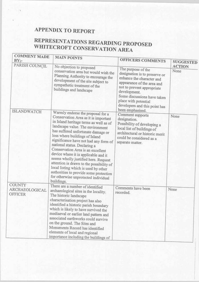
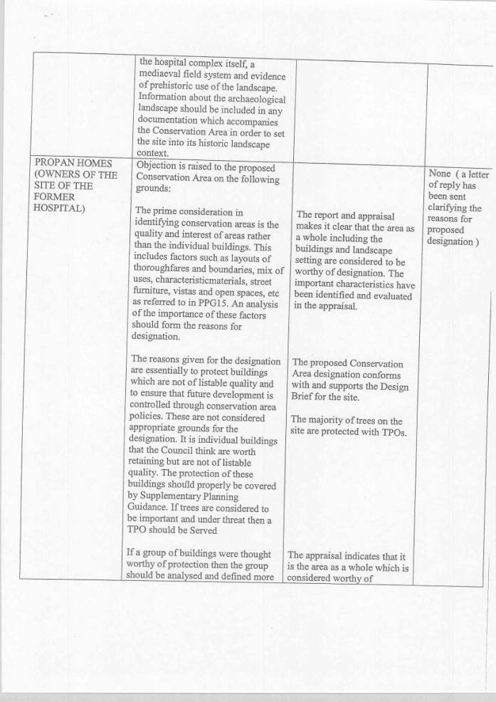
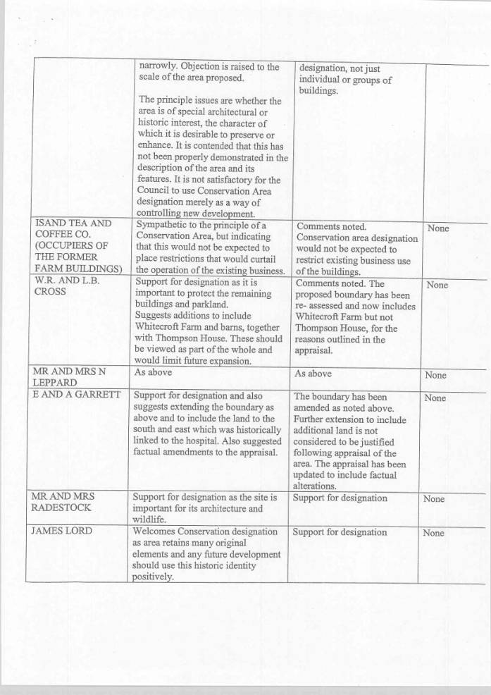
summarized in the appendix to this report.
16.
The comments
received have generally been in favour of designation as a Conservation Area
and have not resulted in any changes apart from alteration to the proposed
boundary to include Whitecroft Farm for the reason outlined in the appraisal.
17.
The comments
of the site owners are also noted, but the proposed designation to preserve or
enhance the character of the buildings and landscape setting is considered to
be in line with Local and Government Guidelines.
FINANCIAL/BUDGET IMPLICATIONS
18.
There would
be no direct financial implications as a result of designating this
conservation area. Members will be aware designation of a conservation area
does limit certain permitted development .rights in respect of proposed
developments and may therefore result in a small number of further applications
being submitted in the future. This would however, be limited in nature, particularly
bearing in mind the fact that there are very few residential properties
existing within the proposed boundary. There would be a limited cost for
placing the statutory press notices.
19.
Designation
of a conservation area would require any future applications to be considered
in the context of preserving or enhancing the character of the area.
20.
Members will
also be aware that the Council has a duty to consider proposals for enhancing
the character of the area and to carry out, from time to time, appraisals of
the character of the area. This would involve some staff resources and possible
costs in publishing proposals for enhancement. It is anticipated that these
cost could be absorbed in existing budgets and would be spread over a period of
time.
LEGAL IMPLICATIONS
21.
Section 69
of the Planning (Listed Buildings and Conservation Areas) Act 1990 places a
duty on Local Authorities to consider the designation of areas which have
special architectural or historic character which it is desirable to preserve
or enhance. Section 71 of the Act places a duty on Planning Authorities to
formulate and publish proposals for the preservation and enhancement of
conservation areas.
22.
Government
guidance contained in Planning Policy Guidance Note 15 confirms this duty and
indicates that an Authority’s justification for designation as reflected in its
assessment of an area’s special interest and its character and appearance is a
factor which the Secretary of State will take into account in considering
appeals against refusals of planning applications.
23.
The
designation of a conservation area does introduce controls over the demolition
of unlisted buildings and also reduces the permitted development rights for
certain development mostly relating to domestic properties.
24.
Any works to
trees within a designated conservation area would require the submission of a 6
week notice to allow the Local Planning Authority the opportunity to serve a
Tree Preservation Order. Members are advised that the majority of the trees
within this site are already covered by Tree Preservation Orders.
25.
There is no
statutory requirement to consult prior to the designation or cancellation of a
designation but it will be highly desirable that there should be consultation
with local residents, businesses and other local interests.
26.
Section 70
of the Planning (Listed Building and Conservation Areas) Act 1990 indicates
that notice of designation, variation or cancellation with particulars of its
effect shall be published in the London Gazette and in at least one newspaper
circulating in the area of the Local Planning Authority.
27.
In coming to
the recommendation to designate a conservation area, consideration has been
given to the rights set out in Article 8 (Right to Privacy) and Article 1 of
the First Protocol (Right to Peaceful enjoyment of possessions) of the European
Convention on Human Rights. It is recognized that the designation of a
conservation area would limit certain development rights and may be an
interference with the occupier’s human rights, but this has to be balanced
against the responsibility of the Local Planning Authority to carry out its
duty to preserve and enhance the historic environment. The action is felt to be
proportionate to the legitimate aims of the Council’s Unitary Development Plan
and accords with current policies and guidance.
OPTIONS
·
To agree the
designation with immediate effect and to serve the necessary public notices.
·
Not to agree
the designation and to identify the reasons why the area is not considered to
have special architectural or historic character.
·
To agree the
designation with revised boundaries.
EVALUATION/RISK MANAGEMENT
28.
If the
authority considers that the area does have special architectural and historic
character but does not designate a conservation area, (Option 2) it could be
accused of failing its duty under the powers of the Planning (Listed Building
and Conservation Areas) Act 1990.
29.
The rights
of individuals, including the owners of property ar potentially restricted by
the designation. Any restriction in those rights, for example on the peaceful
enjoyment of property is necessary and proportionate to achieve the legitimate
objective the 1990 Act, which is to protect the special architectural and
historic character of the area in question.
RECOMMENDATIONS
30.
That the
Executive agrees to the designation of the conservation area in accordance with
Option 1 and the appraisal and plan which form background papers to this
report.
BACKGROUND PAPERS
31.
Isle of
Wight Unitary Development Plan.
32.
Letters
received as a result of the public consultation exercise.
33.
Proposed
conservation area appraisal.
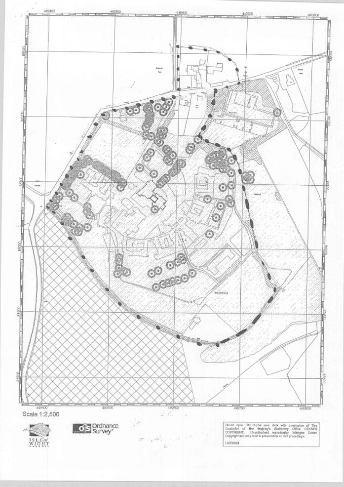
34.
Map showing
the proposed conservation area boundary.
ADDITIONAL INFORMATION
Appendix - Table of representations received
Contact point:
David Booth, Telephone No: 01983 823856
Email
address: [email protected]
|
ANDREW ASHCROFT Head of Planning Services |
TERRY BUTCHERS Portfolio Holder for Sustainable Development,
Environment and Planning Policy |
|
|
|
Proposed designation of Conservation Area for site of Whitecroft Hospital |
|
|
Officer:
David Booth |
Tel:
01983 823856 |
PROPOSED CONSERVATION AREA APPRAISAL
FOR WHITECROFT HOSPITAL SITE
The area comprises the former hospital
buildings, administrative offices and associated structures, together with the
landscaped grounds and gardens which were occupied as a psychiatric hospital
prior to its closure in 1992. The remainder is now mostly disused although the
former laundry buildings were occupied until recently and the later
administrative offices within the former nurses home located to the south east
of the main site are still in use. A number of dwellings within the site which
were formerly occupied by hospital staff are now in independent residential
use.
The site is currently available for
redevelopment/reuse and there is a development brief relating to this.
There are a number of buildings which
are considered to be of architectural and historic merit and include the main
tower and associated structures which are Listed Grade II. The original
hospital buildings which, although not on the national list are considered to
be of some architectural and historic merit in the local context, and have been
identified within the Sites and Monuments record, together with other
archaeological features.
It is therefore considered important
to identify and protect the characteristics of the site and to ensure that any
future development is given full consideration on this basis. Designation as a
Conservation Area would ensure that the Local Planning Authority considers any
future proposals in the light of the duty to preserve or enhance the character
of the area.
The former hospital is centrally situated
on the Island, approximately 3 miles south of the market town of Newport. The
site is within a rural location and forms an identifiable group of buildings in
a landscaped setting situated within a valley.
It comprises an area of
approximately 20 hectares and abuts the designated Area of Outstanding Natural
Beauty. The site is accessed via Sandy Lane which is a narrow country lane
leading from Cox’s Corner on the Newport to Chillerton road through to
Blackwater. There are currently two main access points to the site and the
former staff dwellings are also situated adjacent to the lane with separate
accesses. The former Gardeners Cottage is also in separate residential
occupation and is accessed through the hospital grounds.
The main site is contained within a
well established and fairly continuous landscaped screen comprising a mixture
of mature trees, established shrubs and hedging. Of particular note are a
number of mature pine trees which line the northern part of the site close to
the access points at Sandy Lane and these form a feature in the area and appear
in long distance views on the horizon. The relatively enclosed rural area is
typical for the siting of asylums and was chosen for its peaceful and
therapeutic qualities.
A central clock tower is a very
dominant feature which is a visible landmark both in the immediate locality and
in long distance views, particularly from the south and east. This tower
appears as a major landmark within the landscaped setting and is a significant
focal point on the Island. The remaining buildings on the site are more well
screened from outside but form a very distinctive identifiable group from
within the site.
The site is surrounded by open
fields to the south and east and the former sports ground is on rising ground
to the east and appears in distant views out from the site.
The Countryside Design Summary for
the area indicates that the area is within the East Yar Vale and is described
as a sheltered bowl characterised by intensive agricultural activity. Away form
the main road network, very narrow lanes with steep sides are most prevalent
and views down from the surrounding areas ensure that buildings are often
highly visible. Farms are generally located away from the main road frontages
and accessible down narrow hedge lined lanes.
The majority of the hospital
development was laid out and constructed over a defined period commencing in
1894 and completed 1896.
The buildings were constructed as a
County lunatic asylum and were initiated as a result of funds being made
available by the Secretary of State to the Isle of Wight County to provide its
own facilities. Isle of Wight patients were previously sent to Knowle Hospital near
Fareham and following the opening of the site at Whitecroft, a number of
patients from Knowle Hospital were transferred to the Isle of Wight.
Prior to the construction of the
hospital the site was in agricultural use and formed part of Whitecroft Farm.
There are a number of identified archaeological remains in the area and a
historic Parish Boundary from earlier land patterns.
Records indicate that the buildings were
designed by B S Jacobs of Hull and built by Garlick and Horton of London, with
the majority of bricks being made locally from clay on the site. This has
resulted in the buildings having a clearly identified character and appearance
and an overall unity of materials and design.
Some later structures have been
developed including the two storey nurses’ accommodation block situated to the
south east which was built in the 1930’s using similar red bricks and a hipped
tiled roof. This building is now used as offices from the Isle of Wight Primary
Care Trust.
Later a small single storey chapel
was built to the south east of the main hall and this has been constructed in
artificial stone with a gabled tile roof.
It appears from evidence on old maps
that the central tower and administration building were formerly linked by
other structures to the wards and the main hall. The wards themselves form a
curved complex of buildings linked by a single storey corridor. The hospital
was intended as a self sufficient community with its own workshops, laundry,
kitchen gardens and orchard, together with ancillary farming utilities.
Some of the linking buildings within
the central courtyard area have been removed so that the wards and main hall
are no longer connected to the central tower and administration building. This
area now forms a roughly crescent shaped courtyard area mostly finished in
concrete hardstanding with some small landscaped areas.
There is a substantial laundry
complex including the laundry works themselves and a major chimney together
with storage tanks situated to the south west of the main tower and
administration building. Until recently, the laundry was operational under
control of the Isle of Wight Healthcare Trust. There were a number of other
prefabricated outbuildings, situated beyond this of which only the concrete
bases now remain.
As a result of changes in government
policy to allow more emphasis on care of patients in the community, the
hospital was gradually closed down with the final patients leaving in 1992. The
majority of the buildings are now therefore disused although the former nurses’
home is still occupied as offices and the former chapel is used as a conference
room.
The disused buildings are still
generally in sound condition and have been secured although there are signs of
vandalism and removal of materials. Some basic grounds maintenance is continued
including grass cutting, although some of the woodland areas are now becoming
overgrown.
There are two main access ways to
the site, one of which was formerly served by a two storey lodge building which
is now in separate ownership. These accesses lead to the main entrance and
administration building with a car parking area adjacent. There is a level
grass area outside this building which it is understood was formerly used as a
recreation area for patients and staff.
A more modern building comprising
flat roofed structures with rendered elevation lies to the north east of the
main site and is known as Thompson House. This was constructed in the 1950’s in
connection with the hospital site but is situated away from the main buildings
at a lower level with separate access to Sandy Lane. This building, although
connected with the use of the site, is
not considered to be of any special merit in itself and does not visually
relate to the remainder of the buildings being well screened from the main site
by changes in ground level and landscape screening. It is not therefore
considered that this building should be included in the Conservation Area.
Buildings on the northern side of
Sandy Lane comprise former farm buildings, some of which appear to be similar
in date to the main hospital complex. The former farmhouse and substantial
stone built barn within the complex is probably older. The farm buildings form
a separate group outside the main hospital complex and are of some historical
interest.
Representations received as a result
of public consultation, indicate that these farm buildings are identified with
the site as a whole. Further inspection has revealed that the buildings form a
visual group in Sandy Lane along with ‘The Lodge’ and ‘Sandy Hollow’, and are
also visible as part of the group of traditional buildings from the higher
parkland in the northern part of the hospital grounds. It is therefore
considered that this group of buildings should be included within the boundary
of the proposed Conservation Area and this would enable any further proposals
to be considered in the context of the character of the area and also to
identify opportunities for future enhancement. This would have to be achieved
without prejudicing the future of the existing business use of the buildings.
A number of well known persons have been
associated with the hospital.
The main buildings were constructed
during the 1890’s as the Isle of Wight County Asylum. The Asylum was officially
opened on 3 July 1896 with the first patients transferred from Knowle on the
mainland a few days later. The buildings were designed by the architect B S Jacobs of Hull and construction was
overseen by the London firm Garlick and Horton of 43 Sloane Street, London. It
is understood that John Garlick himself supervised much of the building work
which was carried out by a workforce comprising at least 75% local men.
The surrealist poet David Gascoyne
stayed at Whitecroft as a patient in the 1960’s. it is recorded that whilst
there he met his wife to be. (See article in the Guardian, dated Tuesday 27
November 2001)
The First World War flying ace, Otto
Siefert, was a patient at Whitecroft dying there on 1 October 1915.
In addition to the above, the
hospital has many local associations and the prominence of the clock tower
brought about the Isle of Wight expression “under the clock” to describe a
person who was a patient at the hospital.
The site comprises a well defined
group of buildings within an enclosed landscape setting which, as indicated
above, were mostly constructed over a limited period and form a unified
development with a limited palette of materials and design elements.
The main features of the buildings
are characterised by the use of orange red brickwork with stone string courses,
cills and other details and hipped slate roofs. The buildings retain the
original window and door joinery which mostly comprises white painted timber
sash windows, most of which are of small pane design with typical “six over
six” sliding sashes, some of these are surmounted by three pane fanlights. The
exception being the main reception and administration block which has timber
sliding sash windows without glazing bars to the main elevation. Two of the
ward blocks contain curved bay windows also with sliding sashes, some of which
retain their original curved glass.
The main ward buildings form a
curved group linked by a single storey curved corridor. This radial layout
appears unusual (reference letter from Dr Richard Holder, Senior Architectural
Adviser for the Victorian Society). Other ancillary buildings including the
laundry are located to one side of the group and the large building known as
Rhodes – Tennyson Block is situated to the west close to the main access drive.
This building has a woodland garden area to the south west which is now
becoming overgrown, but was formerly a rose garden.
The central building in the radial
group comprises a substantial recreation building/hall. This building is
constructed of similar materials to a design which blends with the ward
buildings. However the building is emphasised by the use of architectural
detail including arched top windows and decorative terracotta plaques. Internally
the open hall appears to remain intact with large roof trusses.
The main clock tower itself,
together with the linked structures, are the only Listed buildings on the site.
As indicated previously, the tower is a substantial landmark building with a
domed cupola in Italianate style. The main tower is constructed of red
brickwork with sandstone details to match the remainder of the complex. The
building contains a water tower serving the site as a whole, together with a
clock which has white glazed illuminated dials. The whole is surmounted by a
weather vane. This building was Listed Grade II in October 1988 and
clarification from the Department for Culture, Media and Sport indicates that
the attached structure which would include the reception and administration
building are included as part of the protected building.
Whilst the remaining buildings are
of relatively plain and utilitarian design, they are of good quality and retain
most of the original detailing. The local associations and integrity of the
site as a whole, together with the use of the interesting detailing and the
overall relationship of the buildings to the central clock tower combine to add
a unity and character to the site which is considered worthy of retention and
enhancement. This combined with the somewhat unusual plan form and retention of
most of the important structures on the site together with much of the original
landscape setting means that the site is of considerable local interest and
importance.
The main setting which contained the
remainder of the original buildings is contained within a landscaped parkland
setting. The site is mostly surrounded by a substantial bank of mature planting
including mature trees and hedgerows. This is particularly noticeable along the
south western area where there is a substantial wooded boundary and along the
northern boundaries with Sandy Lane which as identified earlier, comprise a
mixture of mature tree planting with hedging which virtually screens the site from
outside. The substantial pine trees in this area are also a distinctive feature
which are seen in long distance views as a base for the views of the tower. The
eastern side is somewhat more open although still identified by banks of
planting. The are to the south west was formerly part of the kitchen
gardens and orchard and the former
gardener’s cottage still exists, although now in separate ownership. The land
falls to the south west and then rises again further to the west where the
former sports ground and pavilion can be seen in the distance.
Most of the significant trees on the site
are protected by Tree Preservation Orders, some of which are individual orders
and some group orders relating to clumps or groups of trees.
Thompson House to the north is set at a
lower level and screened from the rest of the site by changes in ground level
and tree screening.
KEY AREAS WITHIN THE SITE
Whilst the site as a whole has a strong
unity and identifiable character comprising the older buildings and the landscaped
parkland setting, there are areas within the site which have individual
characteristics. These will be shown on a map and may help to inform future
enhancement or changes to the site.
Initial inspection reveals that the site
comprises a landscaped parkland setting for the hospital buildings with a more
formal garden and grassed area situated adjacent to the entrance driveway to
the north east of the reception and administration building. The main driveway
itself is lined by mature trees. There is also an overgrown garden and woodland
setting to the western corner of the site adjacent to the Rhodes – Tennyson
building.
The crescent shaped yard area between the
administration building, clock tower and the wards consists of mainly hard
surfacing with indications of former buildings in this area. There is evidence
from the old plans that buildings formerly occupied parts of this area and the
elevations which front onto this section do not contain any features of special
merit. Part of this site would benefit from overall enhancement which may take
the form of improved landscaping and possible improvements to the buildings.
There may also be an opportunity for additional development in this area
particularly to reinstate the link between the reception building, clock tower
and the main hall linking to the curved wings to reinstate the “anchor”
footprint of the buildings which was a distinctive feature of the original
development.
The area to the south east of the wards
comprised open gardens and airing courts part of which has now been developed
with the chapel and the former nurses’ home. This area has a generally open
character although there are a number of substantial trees which are protected
by Tree Preservation Orders. There are views out from this area across the
small valley to the agricultural land opposite including parts of the sports
ground.
Trees
Residential properties fronting onto Sandy
Lane also have private gardens and the largest dwelling, known as The Pines,
also has well treed grounds.
Areas to the west of the laundry and also
to the northwest include some storage tanks and former hardstandings probably
relating to former outbuildings. These would benefit from enhancement.
The former chapel is a later building
situated to the south east of the main hall and between the original buildings
and the 1930’s former nursing home. The building itself is constructed of
artificial stone with a shallow pitched gabled roof. It is acknowledged that
the chapel is part of the historical development of the site although the
building itself is not considered to be of special architectural merit and does
not reflect characteristics of the other development on site. Further
consideration will need to be given to the future of this element of the site
as part of an overall strategy for the future proposals.
The former farm buildings are situated on
the northern side of Sandy Lane and comprise the farm house and former barns
and outbuildings. Most of these pre date the hospital development and are
attractive traditional buildings with some more recent insertions.
CONCLUSION
The site is an important element in the
social history and historic development of healthcare on the Isle of Wight. The
location, setting and design of the buildings are such that the site has a
clearly identified character and the buildings are considered to be of
significant local architectural and historic interest. In addition, the main
clock tower and associated structures are of national importance being Listed
Grade II. The combination of the physical structures, the landscape setting and
the historic development of the site make this an important area worthy of
conservation.