3.
The legislative background providing for the
designation of conservation areas is noted above. National advice is set out in
section 4 of Planning Policy Guidance 15: Planning and the Historic
Environment, and English Heritage publish criteria relating to the assessment of
subject areas.
The
Island’s UDP sets criteria for the designation of conservation areas under
policy B5 and these criteria relate to those noted nationally. The assessment
of the Whippingham area has been carried out bearing in mind both local and
national criteria.
The
Planning Services Service Plan for 2004/2005 has as one of its aims and
objectives “providing an up-to-date planning framework for the protection of
the natural, built and historic environments”, and as part of its strategic
improvements notes Task PP3 as the review of boundaries of existing
conservation areas, Task PP4 as “assess the potential for new conservation
areas” and Task PP5 as the “preparation of character statements for
conservation areas”.
4.
This recommendation is in accordance both the aims and
objectives and of the strategic improvements set out in the Service Plan, the
UDP, and is in accordance with legislative requirements and national guidance.
CONSULTATION
5.
As noted above, the proposed character statements
(Appendix 1) and draft boundary (Plan 1) have been the subject of public
consultation in accordance with the agreed procedure. The details were posted
on the Council’s website, site notices were placed within the area, and copies
of the papers were deposited at reception at the Council’s Seaclose offices and
a notice was published in the County Press. Letters were sent to the following
:- Cowes Town Council, Property Services (IoW Council), Island Watch, the Isle
of Wight Society, the Isle of Wight Industrial Archaeology Society, English
Heritage, Cowes Harbour Commission, Local Members (with the exception of the
Cowes Central which was vacant), the County Archaeologist.
6.
The consultation period lasted for approximately 5
weeks. The details of the
responses are set out in appendix 3 to this report, along with the Council’s
response to each.
7.
As a result
of the consultation, officers have revisited the parts of the proposed area and
have in some cases amended the boundary or text of the character statements
accordingly. Where this has been done the consultation analysis (Appendix 3)
has been annotated accordingly.
FINANCIAL/BUDGET IMPLICATIONS
8.
There are no direct financial implications attached to
the designation of conservation areas. The costs of consultation, advertising
and notification have been absorbed within existing budgets. The designation
may result in additional planning applications which are fee earning, but in
this case the number of properties is small and several of them are listed so
the consequent impact is considered to be minimal. There may also be additional
notifications in respect of works to trees within the area, but the Head of
Planning Services considers that this is acceptable within current budgets.
9.
Any future proposals for the enhancement of a
conservation area (under Section 71 of The Act) will be subject to the
availability of funds at the time they are proposed.
LEGAL
IMPLICATIONS
10.
The Planning (Listed Buildings and Conservation Areas)
Act 1990 at Section 69 places a duty on each local planning authority to
designate areas as conservation areas if they are considered to be of suitable
quality or interest. (The law is set out fully in section 2 of this report)
Government guidance in PPG15 confirms this duty and
indicates that an authority’s reasons for designation as reflected in its
assessment of the areas special interest, its appearance and its character are
factors which the (First) Secretary of State will take into account in
considering appeals against refusals of planning permission.
In coming to the recommendation to designate a
conservation area, consideration has been given to the rights set out in
Article 8 (Right to Privacy) and Article 1 of the First Protocol (Right to
peaceful enjoyment of possessions) of the European Convention on Human Rights.
It is recognised that the designation of a conservation area would limit
certain development rights and may be an interference with the occupier’s human
rights, but this has to be balanced against the responsibility of the Local
Planning Authority to carry out its duty to preserve and enhance the historic
environment. The action is felt to be proportionate to the legitimate aims of
the Council’s Unitary Development Plan and accords with current policies and
guidance.
If
Members are minded to designate in accordance with the recommendation in this
report, that designation takes effect immediately, though there is a
requirement to place an official notice in the London Gazette and 1 local
newspaper. In practice, and in addition to this, notifications are sent to all
of those who were notified initially, along with any further persons who made
representations, along with various official bodies and departments of the
Council.
11.
If Members are minded not to agree with a
recommendation to designate, they must ensure that their reasons are clear,
relevant, and carefully recorded.
OPTIONS
12.
There are 3 options available to Members in this
instance –
(a)
To designate the area shown on Plan 1 as a
conservation area
(b)
To choose a different boundary and provide the
necessary character assessment and reasoning to support it
(c)
To resolve not to designate and provide their reasons
in the light of Section 69
EVALUATION/RISK
MANAGEMENT
13.
The recommendation here is to designate the area shown
on Plan 1 as a conservation area (option a) as the area is considered to meet
the relevant criteria set out in both the UDP and in national guidance. It is
also in line with the aims and objectives of the relevant Service Plan.
If
Members are minded to vary the boundary (option b), or to resolve not to
designate (option c), they need to be clear as to their reasons in relation to
the relevant criteria and their duty under Section 69.
|
RECOMMENDATIONS
14
That the Executive resolves
i)
To designate the area shown on plan 1, as a
conservation area and approve the character statements, in accordance with
policy B5 of the Isle of Wight UDP in accordance with option (a) above.
|
BACKGROUND
PAPERS
15
The Planning (Listed Buildings and Conservation Areas) Act
1990
PPG15
Isle of Wight Unitary Development Plan
Planning Services Service Plan 2004/2005
Street Analysis
ADDITIONAL
INFORMATION
14.
Plan 1 – proposed boundary for conservation area
Appendix 1 – Draft character statements
Appendix
2 – Background notes re the draft CA and character area boundaries
Appendix
3 - Consultation
Contact
Point : Janet Dore, Conservation Officer (823599
email [email protected]
ANDREW ASHCROFT
Head
of Planning Services
|
TERRY
BUTCHERS
Portfolio
Holder for Sustainable Development, Environment and Planning Policy
|
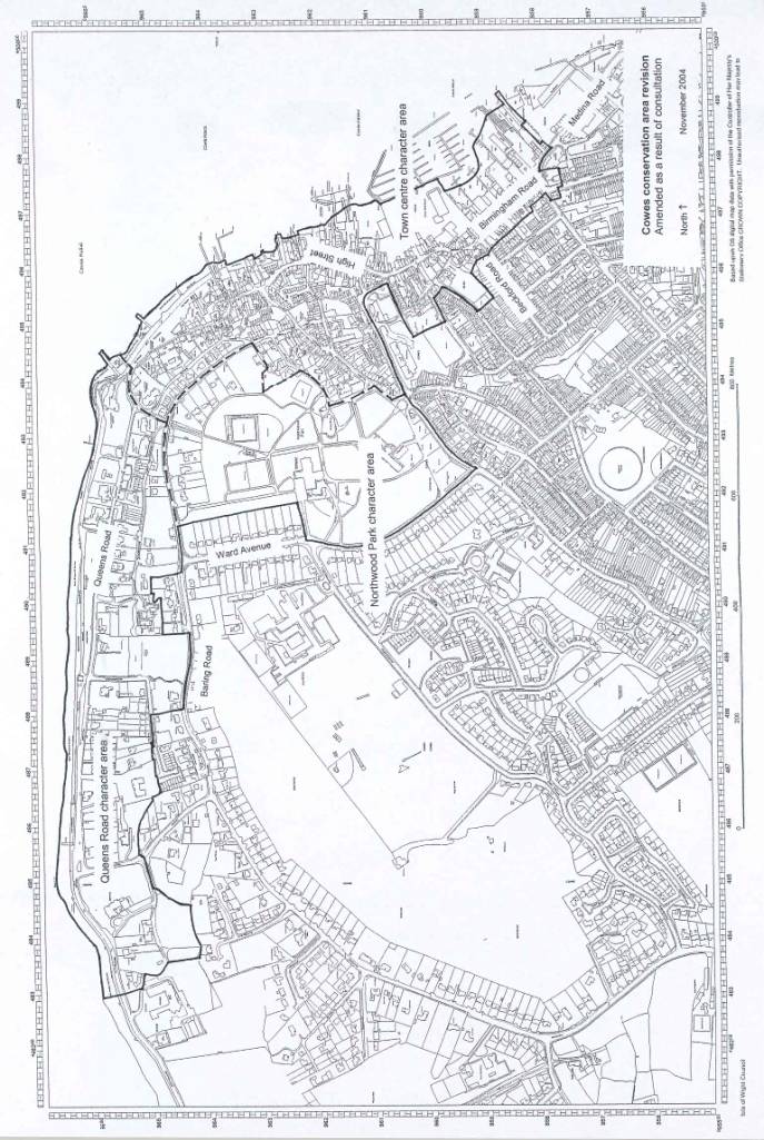
Appendix 1
cowes conservation area revision - northwood
park character area
CONSULTATION DRAFT
The legal
background
Section 69 of
the Planning (Listed Buildings and Conservation Areas) Act 1990 imposes a duty
on local planning authorities to designate as conservation areas any ‘areas of
special architectural or historic interest the character or appearance of which
it is desirable to preserve or enhance’. Section 69 also requires authorities
to review their areas from time to time to see if further designation or
alteration to existing designations is necessary.
Planning Policy
Guidance: Planning and the Historic Environment (PPG15) deals in some detail
with the assessment and designation of conservation areas in section 4, and the
adopted planning policy documents for the Island contain sections relating to
development within such areas.
Character
This park
on the hilltop is home to an elegant but now rather ‘sad’ house and its
recently restored church. The open space has a tired feel to it, though the
quality is still evident.
NB
this expression of ‘character’ is derived from the study below.
History of
development
Northwood House
was built in its current form from 1837 based on an earlier house called
Bellevue. St Marys church as it stands today dates from 1867 though in 1811
Nash enlarged an earlier building. The park was laid out to compliment the 1837
version of the house, and is included in the local register of important parks
and gardens. It has been eroded over time by the encroachment of modern
developments and the addition of leisure facilities during the period of
occupation as council offices.
Archaeology
The area
includes some of the oldest artifacts found on the Island including prehistoric
arrowheads and Roman coins. The park itself was created in 1801, before the
current Northwood House which was built in 1837.
Setting
Northwood is set
on the crest of the hill above and to the west of Cowes town. It is almost
entirely surrounded by 20th century residential developments though
these do not impose greatly on the setting due to the landform and the mature
planting within the park. Much of the old park wall remains and forms and forms
a strong edge to the character area.
Materials
The
most characteristic material is the grey render used on the house, though the
church is built of a warmer stone. Structures within the park tend to be rendered
and reflect either the age of the house or the civic era of its use.
Height, mass
& form
The house and
church are the 2 main buildings within this character area and they are both
large, imposing and isolated structures.
The scale of the
parkland provides the setting for these buildings. The modern insertions along
Castle Road do not adversely affect those settings, they are however
inconsistent in style and form and do not make a positive contribution to the
character and appearance of the area.
Typical
details
The classical
detailing of the house and its associated structures sets the style for most of
the area, with the ecclesiastical / classical form of the church making a
related but different statement. The ‘civic’ detailing of the leisure facilities
within the park is relatively low key, but reflects the period in which this
use developed.
Paving
Most of the
paving within the park is blacktop (tarmac) and relates to the areas use by the
former local council. There is little remaining visual evidence of earlier
schemes though the layout of paths is likely for the most part to follow
original routes.
Trees and
open space
This area is
typified by both trees and open space, with the 2 major buildings providing
punctuation marks within that space. The combination of planting and the
boundary wall provide a strong sense of enclosure in Church Lane.
For detailed
information on policies, legal background and national advice, please refer to
The Isle of
Wight Unitary Development Plan
The Planning
(Listed Buildings and Conservation Areas) Act 1990
Planning policy
guidance 15 – Planning and the historic environment.
CowesNorthwoodPark/consultationdraft/jd/24-Sep-04
Cowes conservation area revision – queens road
character area
consultation draft
The legal
background
Section 69 of
the Planning (Listed Buildings and Conservation Areas) Act 1990 imposes a duty
on local planning authorities to designate as conservation areas any ‘areas of
special architectural or historic interest the character or appearance of which
it is desirable to preserve or enhance’. Section 69 also requires authorities
to review their areas from time to time to see if further designation or
alteration to existing designations is necessary.
Planning Policy
Guidance: Planning and the Historic Environment (PPG15) deals in some detail
with the assessment and designation of conservation areas in section 4, and the
adopted planning policy documents for the Island contain sections relating to
development within such areas.
Character
This is an
varied but elegant residential area which has its roots in the early days of
yacht racing in the Solent. The focus of the villas is the view over the water
along with the facility to see and be seen on the promenade.
NB
this expression of ‘character’ is derived from the study below.
History of
development
This area of
substantial villas developed from the introduction of yachting as a rich man’s
sport in the 19th century. Cowes Castle predates this (1530s
origins), but its use by the RYS sits alongside the growth in popularity of the
area to the west for residences with views of the Solent where the yachts and
the racing could be viewed, and where one could promenade in fine weather.
Archaeology
This area
includes the Royal Yacht Squadron which is built upon the remains of Henry
VIII’s artillery castle. This is one of a pair of Castles built in the 16th
century to defend the Solent from attack. It was the building of these castles
which led to development of small settlements nearby which grew into Cowes.
Setting
To the north,
the Solent forms the setting to this part of the conservation area, and this
makes for a changeable backdrop dependant upon weather conditions and the state
of the tide.
To the south,
the rising ground within the area continues slightly, though the higher ground
does not impose itself on the perception of character. Thus this strip of land
does not have a strong influence from the south.
The western
boundary almost marks the extreme of development along the coast. Only a small
number of late 20th century buildings continue along the road before
development gives way to wild and overgrown hillside.
To the east the
conservation area continues, but the character of development changes, either
to the formality of Northwood Park and its environs, or the denser, smaller
scale of the old town itself.
Materials
The
eastern end of this character area makes use of smooth render for many of its
buildings, with examples of the local sand coloured brick. Roofs are mainly of
slate or red tile, and timber double hung sliding sash or casements windows
were the norm.
To the west of
Egypt Hill is a group of buildings of similar form to those further east, but
this group are of soft red brick with tiled roofs.
Height, mass
& form
Buildings are 2
or 3 stories and many are in the form of substantial villas within good-sized
plots. There are also pairs and some short terraces. The roofscape is
particularly varied and in some cases quite quirky, adding interest to the
built form.
Where modern
insertions exist they tend to be smaller single houses or larger apartment
blocks but with a less generous scale within them.
The overall
appearance is of well-proportioned buildings in generous grounds with the
elements of their design based on a generally vertical proportion, almost all
facing north addressing the promenade, which ties the area together.
Typical
details
For the most
part detailing in the area related to the period during which most of the
houses were built. In fact there is great variety in style and detailing,
though for the most part it is elegant and restrained with occasional
flourishes.
Paving
The promenade
itself is simple and of mass concrete, whilst many of the other footways have
been finished in modern slab paviours. There is some evidence of historic
survival.
Trees and open
space
The area is
typified by the generous plots and these plots accommodate a variety of mature
trees either as specimens or in groups or bands. Space is also a feature of
these generous plots and the development is at a much lower density than the adjoining
town character area. Public space in the form of tree’d slope or formal lawns,
along with the wide promenade itself, allow for gentle exercise and to see and
be seen.
Sound and
smell
The area is
generally quite quiet, with the sound of the water either lapping or crashing
depending on the weather conditions.
One significant
exception to the quiet is when racing is being run from the RYS. Visitors are
often alarmed to hear cannon fire from the start / finish line, but during the
summer this sound is an integral part of the sailing scene here.
For detailed
information on policies, legal background and national advice, please refer to
The Isle of
Wight Unitary Development Plan
The Planning
(Listed Buildings and Conservation Areas) Act 1990
Planning policy
guidance 15 – Planning and the historic environment.
CowesQueensRoad/consultationdraft/jd/
5-Nov-04
For detailed
information on policies, legal background and national advice, please refer to
The Isle of
Wight Unitary Development Plan
The Planning
(Listed Buildings and Conservation Areas) Act 1990
Planning policy
guidance 15 – Planning and the historic environment.
CowesQueensRoad/consultationdraft/jd/
24-Sep-04
cowes conservation area revision – town centre
character area
consultation draft
The legal
background
Section 69 of
the Planning (Listed Buildings and Conservation Areas) Act 1990 imposes a duty
on local planning authorities to designate as conservation areas any ‘areas of
special architectural or historic interest the character or appearance of which
it is desirable to preserve or enhance’. Section 69 also requires authorities
to review their areas from time to time to see if further designation or
alteration to existing designations is necessary.
Planning Policy
Guidance: Planning and the Historic Environment (PPG15) deals in some detail
with the assessment and designation of conservation areas in section 4, and the
adopted planning policy documents for the Island contain sections relating to
development within such areas.
Character
This is
the small scale, historic and lively centre of a town which is tied strongly to
its waterfront and to waterborne activity in many forms. Its steep streets
leading off the High Street affoed views to the Solent and mainland.
NB
this expression of ‘character’ is derived from the study below.
History of
development
Cowes has
thrived as a town, port and centre for ship and boat building since the 17th
century. This part of the conservation area relates generally to the core of
the town which developed from that time through the 18th and 19th
centuries.
Archaeology
The archaeology of the town centre is remarkable in that
the old sea wall appears to follow the line of what is now the High Street.
This would have been the focus for much of the activity in the 17th
century when trade links with the American colonies made Cowes a prosperous
centre of commerce.
Setting
The town forming
this part of the conservation area is set on a northeast facing slope at the
entrance to the river Medina. The waterfront and Cowes Roads form a vital part
of the towns’ character and thus the setting provided by the waterway is
crucial.
To the southwest
the town continues but the character here is of residential streets which
become more modern the further out one goes from the centre.
To the
southeast, along Medina Road, the historic character has been lost by clearance
for boatyard use and with the construction of modern apartment blocks. Isolated
early buildings remain leading to the floating bridge, but there is no
consistent strength of character remaining until one nears the floating bridge.
The conservation
area continues to the northwest, but the character changes and this is
recognised in the other 2 character areas forming part of the overall proposal
for this conservation area revision.
Materials
There
is a mix of materials used in this area, but the palette is one which relates
to buildings in the wider area. The local red and sand bricks are used, along
with blue/blacks, there is some use of stone and plain render, but there is
little sign of timber frames as early buildings have been refronted.
Roofs are either
slate or red plain tile, and timber windows are predominantly double hung
sliding sashes or modern replacements.
There are
exceptions to this, most notably the ‘art deco’ buildings with their
distinctive rendered finish and metal casement windows, but these are few, as
are other oddities which all add to the variety of the area.
Height, mass
& form
The key features
of this area are the small plots and narrow streets and the way buildings
address the waterfront. From this the height, mass and form are dictated and lead
to terraces of narrow buildings of 2 or 3 stories. Many have rear extensions
over part of their width and to a lesser height than the frontage block. Small
back yards, frequently without access to a road, exist but have often been
built over, especially where the buildings are in commercial use. Where
buildings back onto the water rather than a road, they often have slipways,
pontoons and davits and toward the east boatsheds and piers.
Some modern
insertions have spread over more than 1 plot and have failed to recognise the
rhythm of the streets in their design leading to over large buildings which do
not sit comfortably in the streetscape.
Typical
details
Given
the variety of ages and styles of buildings in the area, it is difficult to
identify details which are typical.
Windows to upper
levels have a mainly vertical emphasis, and were often timber double hung
sliding sashes with a painted finish. Doors of accommodation above commercial
premises were also painted and usually 4 or 6 panelled where early examples
remain.
Surviving
shopfronts have applied pilasters and some have blind boxes built in to their
fascias. Stall risers are traditionally quite deep with various finishes.
Paving
A large part of
the centre including Shooters Hill and High Street have been repaved in the
recent past. This repaving made use of red brick paviours which have little
relevance to what might have been used in the past. They are difficult to
reinstate convincingly when works are carried out and do nothing to enhance the
character of the area.
The remainder of
the area retains a traditional footway / carriageway treatment with some
natural stone kerbs and gutters and mainly blacktop surfacing with some areas
of PCC slabs on the footway. On the Parade there are areas of concrete paving.
Trees and
open space
This area is
notably dense, with its open spaces being mainly the surface car parks and
yacht haven. The Parade is an open space which is usually dominated by parked
cars, but is used for displays when events such as Cowes Week happen.
There are some
trees on the edges of the area, especially towards Northwood Park, but
generally this is a tight town centre area with little space to spare.
Day &
night / summer & winter
This area of the town does change through the day, but more
in summer than winter. In winter the area is quiet, with local people going
about their business during the day, and perhaps going to a pub or restaurant
in the evening. The town is also affected by the closure of a number of shops
completely during the winter months.
In summer the town is busier during the day with visitors,
and during the sailing season with masses of yacht crews. During the day the
visitors wander round the shops and restaurants, while the sailors buy
provisions, frequent the breakfast and sandwich bars and look for new kit in
the specialist shops before disappearing back to their boats for the day.
In the evening the town is much livelier with pubs and
restaurants bursting out onto the streets until the early hours.
For detailed
information on policies, legal background and national advice, please refer to
The Isle of
Wight Unitary Development Plan
The Planning
(Listed Buildings and Conservation Areas) Act 1990
Planning policy
guidance 15 – Planning and the historic environment.
CowesTownCentre/jd/5-Nov-04
Appendix 2
Background
note re the draft CA boundary for Cowes –
NORTHWOOD
PARK CHARACTER AREA
The controls
that come about when a conservation area is designated relate to planning
powers. They mean that express consent is required for the demolition of
buildings, and that works to trees must be notified in advance. Where new
development or change to existing buildings is proposed within or adjacent to
the area (setting), it means that care must be taken to ensure that new work
will either preserve or enhance the special character of the area. Where
proposals include the demolition of a building, then that demolition has to be
justified both in terms of why the building can’t be kept, and how good the
replacement building will be. Prior notification of works to trees allows the
Council to put a TPO in place if the tree(s) in question is of sufficient
quality and importance to the area.
Designation does
not mean that development cannot take place, either within the area or
within its setting, but that special consideration is required to ensure that
any demolition is justified, and that schemes which are acceptable on all other
planning grounds are of a suitable design and high enough standard to be
acceptable. This additional level of consideration allows Members to insist
upon the best possible standards of design for the Islands new developments, and
allows them to refuse the poor and mediocre with confidence.
The legislation
also makes provision for schemes to enhance the area, so the inclusion of areas
of potential allows for schemes to be put forward which will improve the area
in keeping with its own individual character to the same high standard.
In the case of
Cowes Northwood Park character area, the reasons for the proposed boundary
being in the location shown on the map attached to the draft character
assessment are as follows :-
·
The northern boundary separating this
area from the Queens Road character area identifies generally where the park
itself gives way to the ‘villas in large plots’ style of development.
·
The eastern boundary separates the
tight town development from what was the park itself.
·
The of the western boundary seeks to
separate the residential developments from the park
·
The southern boundary follows the
current boundary of the park excluding the apartment block and car park.
·
Minor alterations relate to the need
for the boundary to follow defined boundaries. The previous designations failed
to do this so the opportunity has been taken here to rationalise this point as
far as possible.
·
There are small areas or individual
buildings which might have been excluded from the proposed designation, but
this would leave holes in the overall coverage. In terms of management this
would be difficult, so the boundary has been drawn to cover solid areas, with
the option to note negative contributions to the overall character where possible.
Jd/Cowes town
centre/28 September 2004
Background
note re the draft CA boundary for Cowes –
QUEENS ROAD
CHARACTER AREA
The controls
that come about when a conservation area is designated relate to planning
powers. They mean that express consent is required for the demolition of
buildings, and that works to trees must be notified in advance. Where new
development or change to existing buildings is proposed within or adjacent to
the area (setting), it means that care must be taken to ensure that new work
will either preserve or enhance the special character of the area. Where
proposals include the demolition of a building, then that demolition has to be
justified both in terms of why the building can’t be kept, and how good the
replacement building will be. Prior notification of works to trees allows the
Council to put a TPO in place if the tree(s) in question is of sufficient
quality and importance to the area.
Designation does
not mean that development cannot take place, either within the area or
within its setting, but that special consideration is required to ensure that
any demolition is justified, and that schemes which are acceptable on all other
planning grounds are of a suitable design and high enough standard to be
acceptable. This additional level of consideration allows Members to insist
upon the best possible standards of design for the Islands new developments,
and allows them to refuse the poor and mediocre with confidence.
The legislation
also makes provision for schemes to enhance the area, so the inclusion of areas
of potential allows for schemes to be put forward which will improve the area
in keeping with its own individual character to the same high standard.
In the case of
Cowes Queens Road character area, the reasons for the proposed boundary being
in the location shown on the map attached to the draft character assessment are
as follows :-
·
The northern boundary follows low
water mark for continuity and as an identifiable point. Thus solid structures
are included, but pontoons and the like are excluded.
·
The eastern boundary separating this
area from the town centre character area identifies generally where the smaller
scale, tightly packed development of the town itself gives way to the ‘villas
in large plots’ style of development.
·
The short section of boundary
separating this area from the Northwood Park character area follows what would
have been the extent of the park itself.
·
The western boundary is extended to
include all of the villas along the north facing slope overlooking the Solent.
·
The southern boundary of this strip
excludes the most obvious modern developments, but marks to extent of the
villas of the Victorian and Edwardian periods which were built to take
advantage of the views. Minor alterations relate to the need for the boundary
to follow defined boundaries.
·
The previous designations failed to do
this so the opportunity has been taken here to rationalise this point as far as
possible.
·
There are small areas or individual
buildings which might have been excluded from the proposed designation, but
this would leave holes in the overall coverage. In terms of management this
would be difficult, so the boundary has been drawn to cover solid areas, with
the option to note negative contributions to the overall character where
possible.
Jd/Cowes town
centre/28 September 2004
Background
note re the draft CA boundary for Cowes –
TOWN CENTRE
CHARACTER AREA
The controls
that come about when a conservation area is designated relate to planning
powers. They mean that express consent is required for the demolition of
buildings, and that works to trees must be notified in advance. Where new
development or change to existing buildings is proposed within or adjacent to
the area (setting), it means that care must be taken to ensure that new work
will either preserve or enhance the special character of the area. Where
proposals include the demolition of a building, then that demolition has to be
justified both in terms of why the building can’t be kept, and how good the
replacement building will be. Prior notification of works to trees allows the
Council to put a TPO in place if the tree(s) in question is of sufficient
quality and importance to the area.
Designation does
not mean that development cannot take place, either within the area or
within its setting, but that special consideration is required to ensure that
any demolition is justified, and that schemes which are acceptable on all other
planning grounds are of a suitable design and high enough standard to be
acceptable. This additional level of consideration allows Members to insist
upon the best possible standards of design for the Islands new developments,
and allows them to refuse the poor and mediocre with confidence.
The legislation
also makes provision for schemes to enhance the area, so the inclusion of areas
of potential allows for schemes to be put forward which will improve the area
in keeping with its own individual character to the same high standard.
In the case of
Cowes town centre character area, the reasons for the proposed boundary being
in the location shown on the map attached to the draft character assessment are
as follows :-
·
The eastern boundary follows low water
mark for continuity and as an identifiable point. Thus solid structures are
included, but pontoons and the like are excluded.
·
The northern boundary separating this
area from the Queens Road character area identifies generally where the smaller
scale, tightly packed development of the town itself gives way to the ‘villas
in large plots’ style of development.
·
The western boundary against the
Northwood Park character area again separates the tight town development from
what was the park itself.
·
The remainder of the western boundary
seeks to separate (in general terms) the residential terraces from the
commercial centre of the town. It excludes recently developed sites such as the
Co-op and the apartment blocks close to it, but includes the car parks in the
hope that any future plans for them can enhance the conservation area and the
town centre.
·
The southeastern extremity includes
the older buildings and structures, stopping where modern developments and
extant permissions predominate.
·
Minor alterations relate to the need
for the boundary to follow defined boundaries. The previous designations failed
to do this so the opportunity has been taken here to rationalise this point as
far as possible.
·
There are small areas or individual
buildings which might have been excluded from the proposed designation, but
this would leave holes in the overall coverage. In terms of management this
would be difficult, so the boundary has been drawn to cover solid areas, with
the option to note negative contributions to the overall character where
possible.
Jd/Cowes town
centre/28 September 2004
Appendix 3
Representation
received as a result of public consultation
|
From
|
Comments
|
Response
|
|
Head of
Property Services
|
Believes that
conservation area will help improve the quality of the built environment of
the town.
|
Noted
|
|
K McNamara, 2
Westhill Road, Cowes
|
Supports the
drive to increase the level of protection; expresses concern that Cowes is
suffering a rash of ugly buildings; hopes that he CA will preserve the town.
|
Support
noted; hopefully the redesignation will raise the profile of the character of
the area and lead to buildings which respect their context.
|
|
A Turner MP
|
Supports the
proposal; asks that 2 additional areas (to the south of Egypt Hill and to the
south of Terminus Road) be considered for inclusion.
|
Support noted;
part of the area south of Egypt Hill is relatively modern suburban
development and is not considered to be of similar character or suitable for
designation; part of that area is however curtilage to properties proposed
for inclusion so the boundary has been adjusted accordingly; the area south
of Terminus Road is mixed and part of the residential area spreading south
and west from the old town and is not considered to be of similar character
or suitable for designation.
|
|
J Keenan, 29
Queens Road
|
Re Queens Road
area – fully endorses the proposal; considers it important before further
damage to this part of Cowes.
|
Support
noted; see above re respect for context.
|
|
Mrs E King,
Miramar, Baring Road, Cowes
|
Is in full
agreement with the proposal; feels that the unique waterfront area should be
protected.
|
Support
noted.
|
|
C Taylor, 12
Bridge Road, Cowes
|
Feels that the
overall scheme is a good one; makes comments re – too late to save Mornington
from demolition; suggests inclusion of green area adj. Park Court and the car
park; accepts the Medina Road boundary.
|
Support
noted; having revisited the area around Park Court, the boundary has been
adjusted accordingly.
|
|
Island Watch
|
Enthusiastically
endorse idea and offer full support; suggest other area of Cowes deserve
consideration.
|
Noted; they
will be consulted in respect of the continuing review.
|
|
L Hammond, 67
York Street, Cowes
|
Notes that
much character has been lost through new buildings being out of character;
cites various examples; welcomes proposal but seeks its recognition by
Council and officers.
|
Noted; if
accepted the enlarged conservation area will become a material consideration
in development control matters, and the character statements will assist in
understanding that character.
|
|
Cllr L
Peacey-Wilcox (Cowes Central)
|
Suggests the
inclusion of the 2 green areas and Park Court.
|
Having
revisited the area around Park Court, the boundary has been adjusted
accordingly.
|
|
Mrs I Koray,
Blue Pines, Egypt Copse, Cowes
|
Seeks the
inclusion of additional land at Dormers, Green Lane; hopes that CA will deter
highrise and out of character proposals.
|
Support
noted; having revisited the area around Dormers, the boundary has been adjusted
accordingly.
|
|
Friends of St
Marys Church, Cowes
|
Seek the
inclusion of green space adjacent to and in front of Park Court in the
Northwood character area.
|
Having
revisited the area around Park Court, the boundary has been adjusted
accordingly.
|
|
Mrs W Wardrop,
20 Granville Road, Cowes
|
Welcomes the
review; expresses concern re out of character developments and cites a number
of examples.
|
Noted.
|
|
Cowes Town
Council
|
Surprised that
St Marys road car park is included due to the development proposal; asks if
the trees in St Marys road are protected; ask that the green area beside and
in front of Park Court be included.
|
The car
park(s) are included, not to deter development, but to look towards the
enhancement and raising standards in the area; trees within conservation
areas are protected if they are of sufficient size; the Park Court boundary
has been revised.
|
|
PCC of St Mary
Church, Cowes
|
Ask that the
green area in front of and beside Park Court adjacent to the church be
included.
|
Having
revisited the area around Park Court, the boundary has been adjusted
accordingly.
|
|
English
Heritage
|
Does not
disagree with the boundary and the character areas, but queries why the area does
not extend further south than Birmingham Road; notes that the atmosphere has
been addressed, but considers the statement needs more substance in relation
to the fabric, spaces and views.
|
The Medina
Road area has not been included as the south west side has either been
redeveloped or will soon be, and building work on the north west side is
about to start; in terms of additional substance, A schedule is being prepared noting each
building, and that this schedule will be available as an addition to the overall
character statement. As that schedule will be simply observed detail it is
not considered necessary for Members to approve it. If designation is
approved, the additional work will follow shortly.
|
|
Howard Fair, 8
Egypt Copse, Cowes
|
Fully supports
proposal, especially Queens Road Area; wishes to see guidelines restricting
height of new buildings; also concern re density and road capacity.
|
Support
noted; other matters are considered on a case by case basis at present.
|
|
County
Archaeology Service
|
Make no
comment on the boundary but provide some additional information for the
character statements.
|
The
additional information has been incorporated into the statements.
|
|
Jonathan
Manser, The Manser Practice, Hammersmith Bridge, London
|
Write as
agents for owners of Mornington; concern that document should be as accurate
as possible; concern that future proposals will be assessed in light of
inaccurate criteria; provides detailed responses and illustrations relating
to various points in the draft statement for Queens Road area.
|
The
consultation document is deliberately brief, but some alterations have been
made to the text to accommodate their comments; for the most part their
comments and illustrations are mirrored in the detailed analysis of all 3
character areas being carried out to provide a second stage reference
document in addition to the brief character statements. This detailed
analysis is observed record and thus it is not considered necessary to bring
it before the Executive. This is the same process mentioned in relation to
English Heritage’s comments on the Whippingham Church report recently.
|
|
H Lowday, 1
Egypt Copse, Cowes
|
Commends
department on proposals and supports all of them; notes that future
developments should have careful planning and consultation; makes comments in
relation to the Queens Road area re the Royal influence as well as yachting;
is surprised that Egypt house is not mentioned; believes that conservation of
environment and heritage are a priority; suggests that an additional area
should be included west of Egypt Hill.
|
Support
noted; the group of properties west of Egypt Hill are mentioned; the boundary
has been amended to include the area proposed.
|
|
Northwood
House Charity
|
Complain that
they were not specifically notified of the consultation; propose the
inclusion of the land around Park Court and the car park.
|
No land
owners nor occupiers were notified individually due to the numbers involved;
consultation was advertised in the press, the Council’s web site and by site
notices; having revisited the area, officers have revised the proposed
boundary to include this land.
|