PURPOSE / REASON
1.
The report sets out evidence to determine an application under Schedule
14 of the Wildlife and Countryside Act 1981 for an order to modify the
Definitive Map and Statement by adding a footpath at Three Gates Farm
Calbourne.
DETAILS OF THE
APPLICATION / ORDER (Appendix 1)
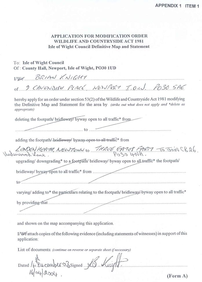
2.
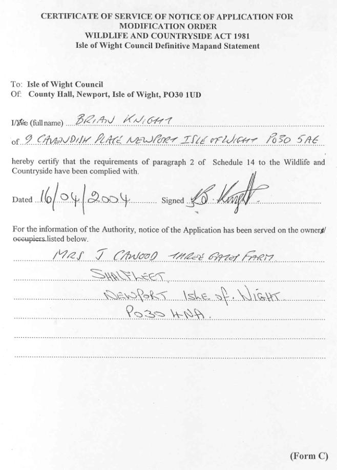
The application (Item 1) was made on 16 April 2004 by Mr B Knight
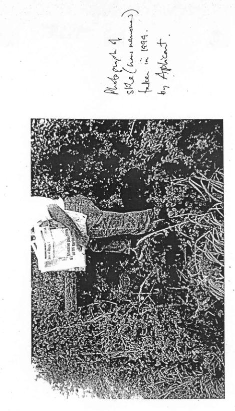
submitting 33 user witness forms and one photograph as supporting evidence.
LOCATION AND
SITE CHARACTERISTICS (Appendix 2)
3.
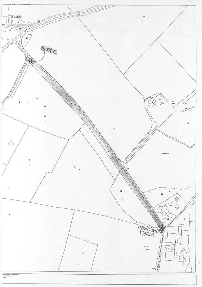
The route in question will be referred to as AB. AB is an enclosed farm
track which branches from Public Bridleway CB26 at Three Gates Farm and runs in
a north westerly direction for 550 metres to Underwood Lane near its junction
with Whiteoak Lane and Town Lane at London Heath. The owner of St Hubert’s Lodge has a private vehicular right of access over the northern half of AB
which is part of the access to the property.
4.
Maps are Items 1-7 in Appendix 2. Map 1 is an extract of the current
Definitive Map showing recorded rights of way in the area. Map 2
shows the claimed path AB. Map 3
is a plan of Three Gates Farm itself illustrating details mentioned in the
evidence. Map 4 is the Definitive Map 1952 showing the area before Three Gates
Farm was built. Map 5 is the 1973 OS Survey showing the layout after the farm
was built and essentially as it is today, in particular the farm buildings, the
enclosure of AB and the creation of the vehicular access from AB to St Hubert’s
Lodge. Maps 6 and 7 are OS Surveys 1862
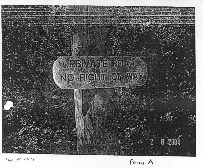
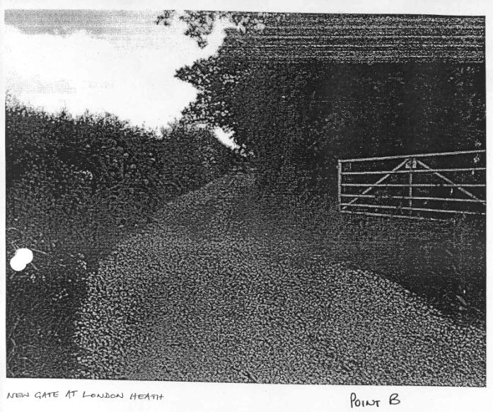
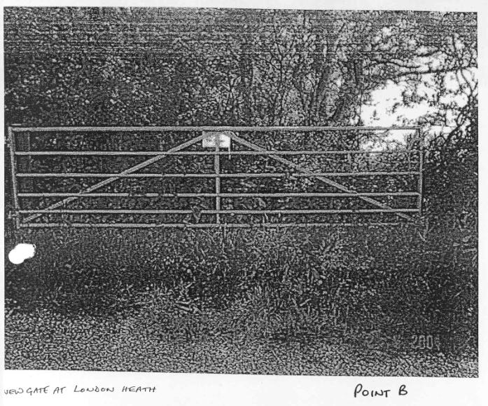
and 1908 respectively. Photographs of points A and B taken by an officer in
June 2004 are Item 8.
RELEVANT HISTORY
Factual
5.
The right of the public to use the path was
brought into question when the applicant was challenged by the owner while walking
the path in September 2003.
Committee
6.
None.
COUNCIL POLICY
7.
To comply
with the requirements of the Wildlife and Countryside Act 1981 to continuously
review the Definitive Map and Statement by making modification orders as
necessary (Rights of Way Strategy 2001-6).
FORMAL CONSULTATION (Appendix 3)
8.
Calbourne
Parish Council and the local Member for the area were consulted on the
application. An initial letter and information was sent to the landowner.
Parish and Town
Councils
9.
Calbourne Parish Council (Item 1 in Appendix 3) does not support the
application as they say they have known the way as private. It was a path to
work for workers who used Shooter’s Cottage (St Hubert’s Lodge) and a stile was
put up for this purpose. There had been
a sign for many years stating private property recently removed. During the winter a good part of the surface
is impassable. These points have been made by the landowner and are dealt with
under Landowner Evidence.
Local Member
10.
No comment.
Landowners and Occupiers
11.
There is one landowner affected by the application. The owners of St
Hubert’s Lodge have a right of way over the northern part of AB.
12.
In response to notification of the application by the applicant, the
Council received letters from the owner, Mrs Cawood, from Mr Hart, Mrs Cawood’s
son-in-law, who purchased St Hubert’s Lodge in 2004, and from Mrs Hart’s
father, Mr Frogbrook, objecting to the application on the grounds that to their
knowledge the claimed route is not a public right of way and has never been
used as such (Items 2, 3 and 4 in Appendix 3). These points are made in more
detail in the Landowner Evidence and Landowner’s Submission sections
below.
13.
Mrs Cawood, wrote a further letter to the Council on 10 August 2004
confirming points made previously (Item 5): AB has been gated and signed
‘Private Road No Right of Way’ for over 20 years. Her office is at the start of
the track and all use has been monitored, everyone using it has been challenged
or given consent. Its condition makes it impassable in winter and the
stile at point B was for private use.
The Parish Council accepts it is not a pubic right of way and does not support
the application.
THIRD PARTY REPRESENTATIONS
14.
If an order is made, there is a statutory advertisement period of six
weeks during which the public may make representations or objections.
LEGAL BACKGROUND
(Appendix 4)
15.
The Council has a duty to show all Public Footpaths, Bridleways and
Byways Open to All Traffic on the Definitive Map and Statement and to add by
modification order any such public ways not currently shown. To determine the
application, the Panel has to decide on the basis of evidence whether on
balance of probability a presumption of
dedication has been raised or a right of way exists or is reasonably alleged to
exist.
16.
The Council has a duty to make whatever order, if any, appears to them
to be required by evidence discovered, whether as submitted or as discovered
during the investigation of the matters
stated in the application.
17.
The Panel is acting in a quasi-judicial role and the decision must be
made on the basis of evidence of fact. The Panel must also apply the rules of
natural justice, in particular with respect to any landowner affected by the
decision. Guidance on the provisions of
the Wildlife and Countryside Act 1981 relating to the continuous review of the
Definitive Map and Statement and on the role of the Panel is Item 1 of Appendix
4.
18.
Guidance on the dedication of highways and evidence is given in Item 2
Planning Inspectorate Consistency Guidelines for Definitive Map Orders Section
5 (Dedication / User Evidence). A copy
of Sections 31 and 32 of the Highways Act 1980 is Item 3. Item 4, Advice Note
15 relating to interruptions in user caused by Foot and Mouth Disease, is also
relevant to this application.
GENERAL HISTORY
AND BACKGROUND OF ROUTE
19.
Three Gates Lane (Public Bridleway CB26) forms the northern part of an
old road running from the Calbourne Road through Swainston Manor across the
Yarmouth Road through Three Gates Copse to Locks Green. The section south of
the Yarmouth Road is known as Hare Lane.
First Hare Lane and then Three Gates Lane were stopped up as a bridle
road by the IW Highway Commissioners in the mid-nineteenth century although
listed in the Calbourne Tithe Map 1840 as roads. This route continues south
across Calbourne Road through Ashengrove to Newbarn Down and Brighstone Forest
where it meets the Tennyson Trail, the old road along the ridge of the downs
between Carisbrooke and Freshwater.
20.
Three Gates Lane and Hare Lane were recorded on the 1952 Definitive Map
as Bridleways CB26 and CB27 respectively, on the grounds that public bridleway
rights had been re-established by user and admitted by the owner in 1938 (see
under Documentary Evidence below).
21.
The link between Three Gates on the Yarmouth Road and London Heath
appears to date back at least to the mid-nineteenth century. A pecked line
appears in the position of AB on the Calbourne Tithe Map 1840. The OS 1862 (Map
6) does not show this path, but shows a path or track running from a bench mark
at the entrance to Three Gates Lane
directly across fields to the west of AB to the junction of Underwood
Lane at point B. On the 1908 OS Survey (Map 7) this route has disappeared and
AB is shown as an unenclosed field edge track branching off Three Gates Lane.
The track was later enclosed on the north east side as shown on the 1973 OS
Survey (Map 5).
22.
Three Gates Farm did not exist before 1964. The area consisted of copses
used for shooting. The only building was St Hubert’s Lodge, occupied for many years by the head gamekeeper of the
Swainston Estate. In 1970 the Lodge was sold off separately from the rest of
the farmland and the vehicle access developed leading at right angles from AB
which is now enclosed by a hedge and gated at the junction with AB.
23.
In 1947 the farmland was sold to Green Ltd and sold again in 1962 to
Watchingwell Farms Ltd. Both companies continued the shoot. In 1964 the land
was sold to R J Billings, a mainland farmer who built a dairy farm at the
junction of Bridleway CB26 and AB.
Three Gates Copse was cleared and the access track from the Yarmouth Road concreted.
The farmhouse was at Wheatenbread half a kilometre away, but two bungalows were
built at Three Gates for employees, a herdsman and a tractor driver. Mr
Billings also owned Great Park near Newport but did not live on either farm
himself.
USER EVIDENCE (Appendix 5)
24.
33 user witness statement forms were submitted in support of the
application. One statement represented a married couple and a further spouse
was added during interviews, making a total of 34 people claiming use as listed
in the table (Item 1 in Appendix 5).
25.
9 people who claimed to have known and used the path most frequently and
for the longest periods of time have been interviewed and also the applicant,
Mr Knight, and Mrs Knight. Notes of interviews (including any re-interviews)
are Item 3.
26.
21 further witness statements have been submitted by people who have
used the path only once or twice a year (although in some cases for a
considerable number of years) or who have used the path only recently. These
witnesses have not been interviewed. This use would be too infrequent or over
too short a period to raise a presumption of dedication in itself, but adds to
the overall total user. Many witnesses recall buying ice cream but this was
incidental to the recreational purpose of their walk.
27.
Witness evidence of any kind is counted from the time the witness
reaches 10 years of age. Claimed use begins in 1936 and continues until the
challenge in 2003 as shown in the bar chart (Item 2). The periods of most
frequent use appear to have been by older local residents and then by residents
of Old Vicarage Lane in the 1970s. Mr Anderson claims use from 1936, Mr Stone from 1953 and Mr Long
from 1959 although he also mentions using the path as a child to visit
relations (he was 10 years old in 1940). Mr Long has not used the path in the
past year. Mr Anderson’s frequent use appears to relate to his youth and 1950s
or 1960s. He did not use the bus for commuting regularly, so it is uncertain
how much he has used the track since the farm was built and has not used it
since his retirement in about 1994.
28.
Of users beginning in 1950s or later, Mrs Anderson claims use from 1956
to 1970. Mr and Mrs Smith from 1959 to 1995, Mr and Mrs Clark from 1970 to1984.
Mr and Mrs Smith also used the path with a donkey between 1974 and 1980 and Mrs
Clark also had donkeys between 1976 and 1980. Mrs Flux claims use since 1959
and Mr and Mrs Woodward since 1977, these three witnesses continuing up to the
challenge in 2003. The applicant, Mr Knight claims use since 1978 and Mrs
Knight since 1983, but both have used it only 2 or 3 times a year.
29.
Witnesses say they have never been challenged and have always regarded
the path as public. They recall no signs. Some specifically say they would not
have used the path if there was a notice saying private. Most witnesses do not
recall any gates. If there were any gates, they were always open and did not
impede their use. Two witnesses regularly used the track with donkeys between
1974 and 1980.
30.
Three older witnesses who grew up in the area say the path was used by
themselves as children with their parents and by everyone in the Newtown area
for walks and to reach the bus stop at Three Gates on the Yarmouth Road.
31.
One person with direct knowledge of the path before and after the war has
been interviewed (Item 4). Mr Fallick’s grandfather was head gamekeeper of the
Swainston Estate and occupied St Hubert’s Lodge. He moved there himself in 1936
aged 11 when his father took over as head gamekeeper and lived there until
1952.
32.
He confirms that people from the Newtown area used the track AB to reach
the bus stop. His father was the only employee in the area and would not stop
anyone. Everyone used the lane on foot, with bikes and even attempted it with
cars but the surface was badly rutted and cars would turn back. At that time
the fork to Lock’s Green was overgrown. There was no access to St Hubert’s
Lodge from AB.
33.
Mrs Anderson, Mrs Clark, Mrs and Mrs Woodward, Mr and Mrs Smith, Mr
Stone have been interviewed again
following Mrs Cawood’s main submission (see below) raising doubts concerning the claimed use.
34.
Mr Stone says he did not walk his dog right through in the 1970s and
1980s there were dogs at the farm, but went through both ways when walking for
leisure, for example up to Swainston. He is definite that his family used AB to
get the bus when on foot, ie not cycling to the stop. In the 1950s and early
60s and he often cycled down to meet his cousin at the bus stop. He says saw
the Beazley children from London Heath use it to catch the bus to Newport
Grammar School.
35.
Mr Anderson confirmed his previous evidence but declined to be
interviewed again or continue involvement in the claim. This appeared to be due
to the possibility of the applicant appealing to the Secretary of State (on
grounds the application was out of time).
Mr Long declined to be interviewed again or to be further involved in
the claim, saying that the process had taken too long.
36.
Mrs Flux’s ex-husband was interviewed (Item 5) and confirmed he was
employed between 1967 and 1974 by the
syndicate who leased the shooting rights, so Mrs Flux’s use should be
discounted as not as of right between those years.
37.
Mr Flux said he worked about three days per week at Three Gates. It was
only a wild bird shoot and no pheasants were reared. There was a gate at B in
his time and possibly one just past St Hubert’s. The condition of the track was
very bad, grown in both sides and potholed, he used it with an old van. He
thought AB was not a public right of way. A retired Swainston Estate keeper
told him they used to lock the gates once a year. He had nothing to do with the
land after 1974.
38.
Mrs Anderson Snr was a tenant of No 3 London Heath Cottages when they
were sold by the Swainston Estate in 1932 (see Landowner Submission) so use of
AB by Mr Anderson’s parents should be discounted as not as of right before this
date.
39.
Mrs Smith had a pony for her son before getting a donkey so used the
path as a bridleway from 1970 to 1980 rather than from 1974.
40.
Witnesses confirmed they did not recall any gates or signs, and did not
recall closures due to outbreaks of Foot and Mouth disease in 1981 or 2001.
41.
With reference to points in the landowner’s Submission below, electoral
registers for 1965 and 1975 show Albert and Frances Long registered in
Porchfield. It has not been confirmed whether they were Mr Long’s parents. Ian
and Joan Watson were registered at St Hubert’s in 1965 showing the property was
inhabited at that date (Item 6).
LANDOWNER
EVIDENCE – OFFICER INQUIRY (Appendix 6)
42.
Inquiries were made of members of Calbourne Parish Council in respect of
their letter. The Chairman Mr Hayward as a councilor for Thorness recommended
Calbourne area members. Mr Weeks and also Mr Barry Angell (no longer a
councillor but one for many years) were recommended as having most knowledge.
Mr Angell was included in the landowner’s submission, see Landowner Evidence
below for interview.
43.
Mr Weeks, Parish Councillor for 24 years has been interviewed (Item 1).
He lived in Newbridge then Elm Lane near Calbourne village. He is not sure
where the information in the Parish Council’s consultation letter came from,
most councilors have always lived in the area and have general knowledge, in
this case that the land was originally part of the Swainston Estate and local
men acted as beaters for the shoots .
44.
His personal recollections are that as a friend of Philip Fallick, he
visited St Hubert’s but has not been there since Mr Fallick left in
1952. AB was too muddy to cycle in
winter. He thinks there was always a gate at B, sometimes open, sometimes shut,
and originally (ie in the 1950s) a sign saying ‘Private’ which disappeared. He
recalls no sign since. He does not think AB was public. The army was in the
area in the war, and ammunition was stored in all the copses, including Lynch
Lane (south of Calbourne village), probably for some months before D-Day.
45.
Mrs Cawood, her present farm manager Mr Tosdevin and Mrs Cawood’s former
husband, Mr Frogbrook, have been interviewed (Items 2, 3 and 4). The following
points relevant to the question of dedication are summarized below.
46.
The owner states that the farm has been in the family’s ownership since
the early 1960s. She denies it is a public right of way or has ever been used
as such. She first moved to the farm in
the early 1970s as a tenant and became owner in 1982 or 1983. She lived at
Wheatenbread Farmhouse and worked the farm running a dairy herd and sheep. She
started Calbourne Classics ice cream business in 1989.
47.
Since starting this business her office has been situated adjacent to
the path with dogs tethered alongside. The farm manager has lived on site since
1994 and can see the track from his house. Her four children (the eldest born
in 1975) would often also be present. The track is therefore constantly
monitored and cannot be used by the public unnoticed. She used to ride a lot
and would be aware if any donkeys had been taken along the path but has never
seen any evidence of this.
48.
The gate at Underwood Lane was used during the Foot and Mouth outbreak
in 1981 when a closed notice was imposed on the farm. The gate at Underwood
Lane has been closed and padlocked from time to time. It was originally hinged
on the opposite side to the present one. A gate post was removed a few years
ago to allow a trailer through. For a while the gate was in the hedge.
49.
She has given some people permission to use the path, for example local
riders, but has challenged everyone else. People have only attempted to use the
path occasionally, but more in later years than when she first lived at the
farm. Everyone challenged accepted the path was private, except on an occasion
in the late summer of 2003.
50.
The present farm manager Mr
Tosdevin has worked at the farm since 1986 and lived there since 1994. He says there was a gate at the London Heath
end of the track but not at the farm end. The surface was very poor and he
improved it to get cattle and machinery along. The gate was shut when cattle
were in the nearby fields, but people left it open, probably the occupants of
St Hubert’s which was not part of the farm.
51.
About 12 or 14 years ago (ie about 1990 or 1992) he put up the notice at
the farm end of the path saying ‘Private Road No Right of Way’. There was also
a notice on the gate at London Heath. He built a stile by the old gate at
Underwood Lane for the use of children of employees living in the bungalows so
they would not have to use the gate and leave it open. The gate was shut when
cattle were in the adjacent fields, but the occupants of St Hubert’s left it
open. He replaced the gate with a wider one in 2004 and removed the stile which
was no longer needed.
52.
The farm manager says he knew the claimed path was not public although
the owner did not give any specific instruction. There was a sign for the
official bridleway CB26 at the farm.
Many people used CB26 and he would generally tell people he saw using AB
that it was private. These were usually walkers who were lost, not local people.
53.
The owner’s former husband first worked at the farm as manager from 1962
until 1967. He married Mrs Cawood in 1973 and in 1974 they became joint tenants
of the farm which was then owned by the Billings Family Trust. They moved to
the farm (Wheatenbread farmhouse) in 1975 and he lived there until 1980.
54.
In his view the claimed path has never been a public right of way. He was active with the IW Hunt (chairman 1975-80) and was clear that the
hunt had to have permission to use the path.
55.
He did not think there was a gate at London Heath and never saw one
except a temporary gate thrown across during a hunt in 1986. He recalled this
end of the track as being quite open. He drove tractors and cattle along the
track so the surface was poor. He also cleared scrub in the area between St
Hubert’s and Three Gates Farm. He used
the track regularly, sometimes daily, but he did not see people walking or on
horseback.
LANDOWNER
SUBMISSION OF EVIDENCE AND REPRESENTATIONS
(Appendix 7)
56.
Mrs Cawood has made a submission comprising statements of herself (CS
section 1), statements of her husband, her daughter and farm manager and
evidence of other witnesses in the form of statements, letters, amended officer
interview notes, emails and notes of conversations (CS section 2); documentary
evidence (CS section 3); representations and a summary of path history and
witness evidence headed Footpath Notes (CS section 4). Items submitted since
the main submission (CS section 5).
57.
A full list of submission contents is Item 1 in Appendix 7. Additional
numbering has been added for referencing purposes and the whole document is
referenced CS. Sections 1 and 4 are
included in full in the appendix (Items 2 and 3 respectively).
58.
Mrs Cawood submitted the further statements from herself [CS/1] and Mr
Tosdevin [CS/2(40)] as she considered
points had been omitted from the officer interviews or required further
clarification.
59.
The tables summarizing the witness evidence in the submission (Items 4,5
and 6 in Appendix 7) have been compiled by the case officer and a transcription
of Calbourne Parish Council minutes provided (Item 9). All other items in
Appendix 7 are as submitted by the landowner.
Mrs Cawood’s
submission: evidence of family and farm manager
60.
Evidence of Mrs Cawood, her family and farm manager is summarized in
table form in Item 4. The main points are listed below [submission reference of
supporting documentary evidence in square brackets].
1.
Family trust in existence 1966-86, one beneficiary minor until 1986, therefore
incapacity to dedicate.
2.
Path always gated at B, always signed at A and B. Same wording: Private
Road No Public Right of Way. Gate at B
and signs at A and B replaced by Mr Tosdevin soon after he was employed in
1986.
3.
Gate at B locked from time to time: some months after Foot and Mouth
restrictions ended in 1981, and following burglaries at Farm and St Hubert’s in
late 1970s/ early 1980s. Could not be always locked because of right of access
to St Hubert’s.
4.
Sign at B removed at some point by unknown person. Owner removed gate
post to widen access in 2001. Discarded post and board still attached [CS/3(7)]
(Item 7 in Appendix 7).
5.
Other gates at certain periods: one in 1954 photograph with ‘Private
Road’ notice position unknown [CS/3(10)], one near St Hubert’s, two across CB26
by farm buildings, one in hedge halfway between B and St Hubert’s track opened
across track when moving cows.
6.
Family members and employees constantly present, no one seen using path
regularly or as claimed. Mr Frogbrook, farm manager 1962-67 and joint tenant
with Mrs Cawood 1975-80, saw no public use of AB. The few people who were seen
were challenged and turned away or given permission.
7.
Users cannot have used the path as claimed: did not recall signs, gates,
interruptions (eg Foot and Mouth 1981, 2001) which are known from evidence,
users were seen using Hebberdens bus stop, not Three Gates; they never
encountered the dairy herd or farm traffic on AB or CB26.
8.
Mrs Cawood had given Mr Anderson and Mr Long permission to collect wood
on the farm in the 1970s.
9.
Aerial Surveys and OS plans show claimed route has changed over years,
users say same route.
10.
The track between St Hubert’s and point A has been waterlogged, muddy
and rutted, impassable on foot much of year.
It has only been gradually improved for farm traffic and is still poor.
Mrs Cawood’s
submission: evidence of landowner witnesses
61.
The submission includes evidence of 47 people concerning their knowledge
of the path in the form of statements, letters, emails, notes made by the
landowner and amendments to officer
interview notes. Mr Fallick and two user witnesses (Mrs Anderson and Mrs Clark)
were also contacted. In some cases
there is more than one item relating to a particular witness. This evidence is
summarized in a table (Item 6).
62.
The table Item 5 gives an indication of the overall landowner witness
evidence concerning gates and signs. This simplified summary does not take into
account the varying forms in which evidence has been submitted, how detailed or
vague the recollection, when and for how long the gates and signs were seen.
63.
Of 50 witnesses recalling the path (ie excluding the family witnesses
and those providing research material or advice), 27 mentioned signs. 18
described these as saying Private or
Private Road (most say Private). 3 mentioned the wording described by
the landowner or similar, namely wording which is inconsistent with a right of
way and 1 possibly inconsistent. 3 did not specify wording. 12 mentioned a sign
at point A and 22 mentioned a sign at point B.
64.
With respect to gates, 33 mentioned a gate at B. 2 mentioned the gate being locked at any
time (during the 1980s). 13 just say there was a gate, 11 describe it as closed
or usually closed (2 employees described the gate as shut when cattle were in
the adjacent field or when moving cattle), 5 describe it as open or usually
open or no gate visible.
65.
Other gates mentioned include: 2
witnesses mention a gate half way between B and St Huberts (ex-herdsman 1981-85 says this would be tied across
the track half way between B and St Hubert’s when moving cattle), 1 mentions
two gates across CB26 by the milking sheds in 1970s, 6 mention a gate just past
St Hubert’s. The only witness giving any detail of a gate at this last position
describes a new metal gate installed about 1980. Witnesses do not describe
these gates as locked or having signs on them.
66.
The following is a summary of evidence which gives an overview but again
does not take into account the factors mentioned above except some dates are
indicated.
67.
10 witnesses who were employed at or visited the farm at one time or
another said they saw no one using AB; 3 of these had knowledge before 1966; 2
had no knowledge before 1980 and 2 not before 1990. 4 witnesses said they never saw donkeys on AB, 2 with knowledge
in 1970s, 2 who visited or worked at the farm from 1978/9. One of these
witnesses (from 1978) said he never saw donkeys, horses or cycles.
68.
7 witnesses (5 with knowledge before 1970) said Hebberdens bus stop was
used. In 2 cases this referred to specific people, Mrs Anderson Snr and Mrs
Self. 6 witnesses said Mr Anderson
cycled to work or used Hebberdens stop and did not use Three Gates; 2 said they
never saw anyone at Three Gates bus stop; one witness said Mr Anderson might
use Three Gates stop on a Saturday evening.
Mrs Cawood’s
submission: Footpath Notes
69.
CS Section 4 Footpath Notes sets out the landowner’s summary of her
evidence, comments on user evidence and other reasons why the track is not a
public right of way. The main points are summarized below.
1.
Plans and aerial photographs show the route of the track has changed
during the user period being relied on, in particular the track once ran closer
to the ponds between point A and the turning to St Hubert’s.
2.
The condition of AB track between St Hubert’s and the farm has been so
poor that farm vehicles were damaged, demonstrating it could not have been used
much or all of the time by pedestrians as it would have been impassable.
3.
Previous Rights of Way surveys have concluded the track was not a public
footpath and there have been periods when formal objections were outstanding
demonstrating no intention to dedicate.
4.
The track has not been claimed at other likely opportunities, for
example in response to planning applications in 1966 and 2002, although one of
the users was involved in objecting to the latter.
5.
There have been several interruptions of use, namely when the land was
requisitioned during the last war, and during Foot and Mouth outbreaks in 1968,
1981, 2001.
6.
There could be no dedication between 1966 and1986 due to the existence
of the Family Trust with at least one beneficiary below the age of majority.
7.
The claimed user is insufficient to raise a presumption of dedication.
It did not take place at all, or only occasionally, or was not as of right for
the following reasons.
a)
Many landowner witnesses say people did not use Three Gates bus stop as
the track was too muddy and they could not leave their cycles. They went along
Underwood Lane to Hebberdens where the farmer allowed people to leave their
cycles and prams in a barn.
b)
Users were never seen by the owner or employees who were often present,
starting with Mr Frogbrook employed as manager 1962-1967.
c)
Users did not encounter or remember cows and farm machinery on AB
although it is busy farm and cows are milked twice a day.
d)
Users did not recall gates, signs or Foot and Mouth closures although
these are well-documented.
e)
Some use was not as of right. Mr Anderson’s parents were tenants of the
landowner Swainston Estate before 1932, Mr Anderson and Mr Long worked clearing
timber on the farm from time to time, Mr Anderson was given permission by
Mrs Cawood to collect wood in 1970s.
f)
Leisure use by people from Pickpockets Caravan Site must have been very
limited and only in summer as the site is restricted by planning regulations
and Caravanning Club certification.
g)
The users are friends and relations. Use by family and friends in a
group constitutes one act of user on each occasion only.
8.
There has always been a gate at point B, locked from time to time: two
months after 1981 Foot and Mouth official restrictions were lifted and because
of burglaries in the late 1970s and early 1980s.
9.
Extracts from the County Press show that gamekeepers were active in the
period after the war and would have stopped the public using AB.
10.
There was a gate with ‘Private Road’ sign fixed to it shown in a 1954
photograph taken by the Council at point B. There was a field gate which could
be drawn across the track half way between point B and the track to St
Hubert’s. There was a third gate shown
in Council photograph 1955 with ‘Private Road’ on it.
11.
There have always been signs at points A and B. They were replaced in
1987 and one of these signs still exists at point A. The signs have always had
the same wording as the one now at point A (Private Road No Right of Way).
12.
Personal challenges have been made since 1974 and guard dogs have
been tied up at the farm which would not
allow anyone to pass unnoticed.
13.
Landowner witnesses confirm the gates, signs, challenges, lack of use of
path by the public, and the poor state of the track as described in the points
above.
70.
Further items submitted (CS Section 5) make the following additional
points.
1.
A fax confirming date the replacement signs were made [CS/5(3)] (Item 8
in Appendix 7).
2.
Evidence from electoral registers, marriage certificate and reported
interviews with Beazleys show Mr Long did not live in Porchfield between 1968
and 1985, and the Beazley children were too young to have been seen by Mr Stone
catching the bus to Grammar School. The evidence of Mr Stone and Mr Long is
therefore unreliable and should be discounted.
3.
Extracts from Calbourne Parish Council Minutes [CS/5(22)] (transcript
Item 9) show that inquiries concerning the status of AB began when Mr Smith was
elected to the Council in 1976 and therefore were instigated by him. The
minutes show there were Private signs on AB.
4.
Aerial Survey 1969 shows a closed gate at B on both flights (28 March
and 7 April), the gate across CB26 by the milking sheds, a barrier near A as
mentioned by Mr Pye (a chain) and a slurry pile blocking AB at A as mentioned
by Mr Ryall with a path made round it by the cows going to be milked, and no
gate in the hedge between the field and AB.
5.
Aerial Survey 2000 [CS/5(30)] (Item 10) shows a closed gate at B, cows
in the field adjacent to AB, no tents (possibly one) or caravans at
Pickpockets, well-established hedge along AB, rutted surface of AB between St
Hubert’s and A.
6.
There were signs and disinfectant facilities at B relating to Foot and
Mouth from February until late summer {CS/5(27)].
LANDOWNER
WITNESS OFFICER INTERVIEWS (Appendix 6
Items 5-11)
71.
Following Mrs Cawood’s submission, 12 witnesses most likely to have
knowledge of the farm and/or the local area were interviewed. A table of
evidence and a short summary table are Items 6 and 5 in Appendix 6
respectively. Notes of interviews (one by letter), and letters from witnesses
are Items 8-10.
72.
6 witnesses recall a back and white squarish sign at B, 5 say this sign
said ‘Private’ or ‘Private Road’ and was on the gate or gate post. 1 witness
thought this went up in 1966, 1 said it had gone by late 60s, 1 recalled it
distinctly in 1970-80 but could not recall a gate, 2 saw it from 1980, 1 from 1990-2001 when there was a also sign on
the gate something like ‘No Right of Way’ 1990-2001. 2 witnesses just recalled
a sign at B ‘Private’ or ‘Private Road’. 1 said ‘Private Property’ with a
name. One recalled a sign at
A ‘Private Property No Access
1966-69. 1 recalled a sign in tree at A ‘Private Road’.
73.
Most witnesses recalled a wooden gate early on, one saying usually shut,
one usually open. One witness said it was there in 1962 but by late 60sdid not
have to open a gate. One witness described a metal gate opening inwards (from
1980). No witnesses recalled the gate or signs being changed. None recalled a
stile.
74.
3 witnesses mentioned using AB as a public path, one witness in the
1930s and 1940s, one cycling in the late 1940s and 50s, one horse riding with
her daughter during the 1970s.
75.
Item 7 is a file note of a meeting for Mr and Mrs Cawood to submit
further items to CS Section 5 and to inspect the OS aerial photograph 2000 (see
Documentary Evidence below).
Comments on
Submission Points.
76.
The following comments are made concerning points not relating to
witness evidence.
1.
Documentary evidence shows the northern half of AB has moved
approximately 10m east into the field since 1908 but before 1946. This change
is de minimus and does not affect the user evidence. There has been no change
of the southern half as claimed.
2.
A number of landowner witnesses say the section between St Hubert’s and
A has been in poor condition but the extent to which this has prevented use is
a matter of witness evidence. Many farm tracks are public rights of way, and
rights of way may be impassable at certain times. Photographs do not sustain
the view that AB has been overgrown or disappeared at any time.
3.
Previous rights of way surveys are dealt with in Documentary Evidence. A
path may not be claimed for many reasons and this is not evidence in itself of
no right of way.
4.
Land in strict settlement (trust) with minor beneficiaries would
normally prevent Common Law dedication, but would not prevent deemed dedication
under section 31 of the Highways Act 1980.
5.
Official restrictions relating to Foot and Mouth outbreaks are not
interruptions for purposes of section 31 (see Advice Note 15 in Appendix 4).
There is no clear legal advice whether wartime requisition would constitute
interruption. The likely factors are length of time and stopping of actual use.
In this case, no requisition documents have been submitted and witness evidence
is the army was present for a few
months and actual use was not stopped.
6.
The Parish Council Minutes relate to the 1976 correspondence with IWCC
see Documentary Evidence. It is not considered these minutes show that there
were private signs on AB.
DOCUMENTARY
EVIDENCE (Appendix 8)
Aerial
Photographic Surveys (Items 1-7)
77.
The following points should be borne in mind with respect to aerial
photographs. Features may be so clear as to be incontrovertible evidence, they
may be a matter of interpretation and opinion as to what they show, or they may
show nothing capable of determining the presence or absence of a physical
feature either way. Photographs cannot show the legal status of a path as this
depends on who used it and under what circumstances. Depending on factors such
as position, starting and finishing points, links to other known paths,
inferences concerning the existence of a path and its use may be drawn to
support or question other evidence. Lack of a physical trace does not prove
that a route was not being used, as the existence of such marks depends on
factors such as ground conditions, amount of use, time of year photograph was
taken.
78.
Oblique Aerial Photograph 1923 is a view from the north
showing the copses, St Hubert’s Lodge
and AB as a clear track apparently unfenced to the adjacent field. The section
approaching the fork is between trees but nevertheless apparent and therefore
probably not grown in.
79.
Aerial Survey 1946 shows AB as a clearly and uniformly marked
track from Calbourne Road to Underwood
Lane. The right fork to Lock’s Green is under tree cover but where it is
visible, it is not as clearly marked. There is a field edge track approximately
where the access to St Hubert’s Lodge now is (shown more clearly on the NMR
print than the one held by the IW Archaeological Centre).
80.
Aerial Survey 1969 shows AB
as a clear straight track. Gates are difficult to distinguish at this scale but
shows what is probably a closed gate at Underwood Lane and possibly two metal
gates across CB26 by the farm buildings. There is a boundary hedge or
vegetation between AB and the adjacent field. This field is divided
approximately in half by a track in a wider strip marked in the grass or crop.
The enlargement to approximately 1/2500 (available for the northern half of AB
only) confirms there is probably a closed gate at point B and that the access
to this track is a gap of approximately 12 metres in the boundary rather than a
gate or gates. Posts are visible at each side of the gap showing the boundary
hedge probably includes a wire fence. The access track to St Hubert’s is clear.
The land between the fork and Wheatenbread turning has also been cleared of
trees but this section of CB26 appears as a number of uneven ruts and not as a
clearly defined track.
81.
Aerial Survey 1971 shows the
Three Gates Farm buildings. The two bungalows are separated from the track AB
by an area of trees and although there appears to be an access from the
bungalows to the track and across it, the houses are screened from AB itself.
Three Gates Copse and much of the copse between the farm buildings and St
Hubert’s has been cleared. There is a worn area in the field at the same
position as the gap in the 1969 photograph showing the entrance may still be in
use although the track across the field has gone. The access track leading from
AB to St Hubert’s is clearly visible.
82.
Aerial Survey 1986 shows
trees between AB and the bungalows as in 1971.
AB itself is beneath tree cover.
83.
Aerial Survey1993 shows a
small building partially under the trees by AB at the fork. AB is clearly visible as on the 1971
photograph.
84.
Aerial Survey 2000 (submitted
by landowner) shows a closed gate at B, cows in the field adjacent to AB, one
small object, possibly a tent, on Pickpockets, a well-established hedge along
AB, lines in the surface AB which are probably ruts.
Rights of Way
Act 1932 Non-statutory Survey
85.
The Rights of Way Act 1932 provided for landowners to be able to deposit
plans of admitted highways as proof of no intention to dedicate further public
rights of way. This provision is now contained in section 31 of the Highways
Act 1980. To make comparisons with these plans, authorities were recommended to
carry out their own surveys of rights of way. Although non-statutory, these
surveys were carried out by a formal procedure afterwards developed into the
procedure adopted for the statutory surveys under the 1949 Act which produced
Definitive Maps.
86.
For the 1932 Act Survey, the surveying council were advised to send maps
out to parish councils to be marked up with rights of way in their area. These
were returned for collation by the surveying council and then a map was
published for public inspection and objections. After objections were resolved, the survey would be formally adopted by the council. The IW
Rural District Council (RDC) carried out a survey starting in 1934 when the Act
came into force and apparently concluded when the report on objection
agreements (see below) was accepted by the Council in 1938. Possibly nothing
further was done and the survey was superceded by the new Act of 1949
introducing statutory definitive maps.
87.
Calbourne Parish Council 1932 Act Survey Return 5 March 1935 (Item 8 Appendix 8)
Calbourne Parish
Council returned a map marked up with the public rights of way in their area to
the RDC in 1935. This included a route consisting of Hare Lane and Three Gates Lane taking the left-hand
fork over the claimed track AB to Underwood Lane and London Heath. The maps themselves did not distinguish
footpaths from bridleways but the papers show the survey included both. The
accompanying letter states that supposed public rights of way were marked but
should be checked with the landowners to see if they agreed as it was not known
whether they had been dedicated.
88.
Sir John Simeon’s Objection 17.2.1937 to the 1932 Act Survey and RDC
Rights of Way Sub-Committee Report 26.5.1938 (Items 9 and 10 Appendix 8)
In 1937 the
owner of the Swainston Estate submitted a formal objection to ten routes shown
on the map published by the RDC. AB is
part of route No. 8, described as a bridle road. The RDC resolved objections by
detailed consideration including
reference to the Parish Council and a meeting with the objector’s
representatives. The Sub-Committee report
lists the agreements relating to each path. No. 8 states: “It was agreed
that the claim to a right of way be withdrawn except in so far as a right of
way be included in a Bridle Road”. The
claims for Routes 3 and 4 were withdrawn without further comment, so it appears
the agreement for route 8 did not mean this.
National Parks
and Access to the Countryside Act 1949 Definitive Map Survey
89.
Calbourne Parish Council did not include Hare Lane or Three Gates Lane
to Lock’s Green or AB on their map returned for survey for the first Definitive
Map under the 1949 Act. Hare Lane and Three Gates Lane to Lock’s Green were
added to the Draft Definitive Map as
Bridleways CB26 and CB27 after an objection (not from Calbourne Parish Council)
that they had been left off.
Report of Mr R A
Macdonald under s29(2) of the National Parks and Access to the Countryside Act
1949 (Item 8 Appendix 6)
90.
The Swainston Estate Co and Messrs Green (then owners of Three Gates
Lane) objected to CB26 and CB27 being added to the Draft Map in 1954. Under the
1949 Act a barrister Mr R A Macdonald was appointed to hear objections to the
Amended Draft Definitive Map (he had also heard representations and objections
to the Draft Map).
91.
His report concluded that CB26 and CB27 should stay on the Definitive
Map and records the evidence heard. In his conclusion he refers to the
admission of a bridle road right of way by the owner in 1938. He notes that in
the 1932 Act Survey the northern part of the route takes the left-hand fork (AB
to London Heath) and whether or not there is a right of way over this route,
confirms a bridleway right over CB26 taking the right-hand fork to Lock’s Green
on the basis of the user evidence given at this inquiry. The decision to retain
CB26 and CB27 on the Amended Draft Definitive Map could be appealed to the
Minister of Housing and Local Government, but no evidence of an appeal has been
found. In any case, CB26 and CB27 were shown at the next stage on the
Provisional Definitive Map.
92.
Appeals in relation to the Provisional Definitive Map took the form of
seeking a declaration by the Quarter Sessions. The record of appeal cases in
the IW County Record Office for 1952-62 shows that Green Ltd and the Swainston
Estate did not pursue their objection to CB26 and CB27, although the Swainston
Estate did pursue objections to three other paths and its first case was heard
in 1955.
IWCC Photographs
relating to 1949 Survey
93.
Photographs were taken by IWCC in connection with the above hearings.
Photographs 1-3 in 1954, photograph 4 in 1955.
94.
Photograph 1 endorsed “St Hubert’s Lodge Entrance in Underwood Lane”
shows the track and an open wooden field gate at point B and underneath a
close-up of an illegible notice pinned to the top bar which would be facing the
hedge when the gate is open. There are possibly fence posts along the
track. Photo 2 endorsed “Entrance to Three Gates Lane north of Hare
Lane” shows a white-painted gate at Yarmouth Road. Photo 3 endorsed “Notice on
gate at Three Gates” is a close-up of this gate showing ‘Private Road’ painted
on it in black.
95.
Photograph 4 is No 1 on a key
plan of photographs of paths on the Swainston Estate taken in 1955. No 1 is the
only position north of the Yarmouth Road and is of the same gate as photographs
2 and 3.
96.
Photograph 5 and 6 (Nos 2 and 3
on the key plan) are of the gate at the north end of CB27, Hare Lane. The sign
on this gate says ‘Caution This is a Private Road J ?? Simeon 1930’.
First Review under the 1949 Act and Subsequent Reviews
97.
The First Review of the Definitive Map (Relevant Date 1968) was the only
review carried out under the 1949 Act. In 1983 the Wildlife and Countryside Act
1981 came into force, changing five-yearly review to the present continuous
review. There is no evidence that AB was put forward by Calbourne Parish
Council or by IWCC itself, or by anyone else, for inclusion in the 1968 Review,
or that it has been considered by any formal Definitive Map procedure since
that review was completed in 1980.
Correspondence
between Calbourne Parish Council and IWCC in 1976
98.
Calbourne Parish Council wrote to the County Council on 27 October 1976
saying it had been brought to their notice that private notices had been placed
at the entrance to Three Gates at Underwood Lane (point B). They were concerned
that although the lane was not a
designated footpath (ie not on the Definitive Map), it had been used by the
public for over 40 years.
99.
Extracts from Calbourne Parish Council minutes submitted by the
landowner (see below) show the issue leading to this correspondence was first
raised on 23 August under the heading Wheatenbread Lane/London Heath and the
question as to whether CB26 was a footpath or bridleway was raised at the
previous meeting 28 June (the first attended by Mr Smith, one of the present
user witnesses).
100.
The County Council’s Rights of Way officer replied on 5 November that he
assumed the track referred to is AB on his attached plan (the present AB). He
has inspected both ends of the track
and reports it has been made up, but no ‘Private’ signs are exhibited. He found
a sign on CB26 at Lock’s Green, but this was not misleading regarding bridleway
CB26. There appears to be no further correspondence concerning AB on the file which continues up to 1994.
EVALUATION AND
CONCLUSIONS
Highways Act
1980 s31
101.
Public rights over AB were first brought into question for the purposes
of s31 of the Highways Act by the landowner’s objection in 1937. The statutory
period would be 1917 to 1937. Public rights over AB were again brought into
question by implication by the objection to CB26 to Lock’s Green in 1954. There
is insufficient evidence of user available which would by itself raise a
presumption of dedication for either of these periods, although there is
documentary evidence which is discussed below in relation to a possible Common
Law dedication. The 1937 objection would in any case negate the statutory
period ending in 1954.
102.
Public rights were brought into question for a third time by personal
challenge to the present applicant in 2003, for which the statutory period
would be 1983 to 2003.
103.
Although there appears to have been public use during this period, the
owner has sited her office at A since 1989 and has been in a position to
monitor the path on a regular basis if not constantly. Although it may be
difficult to distinguish users of AB from legitimate users of CB26 and from
customers (some users were both walkers and customers), and although the stile
might reasonably be taken by users to indicate the existence of a public
footpath, several witnesses have given good evidence of challenges since 1995.
These personal challenges, see landowner witnesses Martin Steedman CS 2(41) and
Bob Shepheard CS 2(53), have been reinforced at some point by the sign currently at A, which is inconsistent with a
public right of way. This sign is fairly small and may not be noticed by users,
particularly coming from B. However it is reasonable to accept there has been
sufficient challenge to public use to demonstrate no intention to dedicate
during the statutory period of 20 years ending in 2003.
104.
The wording of the sign at A brings public rights into question, but
there is no clear evidence of the date when it was put up. The landowner has
said 1987/88 and submitted as evidence a photograph of the board and post which
was at B, to which a sign similar to the sign now at A was fixed, and also a
fax concerning supply of the signs. The photograph does not prove what the
board was used for and the fax is retrospective. Only 3 witnesses in the
owner’s submission mention such a sign at B. One said it was on the gate, while
the others recalled different wording when interviewed. Witness evidence does
not support the submission that previous signs at A and B had the same wording
as the present sign at A. There were no signs at A and B when the Council
inspected the path in 1976.
105.
If there were earlier signs, the evidence is that the wording was ‘Private’
or ‘Private Road’ which would not be capable of bringing public rights on foot
or horseback into question. Private Road is not inconsistent with a public
footpath or bridleway. ‘Private’ or ‘Private Property’ signs are not considered
to challenge use of a way, as opposed to informing that land is privately
owned, and more explicit wording is required. ‘Private’ notices attached to
trees are often intended to prevent people straying from paths into woodland
particularly where this is used for raising game birds and shooting.
106.
It has been established by photographic evidence that there were gates
at B and across CB26 in 1969, all shown closed. A closed gate does not in itself bring public rights into
question or demonstrate no intention to dedicate. The documentary evidence does
not establish the existence of other gates mentioned on AB, or that there were
any further signs expressing no intention to dedicate, or that the track did
not exist or was impassable. There is therefore insufficient evidence of
bringing into question to establish a statutory period 1967 to 1987.
107.
With respect to any other possible dates when public rights were brought
into question, Mrs Cawood has said the gate at B was locked from time to time in the 1970s and 80s and for two
months after the Foot and Mouth restrictions were lifted in 1981. None of these
periods of locking appear to have brought the rights into question. The Foot
and Mouth outbreak in 1981 is a specific date, but extending the closure for 2
months could reasonably have been interpreted by anyone using AB as part of the
official closure rather than a challenge unless they were informed
otherwise.
108.
There are therefore are no statutory periods for the purposes of section
31 of the Highways Act 1980 which can be identified other than those ending in
1937, 1954 and 2003 considered above.
Common Law
Dedication
109.
If there is insufficient evidence to satisfy deemed dedication under s31
of the Highways Act, consideration should be given to whether there is evidence
of a Common Law dedication.
110.
User in the present application is not sufficient by itself to
demonstrate an intention to dedicate on the part of the successive landowners,
but there is documentary evidence which considered in conjunction with this
user might point towards a dedication at Common Law by a previous
landowner.
111.
The documentary evidence shows the Parish Council claimed bridleway
rights in 1935. As they did not know whether there had been a dedication, the
reason for the claim is likely to have been knowledge of use. In the event,
most of this 1935 claimed route and its continuation to the downs were
confirmed as bridleway on the first Definitive Map published in 1957. Claiming
AB as the northern end of this route rather than the fork to Lock’s Green does
not seem to have been an error. Another route (route No 7) on the 1935 map was
amended at the meeting with the landowner representatives, but route No 8 was
not altered. In addition, the present witness and documentary evidence shows
that CB26 from A to the Wheatenbread turning was relatively overgrown both
before and after the war, whereas AB has always been a well-marked track,
likely to be more rather than less used than the Lock’s Green fork.
112.
No Common Law dedication could have taken place in 1937-38, or 1953-55
when there were objections or implied
objections to AB. However in 1955 the Macdonald Report concluded that bridleway
rights were established on CB26 and CB27 on the basis of 20 years user and the
report stated that ‘It appears therefore that this right of way was admitted on
behalf of Sir John Simeon as lately as 1938’.
113.
It appears that Green Ltd and the Swainston Estate accepted this
conclusion as they did not pursue objections to the next stages of the
Definitive Map procedure, although the Swainston Estate did appeal to the
Quarter Sessions for a declaration on three other paths.
114.
The IWCC photographs show there was nothing at A or B in 1954 to
indicate no intention to dedicate AB.
Mrs Cawood suggests that one of the white gates with Private Road
painted on it photographed in 1954 was at A or somewhere along AB. As stated in
Documentary Evidence, this is not believed to be a gate at A, but in any case
this gate would not be inconsistent with use as a bridleway. There is no evidence
that Green Ltd installed any gates or signs after accepting CB26 as public in
1955 to prevent use of AB to and from CB26.
115.
Witnesses for the present claim have given evidence AB was being used on
foot and cycle from 1936 through the 1940s and 1950s, and that this use was
already established by 1936. Three
landowner witnesses and Mr Fallick also confirmed this. Later use can be traced
directly back to this time in that witnesses said they were following the established
practice of family and neighbours. This continued use and reputation supports
the view that dedication had in fact occurred by 1936. There is no user
evidence with horses in the present claim until 1970.
116.
Attempted vehicle use of AB in the 1950s and 1960s has been mentioned by
present witnesses and was apparently only prevented by the poor state of the
surface. The issue of vehicle use of CB26 and the significance of the signs on
the entrance gates to CB26 and CB27 referring to Private Roads were also issues
raised at the 1955 inquiry. The sign on CB27 demonstrates a particular concern
with vehicle access to CB27 which
passes close to Swainston Manor. This may be explained by the fact that CB26
and CB27 had once been roads, closed at the request of the Simeon family.
117.
The Macdonald inquiry dealt with published amendments to the Draft
Definitive Map and as stated in the Report, came to no conclusion concerning
rights over AB, except to note that the bridleway admitted in 1938 included AB.
118.
The documentary and present witness evidence of use and reputation of
the way suggest there may have been an implied dedication prior to the Parish
Council claim in 1935 or in virtue of the owner dropping his objection to CB26
in 1955. However, the ambiguity of the final agreement on the 1937 objection to
Route No 8 and the lack of a clear statement in the Macdonald Report that the
owner’s admission in 1938 was part of the evidence on which the conclusion
regarding bridleway rights on CB26 was based, renders this evidence too
doubtful to support the conclusion of a Common Law dedication over AB.
Conclusion
119.
It is therefore concluded that there is insufficient evidence of either
deemed dedication under Section 31 of the Highways Act 1980 or of implied
dedication at Common Law to draw the conclusion that a right of way over AB
which ought to be added to the Definitive Map and Statement subsists or is
reasonably alleged to subsist.
LANDOWNER’S AND APPLICANT’S
COMMENTS ON REPORT
120.
All reports on modification order applications are submitted to
landowners for comment. If amendments to the body of the report are considered
necessary in the light of such comments, the report is again submitted to the
landowner for a brief period, otherwise comments submitted are copied at Appendix 9 together with the officer’s
response.
121.
Reports are submitted to Applicant if the recommendation is that no
order be made. Comments submitted are copied at Appendix 9 together with the
officer’s response.
122.
It has not been considered necessary to make any alterations to the
report or conclusions as a result of comments from the applicant and landowner,
other than the insertion of two references for clarity in paragraph 104 and a
correction of fact in the Landowner witness evidence table Appendix 7 Item 6
(Witness 2(51) which does not alter the witness’ evidence.
FINANCIAL
IMPLICATIONS
123.
None outside current budgets.
LEGAL
IMPLICATIONS
124.
See paragraphs 16-19 above and Appendix 4.
IMPLICATIONS
UNDER THE CRIME AND DISORDER ACT 1998
125.
The Council has a duty to make an order to modify the Definitive Map and
Statement or not according to its conclusions on the evidence. Should a right
of way be confirmed, any powers that may be available to the Council with
respect to Public Paths and Byways for the purposes of reducing Crime and
Disorder could be considered. In this case it is not considered that there are
any immediate issues as the public already has access to the area by means of
existing paths.
IMPLICATIONS
UNDER THE HUMAN RIGHTS ACT
126.
In respect of Article 6 (right to a fair trial) of the European
Convention on Human Rights, it is considered that by submission of the report
to the applicant and to landowners for comments and by advertisement of the
proposed order with the opportunity of independent determination in the event
of objection, the Council has met the requirements of this Article.
127.
In respect of Article 8 (respect for private and family life) and
Article 1 of the First Protocol (protection of property), the impacts that the
modification might have on the owners of property affected by any order which
may be made and on owners of other property in the area and users of the paths
before and after modification have been carefully considered. Whilst there may
be some interference with the rights of owners and occupiers if a modification
order is confirmed, it is considered that the recommendation is proportional to
the legitimate aim of the Council and in the public interest.
OPTIONS
128.
The Council has a duty to make an order to modify the Definitive Map and
Statement or not according to its conclusions on the evidence.
EVALUATION /
RISK MANAGEMENT
129.
In the event of an order being made and an objection being registered
during the six-week statutory advertisement period, the order must be referred
to the Secretary of State and an independent inspector will be appointed by the
Planning Inspectorate to hear the evidence and decide whether the order should
be confirmed. The Council bears the cost of arranging the inquiry and each side
bear their own costs of appearing unless there are exceptional circumstances.
130.
In the event of an order not being made, the applicant may appeal to the
Secretary of State who may direct the Council to advertise an order which then
follows the same procedure described above.
131.
After an order has been confirmed there is a 6 week period during which
any person can appeal to the High Court
on the grounds that it is not within the powers of section 53, or that
there has been a procedural failing and that the appellant’s interests have
been substantially prejudiced as a result. There is no right of appeal on
grounds of a challenge to the evidence as the objection and public inquiry
procedure provides the opportunity for this. In the High Court procedure costs
follow the event and are likely to be considerable.
132.
In making its decision the Panel is therefore recommended to carefully
follow the legal guidance set out in paragraphs 16 - 19 and in all parts of
Appendix 4. Members are reminded they should make the best decision they can on
the evidence available to them and not take into consideration whether there
will or will not be a public inquiry subsequently.
RECOMMENDATION
134.
That no order be made in response to this application and that no
other order is required as result of evidence discovered during the
investigation of matters stated in the application.
|
APPENDICES
PLEASE NOTE -
Appendices 1 and 2 are attached
to the report. Copies of Appendices 3 -
9 are available on application to Committee Services Tel 01983 823287.
Appendix 1: Application
1. Application Mr B Knight 16.4.04
Appendix 2: Route Description
1.
Map 1: Current Definitive Map: existing recorded path, scale 1/10,000
2.
Map 2: Large-scale plan of claimed route AB, scale 1/2500
3.
Map 3: Plan of Three Gates Farm scale, 1/2500
4.
Map 4: Definitive Map 1952
5.
Map 5: OS Survey 1973, scale 1/2500
6.
Map 6: OS Survey 1862
7.
Map 7: OS Survey 1908
8.
IWC Photographs of claimed route taken 2 June 2004
Appendix 3: Consultation and Landowner comments on application
1.
Letter Calbourne Parish Council to IWC 9.6.04
2.
Letter Mrs J Cawood to IWC and enclosures 19.4.04
3.
Letter Mr J Hart to IWC and enclosure 19.4.04
4.
Letter Mr K Frogbrook to IWC 7.5.04
5.
Letter Mrs J Cawood to IWC 10.8.04
Appendix 4: Legal background and guidance
1.
Provisions of the Wildlife and Countryside Act 1981 relating to the
review of the Definitive Map and Statement and Guidance on Quasi-Judicial role
of the Panel
2.
Planning Inspectorate Consistency Guidelines Forward and Section 5
(Dedication / User Evidence) (September 2005)
3.
Sections 31 and 32 of the Highways Act 1980
4.
Planning Inspectorate Advice Note 15: Breaks in User Caused by Foot and
Mouth Disease (December 2002)
Appendix 5: User evidence
1.
User evidence table: Witness Statements
2.
Bar chart of user evidence
3.
File notes of User witness interviews
4.
File note interview Mr P Fallick 29.10.04
5.
File note interview Mr K Weeks 1.11.05
6.
File note interview Mr P Flux 1.12.05
7.
File note: electoral registers
Appendix 6: Landowner evidence
1.
File note interview Mrs J Cawood and additional note
2.
File note Mr P Tosdevin 12.11.04
3.
File note interview Mr K Frogbrook
4.11.04
4.
Summary table of Landowner Witness Evidence: Officer Interviews
5.
File note Meeting IWC with Mr and Mrs G Cawood 27.1.06
6.
Letter Mrs M Coghlan to IWC 14.7.05
7.
Letter and statement Mr and Mrs R Ryall to IWC
8.
File notes of Landowner witness interviews
9.
Correspondence Mr J Pye and IWC
Appendix 7: Landowner’s Submission (Mrs Cawood) 3.7.05
1.
List of submission contents
2.
Section 1: Mrs Cawood statement
3.
Section 4: Footpath Notes
4.
Summary table and Summary of Evidence of Landowner, family and farm
manager
5.
Short summary of Witness Evidence: signs and gates
6.
Summary table of Evidence of Landowner witness evidence
7.
CS/3(7) Photograph of gate post and board
8.
CS/5(3) Fax Corinthian Sports Club (R J Billings) to Mrs Cawood
9.
CS/5(22) Extracts Calbourne Parish Council Minutes from 1976, 1977,
1979, 1980, 1983
10.
OS Aerial Survey 2000 extracts
Appendix 8: Documentary evidence
1.
Oblique Aerial Photograph 1923
2.
Aerial Survey 1946
3.
Aerial Survey 1969
4.
Aerial Survey 1971
5.
Aerial Survey 1986
6.
Aerial Survey 1993
7.
Aerial Survey 2000
8.
Calbourne Parish Return 5.3.1935 Rights of Way Act 1932 Survey (Map and Letter)
9.
Sir John Simeon Objection 17.2.1937 Rights of Way Act 1932 Survey
10.
RDC Rights of Way Sub-Committee Report 26.5.1938
11.
Report of R A MacDonald NPACA 1949 pages 13-16 (Calbourne)
12.
IWCC Photographs Swainston Estate 1954
13.
IWCC Photographs Swainston Estate 1955 and Key plan
14.
Calbourne PC / IWCC correspondence 1976
Appendix 9: Applicant and Landowner comments on report and officer’s response
1.
Applicant comments and officer’s response.
2.
Landowner comments and officer’s response.
BACKGROUND
PAPERS
NB: Items with
asterisk appear in Appendices.
Aerial
photographs are copied for identification only and original prints may need to
be inspected to see the features
referred to in the evidence.
1.
*Application for Modification
Order Mr B Knight 16.4.04
2.
33 Witness Statements (separate file)
3.
*Letter Calbourne PC to IWC 9.6.04
4.
*Letters Mrs J Cawood to IWC 19.4.04 and 10.8.04
5.
*Letter Mr J Hart to IWC 19.4.04
6.
*Letter Mr K Frogbrook to IWC 7.5.04
7.
Letter IWC to Mrs J Cawood 12.5.06
8.
Letters IWC to Mrs L Kerley, Calcourne Parish Council 1.6.04
9.
Letters IWC to Cllr Mrs Wareham, Cllr Mrs Butchers 1.6.04
10.
RFI on ownership return Mrs J Cawood
9.8.04
11.
File note 9.11.04 telephone call to Mrs A Chambers (Calbourne Parish
Councillor)
12.
Letter IWC to Mrs L Kerley, Calbourne PC 1.11.04
13.
Calbourne PC minutes of meeting 7 June 2004
14.
*File Notes of 13 User, 10 Landowner and 3 Other Witness Interviews
15.
Mrs J Cawood to IWC Submission of Evidence 1.7.05 and subsequent
additions
16.
*Letter Mrs M Coghlan to IWC 12.10.05
17.
*OS Surveys 1862, 1908, 1973, current OS Landline
18.
*Extract of Definitive Map 1952
19.
*Oblique Aerial Photograph 1923 NGR Index No SZ4490/4 Accession No
CCC11753, National Monuments Record (NMR), English Heritage, Swindon
20.
*Aerial Surveys 1946, 1971, 1986, 1993 IWC Archaeological Centre,
Clatterford Road, Carisbrook (tel
01983 823810)
21.
*OS Aerial Survey 1969 National Monuments Record, English Heritage,
Swindon
22.
*Enlarged OS Aerial Survey 1969 IWC Planning Services, Seaclose Offices
23.
Calbourne Tithe Map and Reference Book 1840 JER/ T/62 IWC Record Office
24.
IW Highway Commissioners Minutes 1813-1895 Vols 5,6,7 IWC Record Office
25.
Commons, Open Spaces and Footpaths Preservation Society booklet ‘The
Rights of Way Act 1932’
26.
National Parks and Access to the Countryside Act 1949 part IV s27-38
27.
*Calbourne Parish Return 2.3.1935 Rights of Way Act 1932 Survey
IWCC/S/FP/Box 5 IWC Record Office
28.
*Sir John Simeon Objection 17.3.1937 Rights of Way Act 1932
IWCC/S/FP/Box 5 IWC Record Office
29.
*Rights of Way Sub-Committee Report 26.5.1938 Index and pp13-16
(Calbourne) IWCC/S/FP/Box 5 IWC Record
Office
30.
*Mr R A Macdonald Report NPACA 1949 Report IWCC/S/FP/Box 5 IWC
Record Office
31.
*IWCC Photographs 1954 IWCC/S/FP/Box 9
IWC Record Office
32.
*IWCC Photographs CB8 and CB25 1955 and Key Plan IWCC/S/FP/Box 5 IWC Record Office (Key plan not
reproducible)
33.
IW Quarter Sessions and Appeal Committee Record of Cases 1952-1962 IWC
Record Office
34.
*RWA/CB900 File note Record Office (electoral registers) 6.2.06
35.
*Planning Inspectorate Advice Notes No 15
36.
*Planning Inspectorate Consistency Guidelines Section 5 (Sept 2005),
Section 2 para 20 and Section 7 para 25.
37.
Rights of Way Law Review (RWLR) Trusts of Land and Dedication of
Highways
6.3 pp37-39
Contact Point:
Alexandra Russell, Definitive Map Officer, Rights of Way, Engineering
Services, Tel :
857230 email :
[email protected]
DEREK ROWELL,
Strategic
Director of Economic Development and Regeneration